
| Birth | : | 18 May 1872 Ohio, USA |
| Death | : | 26 Jul 1953 Clatonia, Gage County, Nebraska, USA |
| Burial | : | Saint John Cemetery, Saint Bernard, Hamilton County, USA |
| Coordinate | : | 39.1643982, -84.5053024 |
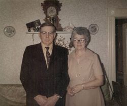
| Description | : | "JOHN H. WAYMAN - In Clatonia township John Henry Wayman resides upon and gives his able supervision to a farm of one hundred and twenty-five acres which he rents from the Steinmeyer estate, and he is the owner of a farm of one hundred and sixty acres in Lincoln county, Nebraska, as well as of property in the village of Clatonia. Mr. Wayman was born at Longrun, Licking county, Ohio, on the 9th of May, 1872, a son of Henry and Sophia (Heisner) Wayman, the former of whom died in Holt county, Nebraska in 1907, at the age of eighty-two years... Read More |
frequently asked questions (FAQ):
-
Where is John Henry Wayman's memorial?
John Henry Wayman's memorial is located at: Saint John Cemetery, Saint Bernard, Hamilton County, USA.
-
When did John Henry Wayman death?
John Henry Wayman death on 26 Jul 1953 in Clatonia, Gage County, Nebraska, USA
-
Where are the coordinates of the John Henry Wayman's memorial?
Latitude: 39.1643982
Longitude: -84.5053024
Family Members:
Spouse

Children
Flowers:


Nearby Cemetories:
1. Saint John Cemetery
Saint Bernard, Hamilton County, USA
Coordinate: 39.1643982, -84.5053024
2. Vine Street Hill Cemetery
Cincinnati, Hamilton County, USA
Coordinate: 39.1516991, -84.5091019
3. Saint Mary Cemetery
Saint Bernard, Hamilton County, USA
Coordinate: 39.1664009, -84.4880981
4. Spring Grove Cemetery
Cincinnati, Hamilton County, USA
Coordinate: 39.1647900, -84.5231500
5. First German Protestant Cemetery
Avondale, Hamilton County, USA
Coordinate: 39.1492004, -84.4863968
6. Clifton United Jewish Cemetery
Cincinnati, Hamilton County, USA
Coordinate: 39.1470871, -84.5292816
7. Hillside Chapel Crematory and Columbarium
Cincinnati, Hamilton County, USA
Coordinate: 39.1393509, -84.5247192
8. Methodist Protestant Cemetery (Defunct)
Cincinnati, Hamilton County, USA
Coordinate: 39.1324770, -84.4983160
9. Wesleyan Cemetery
Cincinnati, Hamilton County, USA
Coordinate: 39.1599998, -84.5468979
10. Old Finneytown Cemetery
Finneytown, Hamilton County, USA
Coordinate: 39.1962220, -84.5206120
11. Walnut Hills Cemetery
Cincinnati, Hamilton County, USA
Coordinate: 39.1355950, -84.4809040
12. Walnut Hills Jewish Cemetery
Evanston, Hamilton County, USA
Coordinate: 39.1403700, -84.4731300
13. Calvary Cemetery
Cincinnati, Hamilton County, USA
Coordinate: 39.1403008, -84.4697037
14. Longview Hospital Cemetery
Roselawn, Hamilton County, USA
Coordinate: 39.1887730, -84.4691660
15. Third Quaker Cemetery (Defunct)
Cincinnati, Hamilton County, USA
Coordinate: 39.1542400, -84.5523720
16. Convent of the Good Shepherd Cemetery (Defunct)
Carthage, Hamilton County, USA
Coordinate: 39.2055250, -84.5042780
17. Bishop Cemetery (Defunct)
College Hill, Hamilton County, USA
Coordinate: 39.1910210, -84.5489570
18. Griffins Station Cemetery
Carthage, Hamilton County, USA
Coordinate: 39.2047000, -84.4770730
19. Fulton Cemetery
Hyde Park, Hamilton County, USA
Coordinate: 39.1406364, -84.4506302
20. City Infirmary Cemetery
Hartwell, Hamilton County, USA
Coordinate: 39.2123500, -84.4806700
21. Christ Church Cemetery
Over-The-Rhine, Hamilton County, USA
Coordinate: 39.1126480, -84.5157623
22. Second Quaker Cemetery (Defunct)
Cincinnati, Hamilton County, USA
Coordinate: 39.1153090, -84.5305240
23. Baltimore Pike Cemetery
Cincinnati, Hamilton County, USA
Coordinate: 39.1397018, -84.5681000
24. Gard-Brown Cemetery
North Bend, Hamilton County, USA
Coordinate: 39.2035200, -84.5553300