
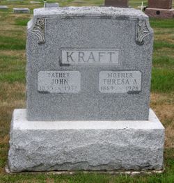
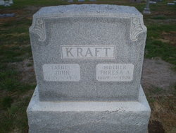
John Kraft
| Birth | : | 19 Nov 1853 Hessen, Germany |
| Death | : | 17 Nov 1932 Mapleton, Monona County, Iowa, USA |
| Burial | : | Bollinger County Memorial Park Cemetery, Marble Hill, Bollinger County, USA |
| Coordinate | : | 37.2689018, -89.9871979 |
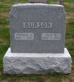
| Description | : | Another Pioneer Called by Death Resident in this community many years passes away at home of daughter Funeral services for John Kraft, pioneer Mapleton citizen and retired farmer who passed away Thursday of last week [17 Nov 1932] in the home of his daughter, Mrs. T.O. Burson, from the infirmities of old age were held at 10 o'clock Saturday morning in the Methodist church with Rev C.H. Van Meter, pastor of the church officiating. Interment was in Mount Hope cemetery under the direction of the Byers Funeral Home. Mr. Kraft was born in Altenhain Hessen Germany November 19, 1853, and had he lived... Read More |
frequently asked questions (FAQ):
-
Where is John Kraft's memorial?
John Kraft's memorial is located at: Bollinger County Memorial Park Cemetery, Marble Hill, Bollinger County, USA.
-
When did John Kraft death?
John Kraft death on 17 Nov 1932 in Mapleton, Monona County, Iowa, USA
-
Where are the coordinates of the John Kraft's memorial?
Latitude: 37.2689018
Longitude: -89.9871979
Family Members:
Parent
Spouse

Siblings
Children
Flowers:


Nearby Cemetories:
1. Bollinger County Memorial Park Cemetery
Marble Hill, Bollinger County, USA
Coordinate: 37.2689018, -89.9871979
2. Baker Cemetery
Marble Hill, Bollinger County, USA
Coordinate: 37.2722015, -89.9869003
3. Shell Cemetery
Lutesville, Bollinger County, USA
Coordinate: 37.2839012, -89.9693985
4. Hahn Cemetery
Lutesville, Bollinger County, USA
Coordinate: 37.2886009, -89.9772034
5. Patterson Family Cemetery
Bollinger County, USA
Coordinate: 37.2511100, -90.0107100
6. Slaybaugh Cemetery
Lutesville, Bollinger County, USA
Coordinate: 37.2982150, -89.9851870
7. Eaker Cemetery
Lutesville, Bollinger County, USA
Coordinate: 37.2778015, -89.9516983
8. Dry Creek Cemetery
Lutesville, Bollinger County, USA
Coordinate: 37.2675018, -90.0291977
9. Marble Hill Cemetery
Marble Hill, Bollinger County, USA
Coordinate: 37.3032799, -89.9701309
10. El Nathan Cemetery
Marble Hill, Bollinger County, USA
Coordinate: 37.3086710, -89.9757960
11. Clubb Creek Church Cemetery
Trowel, Bollinger County, USA
Coordinate: 37.2318306, -90.0125275
12. Lower Deck Cemetery
Lutesville, Bollinger County, USA
Coordinate: 37.3078003, -90.0119019
13. Crites Cemetery
Trowel, Bollinger County, USA
Coordinate: 37.2318993, -90.0164032
14. Perkins Cemetery
Bollinger County, USA
Coordinate: 37.2738991, -89.9313965
15. Hahn Chapel Cemetery
Marble Hill, Bollinger County, USA
Coordinate: 37.3061638, -89.9492645
16. Saint Johns Cemetery
Leopold, Bollinger County, USA
Coordinate: 37.2585983, -89.9282990
17. Shelton Cemetery
Huxie, Bollinger County, USA
Coordinate: 37.2556000, -90.0481033
18. Myers Cemetery
Glenallen, Bollinger County, USA
Coordinate: 37.3171997, -90.0096970
19. Cane Creek Cemetery
Huxie, Bollinger County, USA
Coordinate: 37.2468987, -90.0485992
20. James Cemetery
Bollinger County, USA
Coordinate: 37.2346600, -90.0478900
21. Glen Allen Cemetery
Glenallen, Bollinger County, USA
Coordinate: 37.3201100, -90.0320100
22. Upper Deck Cemetery
Glenallen, Bollinger County, USA
Coordinate: 37.3236008, -90.0444031
23. Formway Cemetery
Bollinger County, USA
Coordinate: 37.3166900, -89.9165400
24. Myers Cemetery
Huxie, Bollinger County, USA
Coordinate: 37.2677994, -90.0839005