
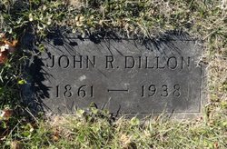
John Randolph Dillon
| Birth | : | 3 Nov 1861 Franklin County, Virginia, USA |
| Death | : | 17 Feb 1938 Cabell County, West Virginia, USA |
| Burial | : | Milford Union Cemetery, Milford, Hunterdon County, USA |
| Coordinate | : | 40.5667000, -75.0922012 |
| Plot | : | 33-101-3 |
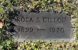
| Description | : | The Herald Dispatch (Huntington, WV) - Friday - 2/18/1938 Dillon, John R. - Date of Death: Thursday, 2/17/1938 Obituary John R. Dillon - Seventy-six years old, of 1036 Twenty-second Street, who died yesterday morning in a Huntington hospital, will be buried tomorrow morning in Spring Hill Cemetery following funeral services at 10:30 o'clock at the residence with Rev. C. H. Kelley, pastor of Emmanuel Methodist Episcopal Church, South, officiating. Surviving are four daughters, Mrs. L. J. Truchoveski, with whom he made his home, Miss Rosa Dillon, at home, Mrs. Ralph Elliott, of Hopewell, Va., and Mrs. M. P. Wright, of Lyburn, W. Va.;... Read More |
frequently asked questions (FAQ):
-
Where is John Randolph Dillon's memorial?
John Randolph Dillon's memorial is located at: Milford Union Cemetery, Milford, Hunterdon County, USA.
-
When did John Randolph Dillon death?
John Randolph Dillon death on 17 Feb 1938 in Cabell County, West Virginia, USA
-
Where are the coordinates of the John Randolph Dillon's memorial?
Latitude: 40.5667000
Longitude: -75.0922012
Family Members:
Parent
Spouse
Siblings
Children
Flowers:


Nearby Cemetories:
1. Milford Union Cemetery
Milford, Hunterdon County, USA
Coordinate: 40.5667000, -75.0922012
2. Milford Christian Churchyard
Milford, Hunterdon County, USA
Coordinate: 40.5685425, -75.0972214
3. Pursell Burying Ground
Upper Black Eddy, Bucks County, USA
Coordinate: 40.5584410, -75.0933950
4. Mount Pleasant Cemetery
Mount Pleasant, Hunterdon County, USA
Coordinate: 40.5835267, -75.0536867
5. Upper Tinicum Cemetery
Upper Black Eddy, Bucks County, USA
Coordinate: 40.5292650, -75.0822933
6. Oak Hill Golf Course Burial Ground
Holland, Hunterdon County, USA
Coordinate: 40.6061170, -75.1085940
7. Erwin Family Cemetery
Erwinna, Bucks County, USA
Coordinate: 40.5279105, -75.0674030
8. Everittstown Methodist Cemetery
Everittstown, Hunterdon County, USA
Coordinate: 40.5655823, -75.0279922
9. Frenchtown Cemetery
Frenchtown, Hunterdon County, USA
Coordinate: 40.5237503, -75.0605545
10. Stewart Cemetery
Tinicum, Bucks County, USA
Coordinate: 40.5148430, -75.1368700
11. Rock Ridge Chapel Cemetery
Upper Black Eddy, Bucks County, USA
Coordinate: 40.5010986, -75.1181030
12. Oak Summit Cemetery
Kingwood, Hunterdon County, USA
Coordinate: 40.5419000, -75.0051000
13. Holland Presbyterian Church Cemetery
Holland, Hunterdon County, USA
Coordinate: 40.5748700, -75.1861600
14. Robins Family Burying Ground
Pattenburg, Hunterdon County, USA
Coordinate: 40.6284027, -75.0432663
15. Finesville Union Cemetery
Finesville, Warren County, USA
Coordinate: 40.6010300, -75.1773900
16. Garrison-Tharp Cemetery
Pattenburg, Hunterdon County, USA
Coordinate: 40.6340294, -75.0494461
17. Nockamixon Union Cemetery
Ferndale, Bucks County, USA
Coordinate: 40.5314903, -75.1812820
18. Hughesville Cemetery
Warren Glen, Warren County, USA
Coordinate: 40.6269455, -75.1559296
19. Marshall-Cooper-Ridge Cemetery
Tinicum, Bucks County, USA
Coordinate: 40.4890160, -75.0906330
20. Baptistown Cemetery
Baptistown, Hunterdon County, USA
Coordinate: 40.5240100, -75.0061190
21. Saint Thomas Episcopal Church Cemetery
Pittstown, Hunterdon County, USA
Coordinate: 40.5606900, -74.9890000
22. Saint Luke's Evangelical Lutheran Church Cemetery
Ferndale, Bucks County, USA
Coordinate: 40.5290000, -75.1835000
23. Riegelsville Union Cemetery
Riegelsville, Bucks County, USA
Coordinate: 40.5957920, -75.1965020
24. Bloomsbury Methodist Churchyard
Bloomsbury, Hunterdon County, USA
Coordinate: 40.6536522, -75.0852127