

John Robbins
| Birth | : | 12 Apr 1749 Ashford, Windham County, Connecticut, USA |
| Death | : | 16 Nov 1828 Deerfield, Franklin County, Massachusetts, USA |
| Burial | : | North Cemetery, Deerfield, Franklin County, USA |
| Coordinate | : | 42.5635100, -72.6249200 |
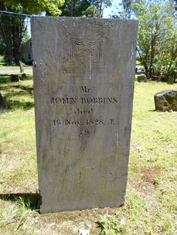
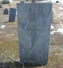
| Inscription | : | Mr John Robbins died 16 Nov 1828 AE 79 |
| Description | : | son of Joseph Robbins and Lucy (___) Robbins m. Hannah Wise children (at least): Lydia b. 7 Sept 1770 Ashford, Connecticut John b. 1 Feb 1771 Esther b. 18 Sept 1773 in Ashford, Connecticut Joseph b. 4 July 1776 in Ashford, Connecticut [thanks for assist from FAG contributor 49583920] |
frequently asked questions (FAQ):
-
Where is John Robbins's memorial?
John Robbins's memorial is located at: North Cemetery, Deerfield, Franklin County, USA.
-
When did John Robbins death?
John Robbins death on 16 Nov 1828 in Deerfield, Franklin County, Massachusetts, USA
-
Where are the coordinates of the John Robbins's memorial?
Latitude: 42.5635100
Longitude: -72.6249200
Family Members:
Spouse
Children
Flowers:


Nearby Cemetories:
1. Baptist Cemetery
Deerfield, Franklin County, USA
Coordinate: 42.5555992, -72.6258011
2. Mater Dolorosa Cemetery
Greenfield, Franklin County, USA
Coordinate: 42.5758000, -72.6165000
3. Calvary Cemetery
Greenfield, Franklin County, USA
Coordinate: 42.5764008, -72.6138992
4. Old Catholic Cemetery
Greenfield, Franklin County, USA
Coordinate: 42.5795753, -72.6064215
5. Old Deerfield Burying Ground
Deerfield, Franklin County, USA
Coordinate: 42.5449982, -72.6097031
6. Green River Cemetery
Greenfield, Franklin County, USA
Coordinate: 42.5804400, -72.6052500
7. Hawks Cemetery
Deerfield, Franklin County, USA
Coordinate: 42.5555992, -72.6583023
8. Savage Farm Cemetery
Deerfield, Franklin County, USA
Coordinate: 42.5336700, -72.6245300
9. Laurel Hill Cemetery
Deerfield, Franklin County, USA
Coordinate: 42.5416670, -72.5973020
10. Lower Meadow Cemetery
Greenfield, Franklin County, USA
Coordinate: 42.5945600, -72.6200300
11. Cosby Family Cemetery
Shelburne, Franklin County, USA
Coordinate: 42.5566400, -72.6702100
12. Federal Street Cemetery
Greenfield, Franklin County, USA
Coordinate: 42.5941400, -72.5977300
13. South Cemetery
Shelburne, Franklin County, USA
Coordinate: 42.5819016, -72.6699982
14. East Deerfield Cemetery
Deerfield, Franklin County, USA
Coordinate: 42.5555992, -72.5642014
15. Burnham Cemetery
Montague, Franklin County, USA
Coordinate: 42.5875300, -72.5720140
16. High Street Cemetery
Greenfield, Franklin County, USA
Coordinate: 42.6044840, -72.5806660
17. Fairway Avenue Cemetery
Montague, Franklin County, USA
Coordinate: 42.5924270, -72.5646970
18. North Meadows Cemetery
Greenfield, Franklin County, USA
Coordinate: 42.6171989, -72.6333008
19. Shelburne Center Cemetery
Shelburne, Franklin County, USA
Coordinate: 42.5830000, -72.6969600
20. East Shelburne Cemetery
Shelburne, Franklin County, USA
Coordinate: 42.6105995, -72.6694031
21. Hill Cemetery
Shelburne, Franklin County, USA
Coordinate: 42.5984344, -72.6878815
22. Springdale Cemetery
Montague, Franklin County, USA
Coordinate: 42.5884700, -72.5530900
23. Aaron Clark Memorial Cemetery
Montague, Franklin County, USA
Coordinate: 42.5836200, -72.5471600
24. Saint Annes Cemetery
Montague, Franklin County, USA
Coordinate: 42.5861300, -72.5480600