
| Birth | : | 1802 Orangeburg County, South Carolina, USA |
| Death | : | 15 Aug 1890 Cades Cove, Blount County, Tennessee, USA |
| Burial | : | Harrell Cemetery, Bean Station, Grainger County, USA |
| Coordinate | : | 36.3074989, -83.3463974 |
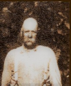
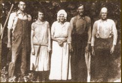
| Description | : | John Russell Cooper was the son of William "Billy" Cornelius and Mary "Polly" Banks Warner Cooper who moved from South Carolina to what is now Graham County in the early 1800's. John moved on to Cades Cove before 1850 and on December 28, 1884 he married Margaret Rowan, daughter of early settlers George Washington and Sarah "Sallie" Davis Rowan. John Russell and Margaret had several children before she died about 1866: Swinton Bennett who married Sarah Stratton, Sarah "Sally" Jane who married Albert Nichols, Dorcas Tennessee who married William Harve Elliott, Margaret Melvina who married William I. LeQuire, and Mary... Read More |
frequently asked questions (FAQ):
-
Where is John Russell Cooper's memorial?
John Russell Cooper's memorial is located at: Harrell Cemetery, Bean Station, Grainger County, USA.
-
When did John Russell Cooper death?
John Russell Cooper death on 15 Aug 1890 in Cades Cove, Blount County, Tennessee, USA
-
Where are the coordinates of the John Russell Cooper's memorial?
Latitude: 36.3074989
Longitude: -83.3463974
Family Members:
Parent
Spouse

Children
Flowers:


Nearby Cemetories:
1. Harrell Cemetery
Bean Station, Grainger County, USA
Coordinate: 36.3074989, -83.3463974
2. Marys Chapel Cemetery
Grainger County, USA
Coordinate: 36.3011017, -83.3569031
3. Noeton Baptist Church Cemetery Original
Bean Station, Grainger County, USA
Coordinate: 36.3012600, -83.3342200
4. Harris Cemetery
Grainger County, USA
Coordinate: 36.3055992, -83.3308029
5. Cobb Cemetery
Grainger County, USA
Coordinate: 36.3189011, -83.3644028
6. Heath Chapel Cemetery
Grainger County, USA
Coordinate: 36.2851730, -83.3615220
7. Bean Station Cemetery
Bean Station, Grainger County, USA
Coordinate: 36.3283000, -83.3697000
8. Buck Hollow Cemetery
Grainger County, USA
Coordinate: 36.3344120, -83.3589440
9. Ford Cemetery
Grainger County, USA
Coordinate: 36.2902985, -83.3071976
10. Lakeshore Missionary Baptist Church Cemetery
Bean Station, Grainger County, USA
Coordinate: 36.2797470, -83.3780200
11. Dalton Cemetery
Bean Station, Grainger County, USA
Coordinate: 36.3428001, -83.3296967
12. Macedonia Missionary Baptist Church Cemetery
Morristown, Hamblen County, USA
Coordinate: 36.2696100, -83.3301400
13. Holston Baptist Church Cemetery
Bean Station, Grainger County, USA
Coordinate: 36.2775002, -83.3796997
14. Samsel Cemetery
Bean Station, Grainger County, USA
Coordinate: 36.3424020, -83.3167060
15. Samsel Cemetery
Bean Station, Grainger County, USA
Coordinate: 36.3114014, -83.2925034
16. Freedom Chapel Missionary Baptist Church Cemetery
Grainger County, USA
Coordinate: 36.2865410, -83.3948480
17. Garrett Cemetery
Grainger County, USA
Coordinate: 36.3414001, -83.3082962
18. Helton Cemetery
Bean Station, Grainger County, USA
Coordinate: 36.2910995, -83.3993988
19. Samsel Lakeview Cemetery
Bean Station, Grainger County, USA
Coordinate: 36.3475800, -83.3189468
20. Adriel Baptist Church Cemetery
Bean Station, Grainger County, USA
Coordinate: 36.3125000, -83.2897034
21. Helton Cemetery
Bean Station, Grainger County, USA
Coordinate: 36.3451190, -83.3831290
22. Dodson Cemetery
Bean Station, Grainger County, USA
Coordinate: 36.2989006, -83.2869034
23. Taylor Family Cemetery
Bean Station, Grainger County, USA
Coordinate: 36.2876670, -83.2907330
24. First Independent Freewill Baptist Church Cemetery
Bean Station, Grainger County, USA
Coordinate: 36.3158860, -83.2855850