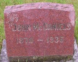
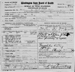
John William McDaniels
| Birth | : | 24 Dec 1878 Redbird, Holt County, Nebraska, USA |
| Death | : | 5 Dec 1936 Vancouver, Clark County, Washington, USA |
| Burial | : | St. Nicholas' Churchyard, West Tanfield, Hambleton District, England |
| Coordinate | : | 54.2036840, -1.5906360 |
| Description | : | John was the third of nine children born to Daniel Nathan and Clara Brown. |
frequently asked questions (FAQ):
-
Where is John William McDaniels's memorial?
John William McDaniels's memorial is located at: St. Nicholas' Churchyard, West Tanfield, Hambleton District, England.
-
When did John William McDaniels death?
John William McDaniels death on 5 Dec 1936 in Vancouver, Clark County, Washington, USA
-
Where are the coordinates of the John William McDaniels's memorial?
Latitude: 54.2036840
Longitude: -1.5906360
Family Members:
Parent
Siblings
Flowers:
Nearby Cemetories:
1. St. Nicholas' Churchyard
West Tanfield, Hambleton District, England
Coordinate: 54.2036840, -1.5906360
2. West Tanfield Methodist Chapelyard
West Tanfield, Hambleton District, England
Coordinate: 54.2065210, -1.5904340
3. St John the Evangelist Churchyard
Mickley, Harrogate Borough, England
Coordinate: 54.1878300, -1.6117000
4. St Mary the Virgin Churchyard
North Stainley, Harrogate Borough, England
Coordinate: 54.1881600, -1.5627900
5. St Michael Churchyard
Well, Hambleton District, England
Coordinate: 54.2334600, -1.5900500
6. St James Churchyard
Grewelthorpe, Harrogate Borough, England
Coordinate: 54.1822150, -1.6487290
7. St. Mary the Virgin Churchyard
Masham, Harrogate Borough, England
Coordinate: 54.2212500, -1.6538320
8. St. Andrew's Churchyard
Kirkby Malzeard, Harrogate Borough, England
Coordinate: 54.1658250, -1.6410510
9. St Michael Churchyard
Kirklington, Hambleton District, England
Coordinate: 54.2242770, -1.5126140
10. Norton Conyers Pet Cemetery
Ripon, Harrogate Borough, England
Coordinate: 54.1814050, -1.5131410
11. St Mary Chapel
Snape, Hambleton District, England
Coordinate: 54.2543950, -1.5991040
12. St. Mary's Chapel Snape Castle
Snape, Hambleton District, England
Coordinate: 54.2544470, -1.5991790
13. Kirkby Malzeard Cemetery
Kirkby Malzeard, Harrogate Borough, England
Coordinate: 54.1603370, -1.6420850
14. St. Mary's Churchyard
Wath, Harrogate Borough, England
Coordinate: 54.1889990, -1.5032490
15. Thorp Perrow Pet Cemetery
Bedale, Hambleton District, England
Coordinate: 54.2631350, -1.6050920
16. Lark Hill Cemetery
Ripon, Harrogate Borough, England
Coordinate: 54.1454600, -1.5422800
17. St Lambert Churchyard
Burneston, Hambleton District, England
Coordinate: 54.2592940, -1.5273040
18. St Mary Churchyard
Thornton Watlass, Hambleton District, England
Coordinate: 54.2627000, -1.6445300
19. St. Cuthbert and St. Oswald Churchyard
Winksley, Harrogate Borough, England
Coordinate: 54.1366080, -1.6150270
20. Ripon Cemetery
Ripon, Harrogate Borough, England
Coordinate: 54.1418130, -1.5357040
21. Low Ellington Friends Burial Ground
Harrogate Borough, England
Coordinate: 54.2488730, -1.6896440
22. Chapel of Resurrection
Laverton, Harrogate Borough, England
Coordinate: 54.1469500, -1.6713100
23. Holy Trinity Churchyard
Ripon, Harrogate Borough, England
Coordinate: 54.1378700, -1.5283900
24. Temple Gardens
Ripon, Harrogate Borough, England
Coordinate: 54.1386070, -1.5229240

