
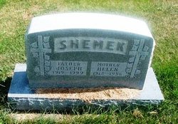
Joseph A. Shemek
| Birth | : | 19 Mar 1919 Tarnov, Platte County, Nebraska, USA |
| Death | : | 4 Jul 1999 Madison, Madison County, Nebraska, USA |
| Burial | : | Fleetwood Cemetery, Fleetwood, Wyre Borough, England |
| Coordinate | : | 53.9223440, -3.0370570 |
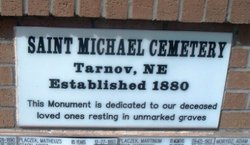
| Description | : | Son of Ignacy "James" & Sophia (Chohon) Shemek. Last name is also spelled SIEMEK. Married to Helen Hanzel on 1-27-1948. ---------------------------------------- Served in the U. S. Army during World War II from September 1942 to December 1945. Received the American Service Medal, Philippine Liberation Ribbon, World War II Victory Medal and Good Conduct Medal. Following his service, he returned to Tarnov and farmed. Survived by a daughter, Bonnie, and a son, Eugene. Contributor: diaNEB (47466150) |
frequently asked questions (FAQ):
-
Where is Joseph A. Shemek's memorial?
Joseph A. Shemek's memorial is located at: Fleetwood Cemetery, Fleetwood, Wyre Borough, England.
-
When did Joseph A. Shemek death?
Joseph A. Shemek death on 4 Jul 1999 in Madison, Madison County, Nebraska, USA
-
Where are the coordinates of the Joseph A. Shemek's memorial?
Latitude: 53.9223440
Longitude: -3.0370570
Family Members:
Parent

Spouse

Siblings

Flowers:


Nearby Cemetories:
1. Fleetwood Cemetery
Fleetwood, Wyre Borough, England
Coordinate: 53.9223440, -3.0370570
2. St. Peter and St. David Churchyard
Fleetwood, Wyre Borough, England
Coordinate: 53.9238123, -3.0116212
3. Preesall Cemetery
Preesall, Wyre Borough, England
Coordinate: 53.9075410, -2.9635410
4. Christ Church Thornton Churchyard
Thornton-Cleveleys, Wyre Borough, England
Coordinate: 53.8772800, -3.0221100
5. St James Churchyard
Stalmine, Wyre Borough, England
Coordinate: 53.9020510, -2.9533720
6. All Hallow's Churchyard
Bispham, Blackpool Unitary Authority, England
Coordinate: 53.8567580, -3.0372160
7. St John the Baptist's Church
Pilling, Wyre Borough, England
Coordinate: 53.9289910, -2.9114540
8. St Johns Roman Catholic Church Cemetery
Poulton-le-Fylde, Wyre Borough, England
Coordinate: 53.8520854, -2.9873511
9. Blackpool Cemetery and Crematorium
Poulton-le-Fylde, Wyre Borough, England
Coordinate: 53.8465680, -3.0196600
10. Saint Chad Churchyard
Poulton-le-Fylde, Wyre Borough, England
Coordinate: 53.8471992, -2.9925005
11. St Stephen On-the-Cliffs Churchyard
Blackpool, Blackpool Unitary Authority, England
Coordinate: 53.8407230, -3.0515610
12. St William of York Church
Pilling, Wyre Borough, England
Coordinate: 53.9235047, -2.8934617
13. Poulton-Le-Fylde Old Cemetery
Poulton-le-Fylde, Wyre Borough, England
Coordinate: 53.8458145, -2.9713324
14. Poulton New Cemetery
Poulton-le-Fylde, Wyre Borough, England
Coordinate: 53.8461240, -2.9689560
15. Blackpool Jewish Cemetery
Blackpool, Blackpool Unitary Authority, England
Coordinate: 53.8287397, -3.0311753
16. St Paul's Church & Medical Centre
Blackpool Unitary Authority, England
Coordinate: 53.8291540, -3.0533490
17. Layton Cemetery
Blackpool, Blackpool Unitary Authority, England
Coordinate: 53.8273740, -3.0328240
18. St. John’s Churchyard
Out Rawcliffe, Wyre Borough, England
Coordinate: 53.8741650, -2.8959310
19. St. Anne's Churchyard
Blackburn, Blackburn with Darwen Unitary Authority, England
Coordinate: 53.8381160, -2.9362870
20. St Anne Churchyard
Singleton, Fylde Borough, England
Coordinate: 53.8379280, -2.9359890
21. St John the Evangelist Churchyard
Blackpool, Blackpool Unitary Authority, England
Coordinate: 53.8182303, -3.0508197
22. Carlton Cemetery& Crematorium
Blackpool, Blackpool Unitary Authority, England
Coordinate: 53.8095921, -3.0364920
23. St Anne Churchyard
Great Eccleston, Wyre Borough, England
Coordinate: 53.8481413, -2.8835925
24. Saint Paul Churchyard
Great Marton, Blackpool Unitary Authority, England
Coordinate: 53.8053220, -3.0268330