
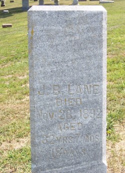
Joseph Bloomfield “J.B.” Lane
| Birth | : | 8 Apr 1830 Ocean County, New Jersey, USA |
| Death | : | 26 Nov 1892 Osceola, Clarke County, Iowa, USA |
| Burial | : | Holy Trinity Churchyard, Burnley, Burnley Borough, England |
| Coordinate | : | 53.7898290, -2.2574200 |
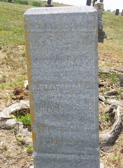
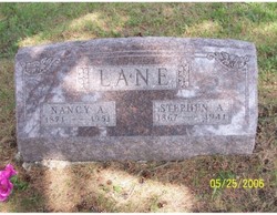
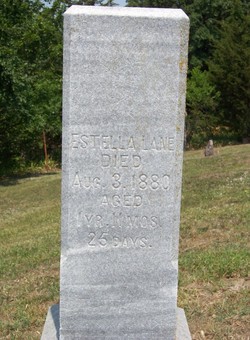
| Description | : | Plot #05-02 Son of Richard Lane and Annie M. Holmes. His father was a fisherman and was lost at sea about December 1830. His mother died in 1852 in Highland Co, OH. J.B. had a twin brother, George W. Lane. J.B. married Edith "Eda" Harlan #6227[daughter of Aaron Harlan #2483 and Jemima Polly] on 7 March 1856 in Clarke Co, IA. Their children were William "Edgar" Lane, Miriam Celesta "Lestie" Lane[married Charles Chandler], Nancy Catherine Lane[married French Festavus Van Scoy], George Washington Lane[married Jenny DeArc Farley], Stephen "Azro" Lane[married Nancy Augusta "Gusta" Harris], Maryann "Rhoda" Lane[married Charles Newman] and Clara "Estella" Lane[buried... Read More |
frequently asked questions (FAQ):
-
Where is Joseph Bloomfield “J.B.” Lane's memorial?
Joseph Bloomfield “J.B.” Lane's memorial is located at: Holy Trinity Churchyard, Burnley, Burnley Borough, England.
-
When did Joseph Bloomfield “J.B.” Lane death?
Joseph Bloomfield “J.B.” Lane death on 26 Nov 1892 in Osceola, Clarke County, Iowa, USA
-
Where are the coordinates of the Joseph Bloomfield “J.B.” Lane's memorial?
Latitude: 53.7898290
Longitude: -2.2574200
Family Members:
Spouse
Children
Flowers:


Nearby Cemetories:
1. Holy Trinity Churchyard
Burnley, Burnley Borough, England
Coordinate: 53.7898290, -2.2574200
2. St. James' Churchyard
Burnley, Burnley Borough, England
Coordinate: 53.7905590, -2.2458280
3. St. Peter's Churchyard
Burnley, Burnley Borough, England
Coordinate: 53.7924450, -2.2394890
4. Ebenezer Baptist Chapel Chapelyard
Burnley, Burnley Borough, England
Coordinate: 53.7975120, -2.2397260
5. Burnley Cemetery
Burnley, Burnley Borough, England
Coordinate: 53.7821730, -2.2795070
6. Burnley Crematorium
Burnley, Burnley Borough, England
Coordinate: 53.7821730, -2.2795070
7. All Saints Churchyard
Habergham Eaves, Burnley Borough, England
Coordinate: 53.7971060, -2.2913770
8. St. John's Cemetery
Padiham, Burnley Borough, England
Coordinate: 53.7948720, -2.3145290
9. St Margaret Churchyard
Hapton, Burnley Borough, England
Coordinate: 53.7802400, -2.3169230
10. St. Leonard's Churchyard
Padiham, Burnley Borough, England
Coordinate: 53.8022600, -2.3164300
11. Wesleyan Methodist Chapel Chapelyard
Padiham, Burnley Borough, England
Coordinate: 53.8018980, -2.3181730
12. St. James' Churchyard
Briercliffe, Burnley Borough, England
Coordinate: 53.8107700, -2.2031800
13. St Leonard Churchyard Extension
Padiham, Burnley Borough, England
Coordinate: 53.7991800, -2.3222000
14. St John Churchyard
Higham, Pendle Borough, England
Coordinate: 53.8251420, -2.2898120
15. St. John the Evangelist Churchyard
Worsthorne, Burnley Borough, England
Coordinate: 53.7877640, -2.1887420
16. Marsden Friends Burial Ground
Marsden, Metropolitan Borough of Kirklees, England
Coordinate: 53.8241910, -2.2197410
17. St. Anne Churchyard
Fence, Pendle Borough, England
Coordinate: 53.8304372, -2.2679552
18. Haggate Baptist Church Burial Ground
Burnley Borough, England
Coordinate: 53.8145048, -2.1960725
19. Wheatley Lane Methodist Churchyard
Fence, Pendle Borough, England
Coordinate: 53.8341457, -2.2596202
20. St. Paul's Churchyard
Nelson, Pendle Borough, England
Coordinate: 53.8289250, -2.2157520
21. Providence Free United Methodist Graveyard
Crawshawbooth, Rossendale Borough, England
Coordinate: 53.7442070, -2.2825700
22. Hill Lane Baptist Church Churchyard
Briercliffe, Burnley Borough, England
Coordinate: 53.8161467, -2.1875368
23. Wheatley Lane Inghamite Church Churchyard
Wheatley Lane, Pendle Borough, England
Coordinate: 53.8412800, -2.2457100
24. St James Church
Altham, Hyndburn Borough, England
Coordinate: 53.7928940, -2.3465250