
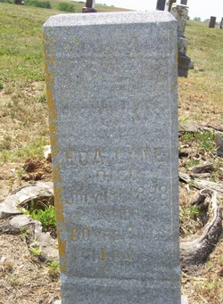
Edith “Eda” Harlan Lane
| Birth | : | 4 Nov 1837 Kosciusko County, Indiana, USA |
| Death | : | 19 Jul 1898 Osceola, Clarke County, Iowa, USA |
| Burial | : | Holy Trinity Churchyard, Burnley, Burnley Borough, England |
| Coordinate | : | 53.7898290, -2.2574200 |
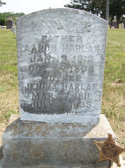
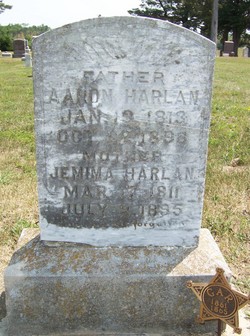
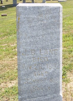
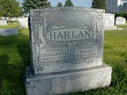
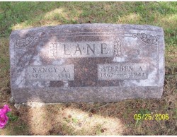
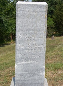
| Description | : | Plot #05-02 Daughter of Aaron Harlan #2483 and Jemima Polly. She married Joseph Bloomfield "J.B." Lane on 7 March 1856 in Clarke Co, IA. Their children were William "Edgar" Lane, Mirian Celesta "Lestie" Lane[married Charles Chandler], Nancy Catherine Lane[married French Festavus Van Scoy], George Washington Lane[married Jennie DeArc Farley], Stephen Azro Lane[married Nancy Augusta "Gusta" Harris], Maryann "Rhoda" Lane[married Charles Newman] and Clara "Estella" Lane. Eda died age 60 years 8 months and 11 days. Eda and J.B. Lane are buried beside daughter Estella Lane. In same row are her brother Aaron W. Harlan and his son Frank, as well as Eda's parents, Aaron and... Read More |
frequently asked questions (FAQ):
-
Where is Edith “Eda” Harlan Lane's memorial?
Edith “Eda” Harlan Lane's memorial is located at: Holy Trinity Churchyard, Burnley, Burnley Borough, England.
-
When did Edith “Eda” Harlan Lane death?
Edith “Eda” Harlan Lane death on 19 Jul 1898 in Osceola, Clarke County, Iowa, USA
-
Where are the coordinates of the Edith “Eda” Harlan Lane's memorial?
Latitude: 53.7898290
Longitude: -2.2574200
Family Members:
Parent
Spouse
Siblings

Children
Flowers:


Nearby Cemetories:
1. Holy Trinity Churchyard
Burnley, Burnley Borough, England
Coordinate: 53.7898290, -2.2574200
2. St. James' Churchyard
Burnley, Burnley Borough, England
Coordinate: 53.7905590, -2.2458280
3. St. Peter's Churchyard
Burnley, Burnley Borough, England
Coordinate: 53.7924450, -2.2394890
4. Ebenezer Baptist Chapel Chapelyard
Burnley, Burnley Borough, England
Coordinate: 53.7975120, -2.2397260
5. Burnley Cemetery
Burnley, Burnley Borough, England
Coordinate: 53.7821730, -2.2795070
6. Burnley Crematorium
Burnley, Burnley Borough, England
Coordinate: 53.7821730, -2.2795070
7. All Saints Churchyard
Habergham Eaves, Burnley Borough, England
Coordinate: 53.7971060, -2.2913770
8. St. John's Cemetery
Padiham, Burnley Borough, England
Coordinate: 53.7948720, -2.3145290
9. St Margaret Churchyard
Hapton, Burnley Borough, England
Coordinate: 53.7802400, -2.3169230
10. St. Leonard's Churchyard
Padiham, Burnley Borough, England
Coordinate: 53.8022600, -2.3164300
11. Wesleyan Methodist Chapel Chapelyard
Padiham, Burnley Borough, England
Coordinate: 53.8018980, -2.3181730
12. St. James' Churchyard
Briercliffe, Burnley Borough, England
Coordinate: 53.8107700, -2.2031800
13. St Leonard Churchyard Extension
Padiham, Burnley Borough, England
Coordinate: 53.7991800, -2.3222000
14. St John Churchyard
Higham, Pendle Borough, England
Coordinate: 53.8251420, -2.2898120
15. St. John the Evangelist Churchyard
Worsthorne, Burnley Borough, England
Coordinate: 53.7877640, -2.1887420
16. Marsden Friends Burial Ground
Marsden, Metropolitan Borough of Kirklees, England
Coordinate: 53.8241910, -2.2197410
17. St. Anne Churchyard
Fence, Pendle Borough, England
Coordinate: 53.8304372, -2.2679552
18. Haggate Baptist Church Burial Ground
Burnley Borough, England
Coordinate: 53.8145048, -2.1960725
19. Wheatley Lane Methodist Churchyard
Fence, Pendle Borough, England
Coordinate: 53.8341457, -2.2596202
20. St. Paul's Churchyard
Nelson, Pendle Borough, England
Coordinate: 53.8289250, -2.2157520
21. Providence Free United Methodist Graveyard
Crawshawbooth, Rossendale Borough, England
Coordinate: 53.7442070, -2.2825700
22. Hill Lane Baptist Church Churchyard
Briercliffe, Burnley Borough, England
Coordinate: 53.8161467, -2.1875368
23. Wheatley Lane Inghamite Church Churchyard
Wheatley Lane, Pendle Borough, England
Coordinate: 53.8412800, -2.2457100
24. St James Church
Altham, Hyndburn Borough, England
Coordinate: 53.7928940, -2.3465250