

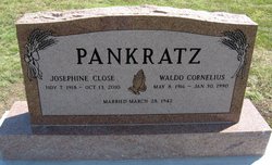
Josephine Rebecca Close Pankratz
| Birth | : | 7 Nov 1918 Ford County, Kansas, USA |
| Death | : | 13 Oct 2010 Newton, Harvey County, Kansas, USA |
| Burial | : | All Saints Churchyard, Denstone, East Staffordshire Borough, England |
| Plot | : | Block H, Lot 103, N1/2 |
| Description | : | NEWTON - Pankratz, Josephine R., died October 13, 2010 at Presbyterian Manor in Newton, Kan. She is survived by her three sons and their spouses: Mike Pankratz (Cynthia) of Vashon, Wash., Tim Pankratz (Martha) of Tuscon, Ariz., and Randy Pankratz (Charlotte) of Newton; by grandchildren Ben Oleson of Seattle, Mary and Michael Pankratz of Tucson, and Lily Pankratz of Topeka, by sisters, Charyl Strandt of Milwaukie, Ore., Myrna Lucas of Johnson, Kan., and Delva Butts of Mulvane; and one brother, Ercel Close of Kingsdown, Kan. She was predeceased in 1990 by her husband of 47 years, Waldo C. Pankratz, by... Read More |
frequently asked questions (FAQ):
-
Where is Josephine Rebecca Close Pankratz's memorial?
Josephine Rebecca Close Pankratz's memorial is located at: All Saints Churchyard, Denstone, East Staffordshire Borough, England.
-
When did Josephine Rebecca Close Pankratz death?
Josephine Rebecca Close Pankratz death on 13 Oct 2010 in Newton, Harvey County, Kansas, USA
Family Members:
Parent

Spouse
Siblings
Flowers:


Nearby Cemetories:
1. St. Leonard's Churchyard
Blithfield, East Staffordshire Borough, England
Coordinate: 52.8465144, -1.6519844
2. Saint Peter's Cemetery
Ellastone, East Staffordshire Borough, England
3. All Saints Churchyard
Leigh, East Staffordshire Borough, England
Coordinate: 52.7809957, -1.7236464
4. All Saints Churchyard
Rangemore, East Staffordshire Borough, England
Coordinate: 52.7958170, -1.6968150
5. Needwood, Christchurch
Tutbury, East Staffordshire Borough, England
Coordinate: 52.8963900, -1.9106400
6. Priory Church of St. Mary the Virgin
Tutbury, East Staffordshire Borough, England
7. St. James' Churchyard
Barton-under-Needwood, East Staffordshire Borough, England
Coordinate: 52.8630944, -1.9115108
8. RAF Fauld
Hanbury, East Staffordshire Borough, England
Coordinate: 53.0302050, -1.7650989
9. St Mary Churchyard
Hanbury, East Staffordshire Borough, England
Coordinate: 52.7960899, -1.6230323
10. St Werburgh's Church
Hanbury, East Staffordshire Borough, England
Coordinate: 52.8987700, -1.8624100
11. St John Churchyard
Marchington Woodlands, East Staffordshire Borough, England
12. Rolleston Cemetery
Rolleston-on-Dove, East Staffordshire Borough, England
13. St. Mary's Churchyard
Rolleston-on-Dove, East Staffordshire Borough, England
Coordinate: 52.8465144, -1.6519844
14. Chapelry of Tatenhill
Tatenhill, East Staffordshire Borough, England
15. St. Mary's Churchyard, Dunstall
Tatenhill, East Staffordshire Borough, England
Coordinate: 52.7809957, -1.7236464
16. St. Michael and All Angels Churchyard
Tatenhill, East Staffordshire Borough, England
Coordinate: 52.7958170, -1.6968150
17. St Lawrence Churchyard
Bramshall, East Staffordshire Borough, England
Coordinate: 52.8963900, -1.9106400
18. All Saints Churchyard
Denstone, East Staffordshire Borough, England
19. St. John the Baptist Churchyard
Kingstone, East Staffordshire Borough, England
Coordinate: 52.8630944, -1.9115108
20. All Saints Church
Okeover, East Staffordshire Borough, England
Coordinate: 53.0302050, -1.7650989
21. St. Peter's Parish Churchyard
Stapenhill, East Staffordshire Borough, England
Coordinate: 52.7960899, -1.6230323
22. Saint Mary the Virgin Churchyard
Uttoxeter, East Staffordshire Borough, England
Coordinate: 52.8987700, -1.8624100
23. St Lawrence Churchyard
Uttoxeter, East Staffordshire Borough, England
24. Uttoxeter Cemetery
Uttoxeter, East Staffordshire Borough, England