
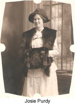
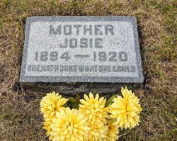

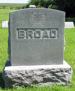
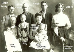
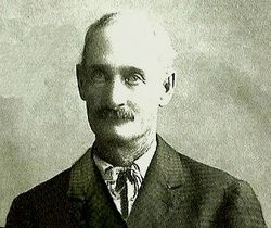
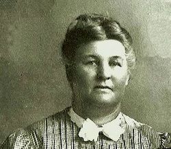
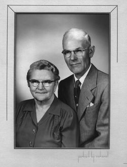
Josie Purdy Broad
| Birth | : | 4 Mar 1894 Spring Creek Township, Black Hawk County, Iowa, USA |
| Death | : | 14 Feb 1920 Spring Creek Township, Black Hawk County, Iowa, USA |
| Burial | : | Colored Asylum Cemetery, Columbia, Richland County, USA |
| Coordinate | : | 34.0244050, -81.0220490 |
| Description | : | THE EVENING COURIER AND REPORTER. WATERLOO. IOWA. TUESDAY, FEBRUARY 17, 1920 Pg 10 La Porte City, Feb. 17.—The death of Mrs. Fred Broad occurred shortly after 2 o'clock Saturday afternoon [Feb 14, 1920], at her home in Spring Creek township eight miles northeast of this city. About 10 days ago she was stricken by the "flu" and within a short time pneumonia developed, and not withstanding the best effort of medical skill and faithful ministrations of loved ones, she passed away. In the death of Mrs. Broad the community mourns with the sadly bereft young husband and the parents... Read More |
frequently asked questions (FAQ):
-
Where is Josie Purdy Broad's memorial?
Josie Purdy Broad's memorial is located at: Colored Asylum Cemetery, Columbia, Richland County, USA.
-
When did Josie Purdy Broad death?
Josie Purdy Broad death on 14 Feb 1920 in Spring Creek Township, Black Hawk County, Iowa, USA
-
Where are the coordinates of the Josie Purdy Broad's memorial?
Latitude: 34.0244050
Longitude: -81.0220490
Family Members:
Parent
Spouse
Siblings
Children

Flowers:


Nearby Cemetories:
1. Colored Asylum Cemetery
Columbia, Richland County, USA
Coordinate: 34.0244050, -81.0220490
2. Barhamville Cemetery
Columbia, Richland County, USA
Coordinate: 34.0236870, -81.0107570
3. Crescent Hill Memorial Gardens and Mausoleum
Columbia, Richland County, USA
Coordinate: 34.0297012, -81.0089035
4. Geiger Avenue Cemetery
Columbia, Richland County, USA
Coordinate: 34.0228050, -81.0394590
5. Lincoln Cemetery
Columbia, Richland County, USA
Coordinate: 34.0400009, -81.0214005
6. Miller Cemetery
Columbia, Richland County, USA
Coordinate: 34.0321999, -81.0391998
7. Saint Lukes Episcopal Church Memorial Garden
Columbia, Richland County, USA
Coordinate: 34.0082060, -81.0180940
8. Church of the Good Shepherd Memorial Gardens
Columbia, Richland County, USA
Coordinate: 34.0096610, -81.0316160
9. Ebenezer Lutheran Church Cemetery
Columbia, Richland County, USA
Coordinate: 34.0113680, -81.0361220
10. Mount Pleasant United Methodist Church Cemetery
Columbia, Richland County, USA
Coordinate: 34.0101996, -81.0350037
11. First Baptist Church Cemetery
Columbia, Richland County, USA
Coordinate: 34.0062460, -81.0321850
12. First Presbyterian Churchyard
Columbia, Richland County, USA
Coordinate: 34.0041110, -81.0293900
13. Gunter's Chapel Baptist Church Cemetery
Columbia, Richland County, USA
Coordinate: 34.0394590, -81.0028790
14. Saint Peter's Catholic Church Cemetery
Columbia, Richland County, USA
Coordinate: 34.0052900, -81.0384100
15. Douglass Cemetery
Columbia, Richland County, USA
Coordinate: 34.0180340, -81.0492810
16. Saint Peter's Cemetery
Columbia, Richland County, USA
Coordinate: 34.0119200, -81.0488700
17. Hebrew Benevolent Society Cemetery
Columbia, Richland County, USA
Coordinate: 34.0049780, -81.0435680
18. Elmwood Memorial Gardens
Columbia, Richland County, USA
Coordinate: 34.0121000, -81.0523200
19. Promised Land Cemetery
Columbia, Richland County, USA
Coordinate: 34.0423830, -80.9960170
20. Eastminster Presbyterian Church Columbarium
Columbia, Richland County, USA
Coordinate: 34.0079530, -80.9942360
21. Palmetto Cemetery
Columbia, Richland County, USA
Coordinate: 34.0521785, -81.0290293
22. Antioch Baptist Church Cemetery
Columbia, Richland County, USA
Coordinate: 34.0525790, -81.0114780
23. Randolph Cemetery
Columbia, Richland County, USA
Coordinate: 34.0093500, -81.0540800
24. Pine Ridge Cemetery
Columbia, Richland County, USA
Coordinate: 34.0539017, -81.0124969