
| Birth | : | 4 Sep 1899 Barneston, Gage County, Nebraska, USA |
| Death | : | 22 Mar 1978 Beattie, Marshall County, Kansas, USA |
| Burial | : | West Cemetery, Princeton, Worcester County, USA |
| Coordinate | : | 42.4454100, -71.9256500 |
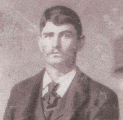
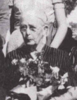
| Description | : | married Maurice O'Neil Oct 10, 1928. survived by 2 sons. |
frequently asked questions (FAQ):
-
Where is Julia Kathryn Alders O'Neil's memorial?
Julia Kathryn Alders O'Neil's memorial is located at: West Cemetery, Princeton, Worcester County, USA.
-
When did Julia Kathryn Alders O'Neil death?
Julia Kathryn Alders O'Neil death on 22 Mar 1978 in Beattie, Marshall County, Kansas, USA
-
Where are the coordinates of the Julia Kathryn Alders O'Neil's memorial?
Latitude: 42.4454100
Longitude: -71.9256500
Family Members:
Parent
Spouse

Siblings
Children
Flowers:


Nearby Cemetories:
1. West Cemetery
Princeton, Worcester County, USA
Coordinate: 42.4454100, -71.9256500
2. Woodlawn Cemetery
Princeton, Worcester County, USA
Coordinate: 42.4447260, -71.8835880
3. Meetinghouse Cemetery
Princeton, Worcester County, USA
Coordinate: 42.4551600, -71.8823000
4. South Burying Ground
Princeton, Worcester County, USA
Coordinate: 42.4192009, -71.8957977
5. Boylston Burial Ground
Princeton, Worcester County, USA
Coordinate: 42.4490700, -71.8787000
6. Clark Cemetery
Hubbardston, Worcester County, USA
Coordinate: 42.4840900, -71.9587800
7. Smith Family Cemetery
Rutland, Worcester County, USA
Coordinate: 42.3946064, -71.9231169
8. North Cemetery
Princeton, Worcester County, USA
Coordinate: 42.4797700, -71.8724000
9. Evergreen Cemetery
Hubbardston, Worcester County, USA
Coordinate: 42.4630750, -71.9974320
10. Route 62 Cemetery
Hubbardston, Worcester County, USA
Coordinate: 42.4426910, -72.0014980
11. Rural Glen Cemetery
Hubbardston, Worcester County, USA
Coordinate: 42.4653015, -71.9985962
12. Brookside Cemetery
Hubbardston, Worcester County, USA
Coordinate: 42.4662700, -71.9993400
13. Parker II Cemetery
Princeton, Worcester County, USA
Coordinate: 42.4451900, -71.8370600
14. Parker I Cemetery
Princeton, Worcester County, USA
Coordinate: 42.4828500, -71.8529500
15. Parish Cemetery
Hubbardston, Worcester County, USA
Coordinate: 42.4754140, -72.0054840
16. Goose Hill Cemetery
Rutland, Worcester County, USA
Coordinate: 42.3997400, -71.9914000
17. Pine Grove Cemetery
Hubbardston, Worcester County, USA
Coordinate: 42.4653015, -72.0119019
18. Greenwood Cemetery
Hubbardston, Worcester County, USA
Coordinate: 42.4984700, -71.9812300
19. Rutland Prison Camp Cemetery
Rutland, Worcester County, USA
Coordinate: 42.3988500, -71.9923800
20. Rutland Rural Cemetery
Rutland, Worcester County, USA
Coordinate: 42.3790100, -71.9447500
21. Old Burial Ground
Rutland, Worcester County, USA
Coordinate: 42.3756000, -71.9578000
22. Parker Cemetery
Barre, Worcester County, USA
Coordinate: 42.4250800, -72.0240400
23. Lovewell Cemetery
Hubbardston, Worcester County, USA
Coordinate: 42.4961900, -72.0096100
24. Forest Hill Cemetery
Hubbardston, Worcester County, USA
Coordinate: 42.4763985, -72.0361023