
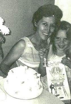

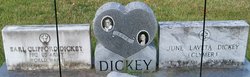
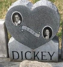
June Laveta Clymer Dickey
| Birth | : | 5 Oct 1924 Colorado, USA |
| Death | : | 30 Jun 1985 St. Francois County, Missouri, USA |
| Burial | : | Mountain View Baptist Church Cemetery, Lowgap, Surry County, USA |
| Coordinate | : | 36.5197420, -80.8645570 |
| Description | : | June died of cancer at Mineral Area osteopathic Hospital at the age of 60 of cancer. (Two months after her husband died of cancer). She was born in Loveland Col. She was preceded in death by her father, Murl Samuel Clymer and her husband earl Clifford Dickey. She is survived by her mother, Esther Blanche Beabout Clymer Hedicke Skaggs of Fredericktown, Mo. three daugghters, Earlean (Mrs. David) Lietz of Route 4, Farmington, Mrs Beverly Sellers of Delassus and and tina (Mrs Ron) Tiefenauer of the USAF in West Germany, and three sons, Paul E. Dickey, of Farmington, Terry L.... Read More |
frequently asked questions (FAQ):
-
Where is June Laveta Clymer Dickey's memorial?
June Laveta Clymer Dickey's memorial is located at: Mountain View Baptist Church Cemetery, Lowgap, Surry County, USA.
-
When did June Laveta Clymer Dickey death?
June Laveta Clymer Dickey death on 30 Jun 1985 in St. Francois County, Missouri, USA
-
Where are the coordinates of the June Laveta Clymer Dickey's memorial?
Latitude: 36.5197420
Longitude: -80.8645570
Family Members:
Spouse
Children
Flowers:


Nearby Cemetories:
1. Mountain View Baptist Church Cemetery
Lowgap, Surry County, USA
Coordinate: 36.5197420, -80.8645570
2. Liberty Union Baptist Cemetery
Lowgap, Surry County, USA
Coordinate: 36.5273056, -80.8688583
3. Fishers Gap Church Cemetery
Lowgap, Surry County, USA
Coordinate: 36.5231400, -80.8833923
4. Galyean Family Cemetery
Lowgap, Surry County, USA
Coordinate: 36.5346140, -80.8703660
5. Shinault Family Cemetery
Lowgap, Surry County, USA
Coordinate: 36.5333640, -80.8758540
6. Cockerham Family Cemetery
Lowgap, Surry County, USA
Coordinate: 36.5284720, -80.8465830
7. Roaring Gap Baptist Church Cemetery
Lowgap, Surry County, USA
Coordinate: 36.5101929, -80.8920288
8. Barker Graveyard
Lowgap, Surry County, USA
Coordinate: 36.5295540, -80.8340600
9. Mount Vernon Baptist Church Cemetery
Beulah, Surry County, USA
Coordinate: 36.5003624, -80.8213882
10. Montgomery Cemetery
Surry County, USA
Coordinate: 36.5439722, -80.8204722
11. Ladonia Baptist Church Cemetery
Ladonia, Surry County, USA
Coordinate: 36.4780280, -80.8386670
12. Cumberland Knob Cemetery
Surry County, USA
Coordinate: 36.5535100, -80.9073400
13. Goodson Cemetery
Grayson County, USA
Coordinate: 36.5688900, -80.8611200
14. Jarrell Family Cemetery
Lowgap, Surry County, USA
Coordinate: 36.5427860, -80.8103660
15. Smith Family Cemetery
Grayson County, USA
Coordinate: 36.5701930, -80.8726180
16. Low Family Cemetery
Lowgap, Surry County, USA
Coordinate: 36.5461430, -80.7985910
17. Dillard Family Cemetery
Lowgap, Surry County, USA
Coordinate: 36.5500298, -80.8002243
18. Saddle Mountain Baptist Church Cemetery
Ennice, Alleghany County, USA
Coordinate: 36.5082300, -80.9386300
19. Payne Cemetery
Lowgap, Surry County, USA
Coordinate: 36.4947220, -80.7928060
20. Round Peak Primitive Baptist Church Cemetery
Round Peak, Surry County, USA
Coordinate: 36.5145264, -80.7861633
21. Holder Cemetery
Lowgap, Surry County, USA
Coordinate: 36.5364670, -80.7875720
22. Isaacks Family Cemetery
Mount Airy, Surry County, USA
Coordinate: 36.4621670, -80.8236670
23. Sarah Isaacs Cemetery
Franklin, Surry County, USA
Coordinate: 36.4636110, -80.8205830
24. Fairview Memorial Gardens
Low Gap, Grayson County, USA
Coordinate: 36.5784080, -80.9056970