
| Birth | : | 31 Aug 1895 Emerson, Mills County, Iowa, USA |
| Death | : | 1 Jun 1956 Mills County, Iowa, USA |
| Burial | : | East Liberty Cemetery, Malvern, Mills County, USA |
| Coordinate | : | 41.0592346, -95.6005020 |
| Inscription | : | PFC HQ DET 3 AMMO TRAIN WORLD WAR I |
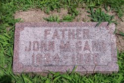
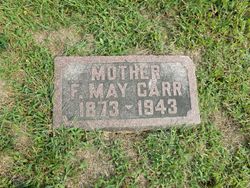
| Description | : | HEART AILMENT IS FATAL TO KARL CARR, 60 Karl Monroe Carr, son of John and May Carr, was born on a farm near Emerson, August 31, 1895 and passed away June 1, at the age of 60. He was a veteran of World War 1, serving 14 months in the Armed Forces, eleven months of he tie was with the Army of Occupation in France and Germany. On August 24, 1921, he was united in marriage to Mary Winifred Seaton. To this union two sons and two daughters were born. One daughter, Anna Lee, died in infancy. His wife, Mary,... Read More |
frequently asked questions (FAQ):
-
Where is Karl Monroe Carr's memorial?
Karl Monroe Carr's memorial is located at: East Liberty Cemetery, Malvern, Mills County, USA.
-
When did Karl Monroe Carr death?
Karl Monroe Carr death on 1 Jun 1956 in Mills County, Iowa, USA
-
Where are the coordinates of the Karl Monroe Carr's memorial?
Latitude: 41.0592346
Longitude: -95.6005020
Family Members:
Parent
Spouse

Siblings
Children
Flowers:


Nearby Cemetories:
1. East Liberty Cemetery
Malvern, Mills County, USA
Coordinate: 41.0592346, -95.6005020
2. Silver City Cemetery
Silver City, Mills County, USA
Coordinate: 41.1042442, -95.6380005
3. Wearin Cemetery
Malvern, Mills County, USA
Coordinate: 41.0395000, -95.5313000
4. Hillsdale Cemetery
Glenwood, Mills County, USA
Coordinate: 41.0097008, -95.6427994
5. Mills County Farm Cemetery
Glenwood, Mills County, USA
Coordinate: 41.0417930, -95.6756530
6. Cotten Cemetery
Mills County, USA
Coordinate: 41.0845000, -95.5167000
7. Malvern Cemetery
Malvern, Mills County, USA
Coordinate: 40.9886017, -95.5785980
8. Bomar Family Cemetery
Mills County, USA
Coordinate: 41.0369400, -95.6941700
9. Wesley Chapel Cemetery
Henderson, Mills County, USA
Coordinate: 41.1019249, -95.4987793
10. Hastings Cemetery
Hastings, Mills County, USA
Coordinate: 41.0097008, -95.4993973
11. Saylers Farm Cemetery
Henderson, Mills County, USA
Coordinate: 41.1083300, -95.4919440
12. Glenwood Resource Center Cemetery
Glenwood, Mills County, USA
Coordinate: 41.0361720, -95.7338590
13. Parker Cemetery
White Cloud, Mills County, USA
Coordinate: 40.9737649, -95.5184363
14. Mineola Cemetery
Mineola, Mills County, USA
Coordinate: 41.1391130, -95.6941800
15. Glenwood Catholic Cemetery
Glenwood, Mills County, USA
Coordinate: 41.0600000, -95.7453000
16. Glenwood Cemetery
Glenwood, Mills County, USA
Coordinate: 41.0599670, -95.7480240
17. North Grove Cemetery
Hastings, Mills County, USA
Coordinate: 41.0161018, -95.4618988
18. South Grove Cemetery
Mills County, USA
Coordinate: 40.9775009, -95.4931030
19. West Liberty Cemetery
Glenwood, Mills County, USA
Coordinate: 41.0956001, -95.7536011
20. Fairview Cemetery
Tabor, Mills County, USA
Coordinate: 40.9453011, -95.6716995
21. Saint Boniface Catholic Cemetery
Mills County, USA
Coordinate: 41.1419000, -95.7467100
22. Estes Cemetery
Tabor, Mills County, USA
Coordinate: 40.9425011, -95.7080994
23. Saar's Field Cemetery
Mills County, USA
Coordinate: 41.1255500, -95.7725000
24. Gowens-Turner Cemetery
Glenwood, Mills County, USA
Coordinate: 41.0715510, -95.7952420