


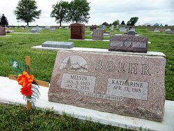

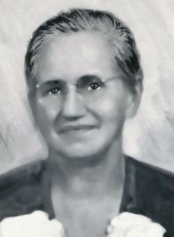
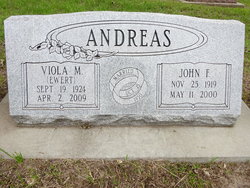
Katharine Magdalene “Kay” Andreas Boehr
| Birth | : | 13 Apr 1918 Beatrice, Gage County, Nebraska, USA |
| Death | : | 6 Jun 2016 Blair, Washington County, Nebraska, USA |
| Burial | : | First Mennonite Church Cemetery, Beatrice, Gage County, USA |
| Coordinate | : | 40.2856800, -96.8120500 |
| Plot | : | L 81 |
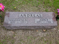
| Description | : | Katharine Magdalene "Kay" (Andreas) Boehr, 98 April 13, 1918 ~ June 6, 2016 Kay was born on April 13, 1918 in Beatrice, Nebraska, the daughter of John Paul and Magdalene (Hirschler) Andreas. She attended country school and a Bible school near Beatrice, NE. She rode her horse Flossy, carrying food and water for the horse, and sometimes racing with the other children. The Beatrice Mennonite churches worked with Russian refugees in the 1920s. In 4th grade she switched country schools so she could help a little boy who spoke Russian and German,... Read More |
frequently asked questions (FAQ):
-
Where is Katharine Magdalene “Kay” Andreas Boehr's memorial?
Katharine Magdalene “Kay” Andreas Boehr's memorial is located at: First Mennonite Church Cemetery, Beatrice, Gage County, USA.
-
When did Katharine Magdalene “Kay” Andreas Boehr death?
Katharine Magdalene “Kay” Andreas Boehr death on 6 Jun 2016 in Blair, Washington County, Nebraska, USA
-
Where are the coordinates of the Katharine Magdalene “Kay” Andreas Boehr's memorial?
Latitude: 40.2856800
Longitude: -96.8120500
Family Members:
Parent
Spouse
Siblings
Flowers:


Nearby Cemetories:
1. First Mennonite Church Cemetery
Beatrice, Gage County, USA
Coordinate: 40.2856800, -96.8120500
2. Homestead National Historical Park
Beatrice, Gage County, USA
Coordinate: 40.2864800, -96.8271100
3. Freeman Cemetery
Beatrice, Gage County, USA
Coordinate: 40.2966933, -96.8435666
4. Walnut Grove Pet Cemetery
Beatrice, Gage County, USA
Coordinate: 40.2613200, -96.7605920
5. Saint Joseph Cemetery
Beatrice, Gage County, USA
Coordinate: 40.3054700, -96.7460700
6. First Trinity Lutheran Cemetery
Beatrice, Gage County, USA
Coordinate: 40.3053600, -96.8794400
7. Dolen Cemetery
Gage County, USA
Coordinate: 40.3494950, -96.8225930
8. Beatrice Cemetery
Beatrice, Gage County, USA
Coordinate: 40.2625970, -96.7332670
9. Sparks Cemetery
Beatrice, Gage County, USA
Coordinate: 40.2485180, -96.8984970
10. Ellis Cemetery
Beatrice, Gage County, USA
Coordinate: 40.2260017, -96.8785019
11. Austin Creek Cemetery
Beatrice, Gage County, USA
Coordinate: 40.3282280, -96.7233020
12. Evergreen Home Cemetery
Beatrice, Gage County, USA
Coordinate: 40.2677994, -96.7052994
13. Kilpatrick Cemetery
Plymouth, Jefferson County, USA
Coordinate: 40.2919006, -96.9338989
14. Pleasant View Cemetery
Pickrell, Gage County, USA
Coordinate: 40.3493240, -96.7101000
15. Zion Lutheran Cemetery
Harbine, Jefferson County, USA
Coordinate: 40.2346610, -96.9350780
16. Immanuel Lutheran Cemetery
Plymouth, Jefferson County, USA
Coordinate: 40.3075430, -96.9529750
17. Rose Hill Cemetery
Gage County, USA
Coordinate: 40.3936005, -96.8553009
18. Emmanuel Lutheran Cemetery
Beatrice, Gage County, USA
Coordinate: 40.2934100, -96.6521900
19. Anyon Cemetery
Beatrice, Gage County, USA
Coordinate: 40.1548600, -96.8128800
20. Saint Paul's Lutheran Cemetery
Gage County, USA
Coordinate: 40.4186330, -96.8187780
21. Woodlawn Cemetery
Plymouth, Jefferson County, USA
Coordinate: 40.2991982, -96.9906006
22. Harbine Cemetery
Harbine, Jefferson County, USA
Coordinate: 40.2042007, -96.9717026
23. Hope Church Cemetery
Harbine, Jefferson County, USA
Coordinate: 40.1826480, -96.9540828
24. Saint Pauls Evangelical Lutheran Cemetery
Plymouth, Jefferson County, USA
Coordinate: 40.3074989, -97.0085983