
| Birth | : | 16 Mar 1923 Missouri Valley, Harrison County, Iowa, USA |
| Death | : | 27 Sep 2014 Baltimore City, Maryland, USA |
| Burial | : | Rose Hill Memorial Gardens, Missouri Valley, Harrison County, USA |
| Coordinate | : | 41.5656000, -95.8897000 |
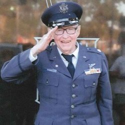
| Description | : | Kathryn "Katie" (Botos) Randall was born March 16, 1923, to Paul and Rosalia (Emrie) Botos in Missouri Valley, Iowa. Katie attended school in Missouri Valley and she graduated from Missouri Valley High School in 1941. She then attended Dana College and received her teaching degree. Katie taught in the country school in Old Town Missouri Valley and Honey Creek, Iowa. She then taught in Missouri Valley Elementary School for 39 years. On March 9, 1984, Rev. James Campbell married Katie and Richard Randall at St. Paul's Lutheran Church in Missouri Valley. The couple lived in Dunlap. Katie was a member of... Read More |
frequently asked questions (FAQ):
-
Where is Kathryn “Katie” Botos Randall's memorial?
Kathryn “Katie” Botos Randall's memorial is located at: Rose Hill Memorial Gardens, Missouri Valley, Harrison County, USA.
-
When did Kathryn “Katie” Botos Randall death?
Kathryn “Katie” Botos Randall death on 27 Sep 2014 in Baltimore City, Maryland, USA
-
Where are the coordinates of the Kathryn “Katie” Botos Randall's memorial?
Latitude: 41.5656000
Longitude: -95.8897000
Family Members:
Parent

Spouse
Siblings
Flowers:


Nearby Cemetories:
1. Rose Hill Memorial Gardens
Missouri Valley, Harrison County, USA
Coordinate: 41.5656000, -95.8897000
2. Mount Carmel Cemetery
Missouri Valley, Harrison County, USA
Coordinate: 41.5675011, -95.8897018
3. Champan Frazier Cemetery
Harrison County, USA
Coordinate: 41.5773500, -95.8933500
4. Hurleys Evergreen Cemetery
Harrison County, USA
Coordinate: 41.5700989, -95.8618698
5. Frazier Cemetery
Missouri Valley, Harrison County, USA
Coordinate: 41.5932999, -95.8375015
6. Oak Grove Cemetery
Missouri Valley, Harrison County, USA
Coordinate: 41.5167007, -95.8649979
7. Calhoun Cemetery
Calhoun, Harrison County, USA
Coordinate: 41.6391983, -95.8938980
8. Branson Cemetery
Loveland, Pottawattamie County, USA
Coordinate: 41.4846992, -95.8606033
9. Linnwood Cemetery
Harrison County, USA
Coordinate: 41.5589200, -95.7502100
10. Crook Cemetery
Honey Creek, Pottawattamie County, USA
Coordinate: 41.4581330, -95.8737000
11. Saint Bridgets Cemetery
Honey Creek, Pottawattamie County, USA
Coordinate: 41.4664001, -95.8289032
12. Logan Cemetery
Logan, Harrison County, USA
Coordinate: 41.6487579, -95.7843170
13. Harris Grove Cemetery
Beebeetown, Harrison County, USA
Coordinate: 41.5782928, -95.7262192
14. Magnolia Cemetery
Magnolia, Harrison County, USA
Coordinate: 41.6903000, -95.8799973
15. Allen Cemetery
Pottawattamie County, USA
Coordinate: 41.4427986, -95.8550034
16. Saint Bridgets Cemetery
Magnolia, Harrison County, USA
Coordinate: 41.6915660, -95.8812480
17. Grange Cemetery
Honey Creek, Pottawattamie County, USA
Coordinate: 41.4446678, -95.8034668
18. Hauger-Rumbaugh Cemetery
Modale, Harrison County, USA
Coordinate: 41.6388797, -96.0502906
19. Silver Hill Cemetery
Harrison County, USA
Coordinate: 41.6897011, -95.7919006
20. Reels Cemetery
Crescent, Pottawattamie County, USA
Coordinate: 41.4234100, -95.8321700
21. Yutesler Cemetery
Harrison County, USA
Coordinate: 41.6684000, -96.0373000
22. Fort Calhoun Cemetery
Fort Calhoun, Washington County, USA
Coordinate: 41.4581375, -96.0352020
23. Bethel Cemetery
Logan, Harrison County, USA
Coordinate: 41.6239014, -95.6999969
24. William C McIntosh Cemetery
Crescent, Pottawattamie County, USA
Coordinate: 41.4088745, -95.8477097