

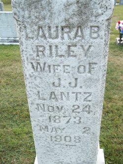
Laura Belle Riley Tucker Lantz
| Birth | : | 24 Nov 1873 Garrett County, Maryland, USA |
| Death | : | 2 May 1908 Gormania, Grant County, West Virginia, USA |
| Burial | : | Harwood Park Crematorium, Stevenage, Stevenage Borough, England |
| Coordinate | : | 51.8717680, -0.1698410 |
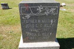
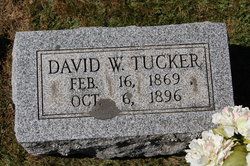
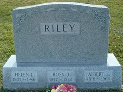
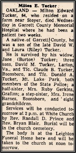
| Description | : | Listed as buried in White Church Cemetery, Page 277, Maryland's Garrett County Graves, Compiled by Youghiogheny Glades Chapter, National Society of the Daughters of the American Revolution; Oakland, Maryland; 1987. Buried w/o J.J. LAURA BELLE RILEY LANTZ 1873-1908 Daughter of John George Chirstopher Riley (1831-1907) and Eliza Ellen Biggs (1841-1907) BIRTH: 24 Nov 1873 Ryans Glades, Garrett County, Maryland DEATH: 2 May 1908 Stoyer (Near Gormania), Grant County, West Virginia BURIAL: 4 May 1908 White Church Cemetery Kearney, Garrett County, Marylnd Married (1) David W. Tucker (1869-1896) in 1893.... Read More |
frequently asked questions (FAQ):
-
Where is Laura Belle Riley Tucker Lantz's memorial?
Laura Belle Riley Tucker Lantz's memorial is located at: Harwood Park Crematorium, Stevenage, Stevenage Borough, England.
-
When did Laura Belle Riley Tucker Lantz death?
Laura Belle Riley Tucker Lantz death on 2 May 1908 in Gormania, Grant County, West Virginia, USA
-
Where are the coordinates of the Laura Belle Riley Tucker Lantz's memorial?
Latitude: 51.8717680
Longitude: -0.1698410
Family Members:
Parent

Spouse
Siblings

Children
Flowers:


Nearby Cemetories:
1. St Martin
Knebworth, North Hertfordshire District, England
Coordinate: 51.8654900, -0.1820500
2. All Saints Churchyard
Datchworth, East Hertfordshire District, England
Coordinate: 51.8575577, -0.1609916
3. Knebworth Cemetery
Knebworth, North Hertfordshire District, England
Coordinate: 51.8595280, -0.1867730
4. St. Mary's Churchyard
Aston, East Hertfordshire District, England
Coordinate: 51.8875600, -0.1536200
5. St. Mary's Churchyard
Knebworth, North Hertfordshire District, England
Coordinate: 51.8723580, -0.2160890
6. St Peter Churchyard
Benington, East Hertfordshire District, England
Coordinate: 51.8956030, -0.1167310
7. Ss Mary and Andrew Churchyard
Watton-at-Stone, East Hertfordshire District, England
Coordinate: 51.8533290, -0.1102500
8. High Street Methodist Church
Stevenage, Stevenage Borough, England
Coordinate: 51.9080740, -0.2061550
9. Almond Lane Cemetery
Stevenage, Stevenage Borough, England
Coordinate: 51.9161780, -0.1954710
10. St. Mary's Churchyard
Welwyn, Welwyn Hatfield District, England
Coordinate: 51.8311660, -0.2151400
11. Welwyn Cemetery
Welwyn, Welwyn Hatfield District, England
Coordinate: 51.8331340, -0.2199520
12. St Nicholas Churchyard
Stevenage, Stevenage Borough, England
Coordinate: 51.9201590, -0.1974750
13. Weston Road Cemetery
Stevenage, Stevenage Borough, England
Coordinate: 51.9217860, -0.1935160
14. St Andrew Church
Bramfield, East Hertfordshire District, England
Coordinate: 51.8241000, -0.1266000
15. St John the Evangelist Churchyard
Digswell, Welwyn Hatfield District, England
Coordinate: 51.8186190, -0.2051940
16. St Mary the Virgin Churchyard
Stapleford, East Hertfordshire District, England
Coordinate: 51.8349710, -0.0973140
17. St. Mary the Virgin Churchyard
Walkern, East Hertfordshire District, England
Coordinate: 51.9226300, -0.1211300
18. All Saints Churchyard
St Pauls Walden, North Hertfordshire District, England
Coordinate: 51.8865400, -0.2689200
19. St Peter Churchyard
Ayot St Peter, Welwyn Hatfield District, England
Coordinate: 51.8201700, -0.2331800
20. Minsden Chapel
Hitchin, North Hertfordshire District, England
Coordinate: 51.9069200, -0.2595700
21. All Saints Churchyard
Little Munden, East Hertfordshire District, England
Coordinate: 51.8795770, -0.0625920
22. Ayot St Lawrence Old Churchyard
Ayot St Lawrence, Welwyn Hatfield District, England
Coordinate: 51.8377038, -0.2678795
23. St Lawrence Churchyard
Ardeley, East Hertfordshire District, England
Coordinate: 51.9274000, -0.0989000
24. St Lawrence Churchyard
Ayot St Lawrence, Welwyn Hatfield District, England
Coordinate: 51.8379490, -0.2717340