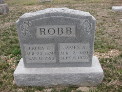
Laura E. Ford Robb
| Birth | : | 23 Apr 1874 |
| Death | : | 11 Mar 1953 |
| Burial | : | Lichfield Cathedral, Lichfield, Lichfield District, England |
| Coordinate | : | 52.6855650, -1.8304500 |
| Plot | : | North Section, Block 8, Row 2, Lot 2, Plot 3 |
frequently asked questions (FAQ):
-
Where is Laura E. Ford Robb's memorial?
Laura E. Ford Robb's memorial is located at: Lichfield Cathedral, Lichfield, Lichfield District, England.
-
When did Laura E. Ford Robb death?
Laura E. Ford Robb death on 11 Mar 1953 in
-
Where are the coordinates of the Laura E. Ford Robb's memorial?
Latitude: 52.6855650
Longitude: -1.8304500
Family Members:
Parent
Spouse
Siblings
Children
Flowers:
Nearby Cemetories:
1. Lichfield Cathedral
Lichfield, Lichfield District, England
Coordinate: 52.6855650, -1.8304500
2. Grey Friars Churchyard
Lichfield, Lichfield District, England
Coordinate: 52.6829030, -1.8282720
3. St Chad Churchyard
Lichfield, Lichfield District, England
Coordinate: 52.6895810, -1.8209640
4. Christ Church Churchyard
Lichfield, Lichfield District, England
Coordinate: 52.6812150, -1.8405800
5. St Michael's Churchyard
Lichfield, Lichfield District, England
Coordinate: 52.6834590, -1.8182370
6. Stychbrook Cemetery
Lichfield District, England
Coordinate: 52.6998096, -1.8347392
7. St. John's Churchyard
Wall, Lichfield District, England
Coordinate: 52.6575100, -1.8553200
8. St Matthew's Hospital Burial Ground
Burntwood, Lichfield District, England
Coordinate: 52.6804500, -1.8937800
9. St. Giles' Churchyard
Whittington, Lichfield District, England
Coordinate: 52.6723850, -1.7677160
10. Christchurch Cemetery
Burntwood, Lichfield District, England
Coordinate: 52.6787639, -1.8969201
11. St. James the Great Churchyard
Longdon, Lichfield District, England
Coordinate: 52.7250710, -1.8800360
12. Saint Stephen Churchyard
Fradley, Lichfield District, England
Coordinate: 52.7183456, -1.7686180
13. St Mary the Virgin New Churchyard
Weeford, Lichfield District, England
Coordinate: 52.6330806, -1.7923083
14. St. Mary the Virgin Churchyard
Weeford, Lichfield District, England
Coordinate: 52.6322300, -1.7923200
15. Christ Church Gentleshaw
Rugeley, Cannock Chase District, England
Coordinate: 52.7050151, -1.9264458
16. Chase and District Memorial Park
Burntwood, Lichfield District, England
Coordinate: 52.6817140, -1.9339150
17. St Peter's Churchyard
Elford, Lichfield District, England
Coordinate: 52.6928330, -1.7274120
18. St John's Church Cemetery
Burntwood, Lichfield District, England
Coordinate: 52.6901000, -1.9349300
19. St. Anne Churchyard Chasetown
Burntwood, Lichfield District, England
Coordinate: 52.6693850, -1.9381720
20. All Saints Churchyard
Alrewas, Lichfield District, England
Coordinate: 52.7347941, -1.7530332
21. St Chad's
Tamworth Borough, England
Coordinate: 52.6433000, -1.7418000
22. St John the Baptist Churchyard
Armitage with Handsacre, Lichfield District, England
Coordinate: 52.7458638, -1.8851159
23. St Peter's Churchyard
Stonnall, Lichfield District, England
Coordinate: 52.6266750, -1.8923110
24. Hopwas Cemetery
Tamworth, Tamworth Borough, England
Coordinate: 52.6417200, -1.7362600

