
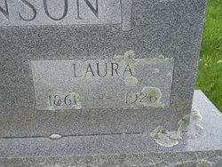

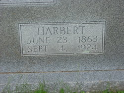
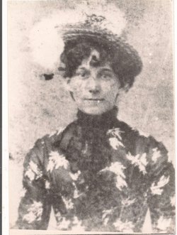
Laura Farmer Robinson
| Birth | : | 18 Sep 1861 Carroll County, Virginia, USA |
| Death | : | 13 Feb 1926 Carroll County, Virginia, USA |
| Burial | : | Irchester Saint Katherine Churchyard, Irchester, Wellingborough Borough, England |
| Coordinate | : | 52.2843900, -0.6446900 |
frequently asked questions (FAQ):
-
Where is Laura Farmer Robinson's memorial?
Laura Farmer Robinson's memorial is located at: Irchester Saint Katherine Churchyard, Irchester, Wellingborough Borough, England.
-
When did Laura Farmer Robinson death?
Laura Farmer Robinson death on 13 Feb 1926 in Carroll County, Virginia, USA
-
Where are the coordinates of the Laura Farmer Robinson's memorial?
Latitude: 52.2843900
Longitude: -0.6446900
Family Members:
Parent
Spouse
Siblings

Children
Flowers:


Nearby Cemetories:
1. Irchester Saint Katherine Churchyard
Irchester, Wellingborough Borough, England
Coordinate: 52.2843900, -0.6446900
2. Irchester Cemetery
Irchester, Wellingborough Borough, England
Coordinate: 52.2848000, -0.6456000
3. St. Michael's Church
Farndish, Bedford Borough, England
Coordinate: 52.2638108, -0.6416839
4. St Mary Churchyard
Rushden, East Northamptonshire Borough, England
Coordinate: 52.2885570, -0.5973860
5. London Road Cemetery
Wellingborough, Wellingborough Borough, England
Coordinate: 52.2986000, -0.6878000
6. St Lawrence Churchyard
Wymington, Bedford Borough, England
Coordinate: 52.2694310, -0.6017230
7. Nene Valley Crematorium
Wellingborough, Wellingborough Borough, England
Coordinate: 52.2827104, -0.6945270
8. All Saints Churchyard
Wellingborough, Wellingborough Borough, England
Coordinate: 52.3010890, -0.6879730
9. Wollaston
Wollaston, Wellingborough Borough, England
Coordinate: 52.2581088, -0.6726313
10. Doddington Road Cemetery
Wellingborough, Wellingborough Borough, England
Coordinate: 52.2942380, -0.6956600
11. St Mary the Virgin Churchyard
Podington, Bedford Borough, England
Coordinate: 52.2539100, -0.6220900
12. New Irthlingborough Cemetery
Irthlingborough, East Northamptonshire Borough, England
Coordinate: 52.3178531, -0.6294229
13. All Hallows Churchyard
Wellingborough Borough, England
Coordinate: 52.3024740, -0.6937430
14. Newton Road Cemetery
Rushden, East Northamptonshire Borough, England
Coordinate: 52.2882140, -0.5859750
15. Higham Ferrers Cemetery
Higham Ferrers, East Northamptonshire Borough, England
Coordinate: 52.3084850, -0.5945270
16. St. Mary the Virgin Churchyard
Higham Ferrers, East Northamptonshire Borough, England
Coordinate: 52.3065500, -0.5915240
17. St. Nicholas' Churchyard
Great Doddington, Wellingborough Borough, England
Coordinate: 52.2747326, -0.7097420
18. St Rumwold's Churchyard
Strixton, Wellingborough Borough, England
Coordinate: 52.2456740, -0.6777530
19. St Peter's Churchyard
Irthlingborough, East Northamptonshire Borough, England
Coordinate: 52.3251642, -0.6101925
20. Saint Mary Churchyard
Wilby, Wellingborough Borough, England
Coordinate: 52.2868890, -0.7309180
21. Saint Mary the Virgin Churchyard Extension
Finedon, Wellingborough Borough, England
Coordinate: 52.3385489, -0.6613748
22. Finedon
Finedon, Wellingborough Borough, England
Coordinate: 52.3407999, -0.6648562
23. All Saints Churchyard
Great Harrowden, Wellingborough Borough, England
Coordinate: 52.3286800, -0.7096600
24. Earls Barton Cemetery
Earls Barton, Wellingborough Borough, England
Coordinate: 52.2739600, -0.7468900