
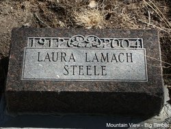
Laura Lamach Steele
| Birth | : | 29 Mar 1912 Ogema, Becker County, Minnesota, USA |
| Death | : | 24 Jun 2004 Seattle, King County, Washington, USA |
| Burial | : | Lugnet kyrkogård, Lycksele, Lycksele kommun, Sweden |
| Coordinate | : | 64.6072000, 18.6502000 |
| Plot | : | Section 5 Blk 37 Lot 1. Grave 6 |
| Description | : | From Ravalli Republic (Hamilton, MT) 7/7/2004: Laura Lamach Steele, 92, of Hamilton, died June 24, 2004, at the University of Washington Medical Center in Seattle. Born March 29, 1912, in Ogema, Minn., to John and Mary Lamach, she was a middle child in a family of 15. She was preceded in death by all of her brothers and sisters. The family moved to Montana in 1913, and lived in several locations in central Montana. She graduated from Sweet Grass High School and attended the two-year normal school in Billings. In later years, she completed post-graduate work at the University of Montana in Missoula.... Read More |
frequently asked questions (FAQ):
-
Where is Laura Lamach Steele's memorial?
Laura Lamach Steele's memorial is located at: Lugnet kyrkogård, Lycksele, Lycksele kommun, Sweden.
-
When did Laura Lamach Steele death?
Laura Lamach Steele death on 24 Jun 2004 in Seattle, King County, Washington, USA
-
Where are the coordinates of the Laura Lamach Steele's memorial?
Latitude: 64.6072000
Longitude: 18.6502000
Family Members:
Parent
Spouse
Siblings

Children
Flowers:


Nearby Cemetories:
1. Lugnet kyrkogård
Lycksele, Lycksele kommun, Sweden
Coordinate: 64.6072000, 18.6502000
2. Lycksele Gamla Kyrkogården
Lycksele, Lycksele kommun, Sweden
Coordinate: 64.5988370, 18.6718580
3. Berglunda Kyrkogård
Lycksele, Lycksele kommun, Sweden
Coordinate: 64.5634000, 18.6954000
4. Björksele kyrkogård
Bjorksele, Lycksele kommun, Sweden
Coordinate: 64.9884300, 18.5157800
5. Näsets kyrkogård
Norsjö, Norsjö kommun, Sweden
Coordinate: 64.8945800, 19.4582541
6. Åskilje Cemetery
Askilje, Storumans kommun, Sweden
Coordinate: 64.9083320, 17.8625680
7. Norsjö kyrkogård
Norsjö, Norsjö kommun, Sweden
Coordinate: 64.9147237, 19.4762989
8. Granö kyrkogård
Granon, Vindelns kommun, Sweden
Coordinate: 64.2214400, 19.3540000
9. Kalvträsks Kyrkogård
Kalvtrask, Skellefteå kommun, Sweden
Coordinate: 64.6727660, 19.7887160
10. Malå Gamla Kyrkogård
Malå, Malå kommun, Sweden
Coordinate: 65.1845440, 18.7416800
11. Malå Skogskyrkogård
Malå, Malå kommun, Sweden
Coordinate: 65.1892980, 18.7387920
12. Latikberg kyrkogård
Latikberg, Vilhelmina kommun, Sweden
Coordinate: 64.6440076, 17.0792300
13. Adak Kyrkogård
Adak, Malå kommun, Sweden
Coordinate: 65.3521560, 18.5932230
14. Gargnäs Kyrkogård
Gargnas, Sorsele kommun, Sweden
Coordinate: 65.3120659, 17.9621481
15. Glommersträsk Kyrkogård
Glommerstrask, Arvidsjaurs kommun, Sweden
Coordinate: 65.2812400, 19.6099900
16. Bygdsiljums Kyrkogård
Bygdsiljum, Skellefteå kommun, Sweden
Coordinate: 64.3480080, 20.5066770
17. Vilhelmina Church Cemetery
Vilhelmina, Vilhelmina kommun, Sweden
Coordinate: 64.6300714, 16.6437804
18. Vara Cemetery
Vara, Vara kommun, Sweden
Coordinate: 64.7456327, 20.8466761
19. Lund Cemetery
Lund, Skellefteå kommun, Sweden
Coordinate: 64.7491080, 20.9055672
20. Skellefteå Västra kyrkogård
Skellefteå, Skellefteå kommun, Sweden
Coordinate: 64.7519900, 20.9186000
21. Gråträsk Kyrkogård
Gratrask, Piteå kommun, Sweden
Coordinate: 65.4861640, 19.7961550
22. Arvidsjaurs Kyrkogård
Arvidsjaur, Arvidsjaurs kommun, Sweden
Coordinate: 65.5955674, 19.1669004
23. Alhems Kyrkogård (skogskyrkogården)
Skellefteå, Skellefteå kommun, Sweden
Coordinate: 64.7557797, 20.9985884
24. Slagnäs Kyrkogård
Slagnas, Arjeplogs kommun, Sweden
Coordinate: 65.6028381, 18.1647942