
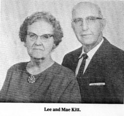
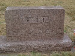
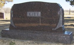
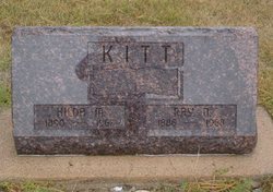
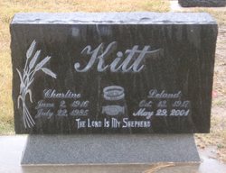
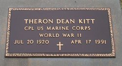
Lee Earl Kitt
| Birth | : | 26 Nov 1889 |
| Death | : | Aug 1968 |
| Burial | : | St John the Baptist Churchyard, Burscough, West Lancashire District, England |
| Coordinate | : | 53.6042760, -2.8401390 |
frequently asked questions (FAQ):
-
Where is Lee Earl Kitt's memorial?
Lee Earl Kitt's memorial is located at: St John the Baptist Churchyard, Burscough, West Lancashire District, England.
-
When did Lee Earl Kitt death?
Lee Earl Kitt death on Aug 1968 in
-
Where are the coordinates of the Lee Earl Kitt's memorial?
Latitude: 53.6042760
Longitude: -2.8401390
Family Members:
Parent

Spouse

Siblings
Children
Flowers:


Nearby Cemetories:
1. St John the Baptist Churchyard
Burscough, West Lancashire District, England
Coordinate: 53.6042760, -2.8401390
2. St John The Evangelist Roman Catholic Church
Burscough, West Lancashire District, England
Coordinate: 53.5902152, -2.8424163
3. Burscough Priory
Burscough, West Lancashire District, England
Coordinate: 53.5830270, -2.8565030
4. Lathom Park Chapel
Lathom, West Lancashire District, England
Coordinate: 53.5782510, -2.8216720
5. West Lancashire Cemetery and Crematorium
Burscough, West Lancashire District, England
Coordinate: 53.5875500, -2.8820300
6. St. Mary the Virgin Churchyard
Rufford, West Lancashire District, England
Coordinate: 53.6349960, -2.8126410
7. Christchurch Churchyard
Newburgh, West Lancashire District, England
Coordinate: 53.5876845, -2.7842440
8. St. Peter's Churchyard
Mawdesley, Chorley Borough, England
Coordinate: 53.6237600, -2.7734100
9. St Peter and St Paul Churchyard
Ormskirk, West Lancashire District, England
Coordinate: 53.5692640, -2.8877690
10. St. James Churchyard
Westhead, West Lancashire District, England
Coordinate: 53.5582324, -2.8527492
11. Our Lady and All Saints Roman Catholic
Parbold, West Lancashire District, England
Coordinate: 53.5911900, -2.7644350
12. St. Elizabeth's Churchyard
Scarisbrick, West Lancashire District, England
Coordinate: 53.6124460, -2.9206340
13. Saint Anne's Roman Catholic Church Cemetery
Ormskirk, West Lancashire District, England
Coordinate: 53.5626520, -2.8935560
14. Christ Church Churchyard
Parbold, West Lancashire District, England
Coordinate: 53.5908500, -2.7531900
15. St. Michael's Churchyard
Dalton, West Lancashire District, England
Coordinate: 53.5670360, -2.7640390
16. Christ Churchyard
Aughton, West Lancashire District, England
Coordinate: 53.5583510, -2.9046990
17. St. Mark Churchyard
Scarisbrick, West Lancashire District, England
Coordinate: 53.6134600, -2.9403800
18. St. Peter and St. Paul Churchyard
Mawdesley, Chorley Borough, England
Coordinate: 53.6266580, -2.7451420
19. St. Paul's Churchyard
Skelmersdale, West Lancashire District, England
Coordinate: 53.5502050, -2.7929450
20. Skelmersdale Cemetery
Skelmersdale, West Lancashire District, England
Coordinate: 53.5446820, -2.8131570
21. St. Richard's Roman Catholic Cemetery
Skelmersdale, West Lancashire District, England
Coordinate: 53.5442920, -2.8143760
22. Croston Cemetery
Croston, Chorley Borough, England
Coordinate: 53.6586700, -2.7733100
23. St. Cuthbert's Churchyard
Halsall, West Lancashire District, England
Coordinate: 53.5852140, -2.9529650
24. St. Mary's Churchyard
Tarleton, West Lancashire District, England
Coordinate: 53.6746100, -2.8239200