
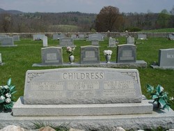
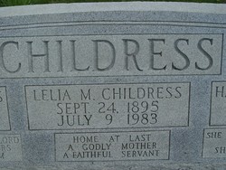
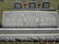
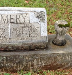
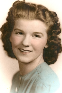
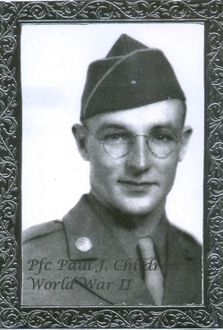
Lelia Mae “Mamie” Montgomery Childress
| Birth | : | 24 Sep 1895 |
| Death | : | 9 Jul 1983 |
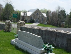
| Burial | : | Holy Trinity Churchyard, Hoghton, Chorley Borough, England |
| Coordinate | : | 53.7279300, -2.5848550 |
| Inscription | : | Home At Last, A Godly Mother, A Faithful Servant |
frequently asked questions (FAQ):
-
Where is Lelia Mae “Mamie” Montgomery Childress's memorial?
Lelia Mae “Mamie” Montgomery Childress's memorial is located at: Holy Trinity Churchyard, Hoghton, Chorley Borough, England.
-
When did Lelia Mae “Mamie” Montgomery Childress death?
Lelia Mae “Mamie” Montgomery Childress death on 9 Jul 1983 in
-
Where are the coordinates of the Lelia Mae “Mamie” Montgomery Childress's memorial?
Latitude: 53.7279300
Longitude: -2.5848550
Family Members:
Parent

Spouse
Siblings

Children


Nearby Cemetories:
1. Holy Trinity Churchyard
Hoghton, Chorley Borough, England
Coordinate: 53.7279300, -2.5848550
2. St. Josephs Roman Catholic Churchyard
Brindle, Chorley Borough, England
Coordinate: 53.7350780, -2.5880640
3. St James's Churchyard
Brindle, Chorley Borough, England
Coordinate: 53.7133333, -2.6086111
4. Pleasington Priory
Pleasington, Blackburn with Darwen Unitary Authority, England
Coordinate: 53.7348590, -2.5433060
5. Pleasington Cemetery and Crematorium
Blackburn, Blackburn with Darwen Unitary Authority, England
Coordinate: 53.7388880, -2.5368710
6. St Paul's Churchyard
Withnell, Chorley Borough, England
Coordinate: 53.6970740, -2.5592150
7. All Saints Churchyard
Walton-le-Dale, South Ribble Borough, England
Coordinate: 53.7407250, -2.6408280
8. Our Lady and St Patrick's Church
Walton-le-Dale, South Ribble Borough, England
Coordinate: 53.7407250, -2.6408280
9. St. Bedes Churchyard
Clayton-le-Woods, Chorley Borough, England
Coordinate: 53.7079260, -2.6390320
10. St. Mary's and St. John RC Churchyard, Southworth
Samlesbury, South Ribble Borough, England
Coordinate: 53.7676690, -2.6183400
11. St. Saviour's Churchyard
Bamber Bridge, South Ribble Borough, England
Coordinate: 53.7197301, -2.6598985
12. St Stephen Churchyard
Tockholes, Blackburn with Darwen Unitary Authority, England
Coordinate: 53.7058350, -2.5169320
13. St. Leonard the Less Churchyard
Samlesbury, South Ribble Borough, England
Coordinate: 53.7680000, -2.6237000
14. St. Chad's South Hill Churchyard
Wheelton, Chorley Borough, England
Coordinate: 53.6826040, -2.6125010
15. St Mary's Churchyard Brownedge
Bamber Bridge, South Ribble Borough, England
Coordinate: 53.7305472, -2.6669416
16. New Row Methodist Church
Blackburn with Darwen Unitary Authority, England
Coordinate: 53.7208950, -2.5023720
17. St Barnabas Churchyard
Heapey, Chorley Borough, England
Coordinate: 53.6792520, -2.6043310
18. St John the Evangelist Churchyard
Whittle-le-Woods, Chorley Borough, England
Coordinate: 53.6883280, -2.6400320
19. St Leonard Churchyard
Walton-le-Dale, South Ribble Borough, England
Coordinate: 53.7476530, -2.6666950
20. St. Mary's Churchyard
Mellor, Ribble Valley Borough, England
Coordinate: 53.7728600, -2.5312400
21. Mellor Methodist Churchyard
Blackburn, Blackburn with Darwen Unitary Authority, England
Coordinate: 53.7742950, -2.5255060
22. St Leonard Churchyard
Balderstone, Ribble Valley Borough, England
Coordinate: 53.7860070, -2.5609380
23. St Paul's
Blackburn, Blackburn with Darwen Unitary Authority, England
Coordinate: 53.7491222, -2.4891266
24. St. Peter's Churchyard
Blackburn, Blackburn with Darwen Unitary Authority, England
Coordinate: 53.7448110, -2.4865070