
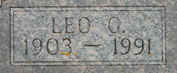
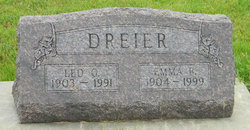
Leo Gustaf William Dreier
| Birth | : | 26 Mar 1903 |
| Death | : | 6 May 1991 |
| Burial | : | Wilbury Hills Cemetery, Letchworth, North Hertfordshire District, England |
| Coordinate | : | 51.9862210, -0.2474770 |
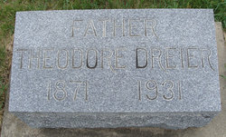
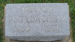
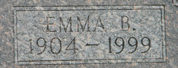
| Description | : | SOURCE: Monona, Iowa MONONA BILLBOARD, May 22, 1991 Contributor: Connie Ellis (Not related) Leo Gustaf William Dreier, son of Theodore and Mathilda (Hahn) Dreier, was born March 26, 1903 in Winneshiek County, near Frankville, Iowa. He was baptized and confirmed in Frankville at the Presbyterian Church. He attended rural school near his home. On June 29, 1926 he was united in marriage to Emma Bertha Martens in St. Paul Lutheran Church at Postville, Iowa by the Rev. Fink. The had one son. They farmed in the Frankville area, and then on another farm north of Postville, Iowa. In 1957 they... Read More |
frequently asked questions (FAQ):
-
Where is Leo Gustaf William Dreier's memorial?
Leo Gustaf William Dreier's memorial is located at: Wilbury Hills Cemetery, Letchworth, North Hertfordshire District, England.
-
When did Leo Gustaf William Dreier death?
Leo Gustaf William Dreier death on 6 May 1991 in
-
Where are the coordinates of the Leo Gustaf William Dreier's memorial?
Latitude: 51.9862210
Longitude: -0.2474770
Family Members:
Parent
Spouse
Siblings
Children

Flowers:


Nearby Cemetories:
1. Wilbury Hills Cemetery
Letchworth, North Hertfordshire District, England
Coordinate: 51.9862210, -0.2474770
2. Icknield Way Cemetery
Letchworth, North Hertfordshire District, England
Coordinate: 51.9787300, -0.2506100
3. Fairfield Hospital Cemetery
Stotfold, Central Bedfordshire Unitary Authority, England
Coordinate: 52.0040420, -0.2495440
4. St Nicholas Churchyard
Letchworth, North Hertfordshire District, England
Coordinate: 51.9948300, -0.2078900
5. North Hertfordshire Memorial Park and Crematorium
Holwell, North Hertfordshire District, England
Coordinate: 51.9847244, -0.2967870
6. All Saints Churchyard
Willian, North Hertfordshire District, England
Coordinate: 51.9609140, -0.2191160
7. Baldock Cemetery
Baldock, North Hertfordshire District, England
Coordinate: 51.9901010, -0.1960690
8. St Mary the Virgin Churchyard
Stotfold, Central Bedfordshire Unitary Authority, England
Coordinate: 52.0150980, -0.2232980
9. St Mary Churchyard
Baldock, North Hertfordshire District, England
Coordinate: 51.9897380, -0.1898930
10. Stotfold Cemetery
Stotfold, Central Bedfordshire Unitary Authority, England
Coordinate: 52.0186450, -0.2189540
11. St. Peter's Churchyard
Arlesey, Central Bedfordshire Unitary Authority, England
Coordinate: 52.0234710, -0.2643140
12. Hitchin Cemetery
Hitchin, North Hertfordshire District, England
Coordinate: 51.9429090, -0.2732690
13. All Saints Churchyard
Radwell, North Hertfordshire District, England
Coordinate: 51.9747300, -0.1668550
14. St. Vincent Churchyard
Newnham, North Hertfordshire District, England
Coordinate: 52.0229100, -0.1897200
15. All Saints Churchyard
Upper Stondon, Central Bedfordshire Unitary Authority, England
Coordinate: 52.0065450, -0.3258350
16. St Mary Magdalene's Church
Caldecote, North Hertfordshire District, England
Coordinate: 52.0304700, -0.1989020
17. St Mary Churchyard
Henlow, Central Bedfordshire Unitary Authority, England
Coordinate: 52.0348580, -0.2834610
18. Saint Mary the Virgin Churchyard
Pirton, North Hertfordshire District, England
Coordinate: 51.9722000, -0.3316600
19. St Ippolyts Church
St Ippolyts, North Hertfordshire District, England
Coordinate: 51.9298460, -0.2591680
20. Clifton Friends Burial Ground
Clifton, Central Bedfordshire Unitary Authority, England
Coordinate: 52.0378800, -0.3033100
21. All Saints Churchyard
Clifton, Central Bedfordshire Unitary Authority, England
Coordinate: 52.0393990, -0.3015550
22. Clifton Baptist Chapelyard
Clifton, Central Bedfordshire Unitary Authority, England
Coordinate: 52.0398940, -0.3025180
23. All Saints New Churchyard
Clifton, Central Bedfordshire Unitary Authority, England
Coordinate: 52.0403500, -0.3018700
24. St Mary the Virgin Churchyard
Meppershall, Central Bedfordshire Unitary Authority, England
Coordinate: 52.0102000, -0.3483000