
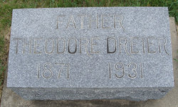

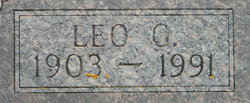
Theodore Dreier
| Birth | : | 16 Sep 1871 Germany |
| Death | : | 15 Sep 1931 Winneshiek County, Iowa, USA |
| Burial | : | Wilbury Hills Cemetery, Letchworth, North Hertfordshire District, England |
| Coordinate | : | 51.9862210, -0.2474770 |
| Description | : | He was born in Marien, Mechlenberg-Schwerin, Germany and came to US at age 21, with his parents who settled near Postville. He died at his farm home in Bloomfield Township from a lingering illness. |
frequently asked questions (FAQ):
-
Where is Theodore Dreier's memorial?
Theodore Dreier's memorial is located at: Wilbury Hills Cemetery, Letchworth, North Hertfordshire District, England.
-
When did Theodore Dreier death?
Theodore Dreier death on 15 Sep 1931 in Winneshiek County, Iowa, USA
-
Where are the coordinates of the Theodore Dreier's memorial?
Latitude: 51.9862210
Longitude: -0.2474770
Family Members:
Parent
Spouse
Siblings
Children
Flowers:


Nearby Cemetories:
1. Wilbury Hills Cemetery
Letchworth, North Hertfordshire District, England
Coordinate: 51.9862210, -0.2474770
2. Icknield Way Cemetery
Letchworth, North Hertfordshire District, England
Coordinate: 51.9787300, -0.2506100
3. Fairfield Hospital Cemetery
Stotfold, Central Bedfordshire Unitary Authority, England
Coordinate: 52.0040420, -0.2495440
4. St Nicholas Churchyard
Letchworth, North Hertfordshire District, England
Coordinate: 51.9948300, -0.2078900
5. North Hertfordshire Memorial Park and Crematorium
Holwell, North Hertfordshire District, England
Coordinate: 51.9847244, -0.2967870
6. All Saints Churchyard
Willian, North Hertfordshire District, England
Coordinate: 51.9609140, -0.2191160
7. Baldock Cemetery
Baldock, North Hertfordshire District, England
Coordinate: 51.9901010, -0.1960690
8. St Mary the Virgin Churchyard
Stotfold, Central Bedfordshire Unitary Authority, England
Coordinate: 52.0150980, -0.2232980
9. St Mary Churchyard
Baldock, North Hertfordshire District, England
Coordinate: 51.9897380, -0.1898930
10. Stotfold Cemetery
Stotfold, Central Bedfordshire Unitary Authority, England
Coordinate: 52.0186450, -0.2189540
11. St. Peter's Churchyard
Arlesey, Central Bedfordshire Unitary Authority, England
Coordinate: 52.0234710, -0.2643140
12. Hitchin Cemetery
Hitchin, North Hertfordshire District, England
Coordinate: 51.9429090, -0.2732690
13. All Saints Churchyard
Radwell, North Hertfordshire District, England
Coordinate: 51.9747300, -0.1668550
14. St. Vincent Churchyard
Newnham, North Hertfordshire District, England
Coordinate: 52.0229100, -0.1897200
15. All Saints Churchyard
Upper Stondon, Central Bedfordshire Unitary Authority, England
Coordinate: 52.0065450, -0.3258350
16. St Mary Magdalene's Church
Caldecote, North Hertfordshire District, England
Coordinate: 52.0304700, -0.1989020
17. St Mary Churchyard
Henlow, Central Bedfordshire Unitary Authority, England
Coordinate: 52.0348580, -0.2834610
18. Saint Mary the Virgin Churchyard
Pirton, North Hertfordshire District, England
Coordinate: 51.9722000, -0.3316600
19. St Ippolyts Church
St Ippolyts, North Hertfordshire District, England
Coordinate: 51.9298460, -0.2591680
20. Clifton Friends Burial Ground
Clifton, Central Bedfordshire Unitary Authority, England
Coordinate: 52.0378800, -0.3033100
21. All Saints Churchyard
Clifton, Central Bedfordshire Unitary Authority, England
Coordinate: 52.0393990, -0.3015550
22. Clifton Baptist Chapelyard
Clifton, Central Bedfordshire Unitary Authority, England
Coordinate: 52.0398940, -0.3025180
23. All Saints New Churchyard
Clifton, Central Bedfordshire Unitary Authority, England
Coordinate: 52.0403500, -0.3018700
24. St Mary the Virgin Churchyard
Meppershall, Central Bedfordshire Unitary Authority, England
Coordinate: 52.0102000, -0.3483000