
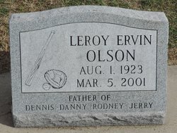
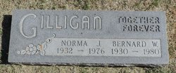
Leroy Ervin “Ding” Olson
| Birth | : | 1 Aug 1923 Oconto, Custer County, Nebraska, USA |
| Death | : | 5 Mar 2001 Broken Bow, Custer County, Nebraska, USA |
| Burial | : | St Mary the Virgin Churchyard, Lamberhurst, Tunbridge Wells Borough, England |
| Coordinate | : | 51.1040459, 0.4012690 |
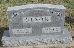
| Description | : | Son of Frank Walter & Mary E. (Whipple) Olson. Married to: 1. Bertha Mae Kruse on 1-5-1944. 2. Elaine Pettinger on 12-31-1978. |
frequently asked questions (FAQ):
-
Where is Leroy Ervin “Ding” Olson's memorial?
Leroy Ervin “Ding” Olson's memorial is located at: St Mary the Virgin Churchyard, Lamberhurst, Tunbridge Wells Borough, England.
-
When did Leroy Ervin “Ding” Olson death?
Leroy Ervin “Ding” Olson death on 5 Mar 2001 in Broken Bow, Custer County, Nebraska, USA
-
Where are the coordinates of the Leroy Ervin “Ding” Olson's memorial?
Latitude: 51.1040459
Longitude: 0.4012690
Family Members:
Parent

Siblings

Children
Flowers:


Nearby Cemetories:
1. St Mary the Virgin Churchyard
Lamberhurst, Tunbridge Wells Borough, England
Coordinate: 51.1040459, 0.4012690
2. Christ Church Churchyard
Kilndown, Tunbridge Wells Borough, England
Coordinate: 51.0907820, 0.4269340
3. St Margarets Churchyard
Horsmonden, Tunbridge Wells Borough, England
Coordinate: 51.1169060, 0.4329730
4. Bayham Old Abbey
Lamberhurst, Tunbridge Wells Borough, England
Coordinate: 51.1032690, 0.3541800
5. Goudhurst War Memorial
Goudhurst, Tunbridge Wells Borough, England
Coordinate: 51.1129960, 0.4586850
6. St. Mary the Virgin Churchyard
Goudhurst, Tunbridge Wells Borough, England
Coordinate: 51.1136160, 0.4609480
7. Goudhurst Cemetery
Goudhurst, Tunbridge Wells Borough, England
Coordinate: 51.1134210, 0.4624930
8. St. Luke's Churchyard
Matfield, Tunbridge Wells Borough, England
Coordinate: 51.1426588, 0.3626785
9. All Saints Churchyard
Brenchley, Tunbridge Wells Borough, England
Coordinate: 51.1504200, 0.4001200
10. St. Peter & St. Paul Churchyard
Wadhurst, Wealden District, England
Coordinate: 51.0626960, 0.3400690
11. St. Mary's Churchyard
Ticehurst, Rother District, England
Coordinate: 51.0454030, 0.4077110
12. Pembury Burial Ground
Pembury, Tunbridge Wells Borough, England
Coordinate: 51.1416270, 0.3229290
13. Saint Augustine's Churchyard
Flimwell, Rother District, England
Coordinate: 51.0514170, 0.4580350
14. St Peter's New Churchyard
Pembury, Tunbridge Wells Borough, England
Coordinate: 51.1506200, 0.3269600
15. Paddock Wood New Cemetery
Paddock Wood, Tunbridge Wells Borough, England
Coordinate: 51.1761499, 0.3980419
16. St. Peter's Churchyard
Stonegate, Rother District, England
Coordinate: 51.0303090, 0.3747690
17. St. Andrew's Old Churchyard
Paddock Wood, Tunbridge Wells Borough, England
Coordinate: 51.1799720, 0.3923060
18. Old Churchyard of St Peter
Pembury, Tunbridge Wells Borough, England
Coordinate: 51.1629330, 0.3241620
19. Kent and Sussex Cemetery and Crematorium
Royal Tunbridge Wells, Tunbridge Wells Borough, England
Coordinate: 51.1173720, 0.2740330
20. St. Thomas A. Becket Churchyard
Capel, Tunbridge Wells Borough, England
Coordinate: 51.1764880, 0.3414880
21. St. Alban's Churchyard
Frant, Wealden District, England
Coordinate: 51.0980580, 0.2698300
22. Tidebrook Churchyard
Wadhurst, Wealden District, England
Coordinate: 51.0467700, 0.3013730
23. St Dunstan's Churchyard
Cranbrook, Tunbridge Wells Borough, England
Coordinate: 51.0973030, 0.5363690
24. St David's Bridge Strict Baptist Chapel
Cranbrook, Tunbridge Wells Borough, England
Coordinate: 51.0953430, 0.5378980