

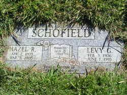
Levy Gordrey Schofield
| Birth | : | 3 Feb 1906 Pontiac, Ozark County, Missouri, USA |
| Death | : | 7 Jun 1995 Chelan, Chelan County, Washington, USA |
| Burial | : | Union Rice Cemetery, Union, Boone County, USA |
| Coordinate | : | 38.9481010, -84.6675034 |
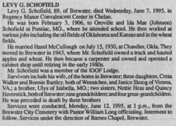
| Description | : | Levy G. Scholfield, 89, of Brewster, died Wednesday, June 7, 1995, in Regency Manor convalescent Center in Chelan. He was born February 3, 1906, to Oroville and Ida Mae (Johnson) Scholfield at Pontiac, Mo., where he attended school. He then worked at various jobs including the oil fields of Okalahoma and Kansas in the wheat fields. He married Hazel McCullough on July 15, 1930, at Chandler, Okla. They moved to Brewster in 1943, where Mr. Schofield owned a truck and hauled apples and wheat. He then became a carpenter and owned and operated a cabinet shop until retiring in the early 1980s. Survivors... Read More |
frequently asked questions (FAQ):
-
Where is Levy Gordrey Schofield's memorial?
Levy Gordrey Schofield's memorial is located at: Union Rice Cemetery, Union, Boone County, USA.
-
When did Levy Gordrey Schofield death?
Levy Gordrey Schofield death on 7 Jun 1995 in Chelan, Chelan County, Washington, USA
-
Where are the coordinates of the Levy Gordrey Schofield's memorial?
Latitude: 38.9481010
Longitude: -84.6675034
Family Members:
Parent
Spouse
Siblings
Flowers:


Nearby Cemetories:
1. Union Rice Cemetery
Union, Boone County, USA
Coordinate: 38.9481010, -84.6675034
2. Hamilton Cemetery
Union, Boone County, USA
Coordinate: 38.9547410, -84.6687910
3. Stansifer-Utz Cemetery
Union, Boone County, USA
Coordinate: 38.9419289, -84.6791534
4. Clarkson Family Cemetery
Union, Boone County, USA
Coordinate: 38.9401620, -84.6559290
5. Bethel Baptist Church Cemetery
Union, Boone County, USA
Coordinate: 38.9356040, -84.6677790
6. Carter Family Cemetery
Union, Boone County, USA
Coordinate: 38.9370090, -84.6565470
7. Cleek Cemetery (Defunct)
Union, Boone County, USA
Coordinate: 38.9341620, -84.6634140
8. Piper Family Cemetery
Florence, Boone County, USA
Coordinate: 38.9555050, -84.6514690
9. Philip Baker Cemetery (Defunct)
Union, Boone County, USA
Coordinate: 38.9338890, -84.6730560
10. Marshall Family Cemetery
Union, Boone County, USA
Coordinate: 38.9438890, -84.6455560
11. Tanner Family Cemetery
Florence, Boone County, USA
Coordinate: 38.9653710, -84.6551220
12. Stanton Aylor Cemetery (Defunct)
Florence, Boone County, USA
Coordinate: 38.9675900, -84.6718100
13. Hugh Steers Burial Site
Florence, Boone County, USA
Coordinate: 38.9340280, -84.6865210
14. Tanner-Utz Cemetery (Defunct)
Florence, Boone County, USA
Coordinate: 38.9736110, -84.6655560
15. Butts-Snow-Loar Cemetery
Union, Boone County, USA
Coordinate: 38.9328660, -84.6396090
16. Adams-Riley Cemetery
Union, Boone County, USA
Coordinate: 38.9480560, -84.7019440
17. Booth Family Cemetery
Union, Boone County, USA
Coordinate: 38.9265990, -84.6450410
18. Abraham Rouse Cemetery
Florence, Boone County, USA
Coordinate: 38.9758330, -84.6672220
19. Wilson Cemetery (Defunct)
Union, Boone County, USA
Coordinate: 38.9580560, -84.7027780
20. Smith Cemetery
Union, Boone County, USA
Coordinate: 38.9677780, -84.6969440
21. Margaret Aylor Cemetery
Florence, Boone County, USA
Coordinate: 38.9765250, -84.6447020
22. Holsclaw Cemetery
Florence, Boone County, USA
Coordinate: 38.9802430, -84.6541820
23. Grubbs Cemetery
Richwood, Boone County, USA
Coordinate: 38.9366260, -84.6262810
24. Zimmerman Cemetery (Defunct)
Florence, Boone County, USA
Coordinate: 38.9825000, -84.6616670