
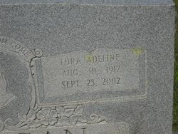

Lora Adeline Jennings Caligan
| Birth | : | 30 Aug 1912 |
| Death | : | 23 Sep 2002 |
| Burial | : | St. Mary the Virgin Churchyard, Henley-on-Thames, South Oxfordshire District, England |
| Coordinate | : | 51.5377790, -0.9017520 |
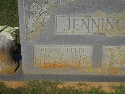
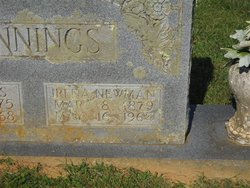
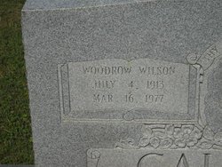
| Description | : | Lora Jennings Caligan, 90, of Salem, passed away Monday, September 23, 2002. She was preceded in death by her parents, Ellis and Irene Newman Jennings; her husband, Woodrow Caligan. Survivors include two sons and daughter-in-law, Perry Caligan of Salem, Larry and Martha Caligan of Martinsburg, W.Va.; two daughters and son-in-law, Roseanne Brown, Susan and Don Taylor, all of Salem; one sister, Bessie Bassetti of Alexandria, Va.; six grandchildren, Pam Ziskie, Joe Sammons, Donnie and David Taylor, Chip andTyler Brown; four great-grandchildren, Cody Ziskie, David Neill, Adam and Cameron Sammons; several nieces and nephews. She was dearly loved and will be... Read More |
frequently asked questions (FAQ):
-
Where is Lora Adeline Jennings Caligan's memorial?
Lora Adeline Jennings Caligan's memorial is located at: St. Mary the Virgin Churchyard, Henley-on-Thames, South Oxfordshire District, England.
-
When did Lora Adeline Jennings Caligan death?
Lora Adeline Jennings Caligan death on 23 Sep 2002 in
-
Where are the coordinates of the Lora Adeline Jennings Caligan's memorial?
Latitude: 51.5377790
Longitude: -0.9017520
Family Members:
Parent
Spouse
Siblings
Flowers:


Nearby Cemetories:
1. St. Mary the Virgin Churchyard
Henley-on-Thames, South Oxfordshire District, England
Coordinate: 51.5377790, -0.9017520
2. Christ Church
Henley-on-Thames, South Oxfordshire District, England
Coordinate: 51.5347880, -0.9032820
3. Holy Trinity Churchyard
Henley-on-Thames, South Oxfordshire District, England
Coordinate: 51.5338500, -0.9066600
4. St Margaret's Churchyard
Harpsden, South Oxfordshire District, England
Coordinate: 51.5219160, -0.9012270
5. Henley-on-Thames Cemetery
Henley-on-Thames, South Oxfordshire District, England
Coordinate: 51.5543570, -0.9271320
6. St. Nicholas' Churchyard
Rotherfield Greys, South Oxfordshire District, England
Coordinate: 51.5351017, -0.9541395
7. St. Mary the Virgin Churchyard
Fawley, Wycombe District, England
Coordinate: 51.5743000, -0.9140000
8. St. James's Churchyard
Bix and Assendon, South Oxfordshire District, England
Coordinate: 51.5610070, -0.9511270
9. St. Peter and St. Paul Churchyard
Shiplake, South Oxfordshire District, England
Coordinate: 51.4980750, -0.8963940
10. St Peter and St Paul Churchyard
Medmenham, Wycombe District, England
Coordinate: 51.5533800, -0.8407110
11. St. Mary's Churchyard
Wargrave, Wokingham Borough, England
Coordinate: 51.4998329, -0.8735808
12. Saint Mary the Virgin Churchyard
Hambleden, Wycombe District, England
Coordinate: 51.5773100, -0.8709500
13. All Saints Churchyard
Rotherfield Peppard, South Oxfordshire District, England
Coordinate: 51.5280531, -0.9725009
14. St. James' Old Churchyard
South Oxfordshire District, England
Coordinate: 51.5769360, -0.9532550
15. All Saints Churchyard
Dunsden Green, South Oxfordshire District, England
Coordinate: 51.4917730, -0.9461650
16. St. Pauls Highmoor Cross
Highmoor, South Oxfordshire District, England
Coordinate: 51.5532740, -0.9910110
17. St Mary the Virgin Churchyard
Hurley, Windsor and Maidenhead Royal Borough, England
Coordinate: 51.5492640, -0.8103620
18. Stonor Park Cemetery
Henley-on-Thames, South Oxfordshire District, England
Coordinate: 51.5967370, -0.9289660
19. St. Peter's Churchyard
Knowl Hill, Windsor and Maidenhead Royal Borough, England
Coordinate: 51.5093351, -0.8126725
20. St. Andrew's Churchyard
Sonning, Wokingham Borough, England
Coordinate: 51.4740300, -0.9131640
21. St Mary's Churchyard
Twyford, Wokingham Borough, England
Coordinate: 51.4763850, -0.8673190
22. St. John the Baptist Churchyard
Kidmore End, South Oxfordshire District, England
Coordinate: 51.5085170, -0.9951240
23. Kidmore End Cemetery
Kidmore End, South Oxfordshire District, England
Coordinate: 51.5071600, -0.9942160
24. St. Bartholomew's Churchyard
Nettlebed, South Oxfordshire District, England
Coordinate: 51.5752360, -0.9936230