
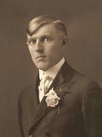
Louis Gerhart Deitering
| Birth | : | 3 Jan 1897 Remsen, Plymouth County, Iowa, USA |
| Death | : | 1 Oct 1951 Contra Costa County, California, USA |
| Burial | : | Saint Joseph Catholic Cemetery, San Pablo, Contra Costa County, USA |
| Coordinate | : | 37.9612700, -122.3336600 |
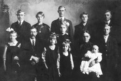
| Description | : | Louis was the son of Bernard Deitering and Caroline Lutmer. Louis had 14 brothers and sisters. Obituary and Funeral Card both state that Louis was buried at Saint Joseph Cemetery. His wife is also buried here. |
frequently asked questions (FAQ):
-
Where is Louis Gerhart Deitering's memorial?
Louis Gerhart Deitering's memorial is located at: Saint Joseph Catholic Cemetery, San Pablo, Contra Costa County, USA.
-
When did Louis Gerhart Deitering death?
Louis Gerhart Deitering death on 1 Oct 1951 in Contra Costa County, California, USA
-
Where are the coordinates of the Louis Gerhart Deitering's memorial?
Latitude: 37.9612700
Longitude: -122.3336600
Family Members:
Parent

Spouse
Siblings

Children

Flowers:


Nearby Cemetories:
1. Saint Joseph Catholic Cemetery
San Pablo, Contra Costa County, USA
Coordinate: 37.9612700, -122.3336600
2. Saint Pauls Cemetery (Defunct)
San Pablo, Contra Costa County, USA
Coordinate: 37.9563332, -122.3430099
3. Salesian Cemetery
Richmond, Contra Costa County, USA
Coordinate: 37.9532650, -122.3401230
4. Rolling Hills Memorial Park
Richmond, Contra Costa County, USA
Coordinate: 37.9756012, -122.3146973
5. Sunset View Cemetery
El Cerrito, Contra Costa County, USA
Coordinate: 37.9077721, -122.2871017
6. Golden Gate Mausoleum and Columbaria
El Cerrito, Contra Costa County, USA
Coordinate: 37.9073150, -122.2857220
7. Golden Gate Fields
Albany, Alameda County, USA
Coordinate: 37.8854000, -122.3117000
8. Northbrae Community Church Columbarium
Berkeley, Alameda County, USA
Coordinate: 37.8905500, -122.2763200
9. Gan Shalom Cemetery
Contra Costa County, USA
Coordinate: 37.9528122, -122.1975098
10. San Quentin Prison Cemetery
San Rafael, Marin County, USA
Coordinate: 37.9436480, -122.4883760
11. Angel Island Cemetery (defunct)
Tiburon, Marin County, USA
Coordinate: 37.8621830, -122.4325920
12. Rags Gravesite
Crockett, Contra Costa County, USA
Coordinate: 38.0561765, -122.2257217
13. Mare Island Cemetery
Vallejo, Solano County, USA
Coordinate: 38.0796738, -122.2527008
14. St. Stephen's Episcopal Church Memorial Garden
Belvedere, Marin County, USA
Coordinate: 37.8767515, -122.4712901
15. Saint Stephens Episcopal Church Memorial Garden
Orinda, Contra Costa County, USA
Coordinate: 37.8982650, -122.1729170
16. Saint Mary's Cemetery
Oakland, Alameda County, USA
Coordinate: 37.8349991, -122.2418976
17. Glen Cove Sacred Indian Burial Grounds
Vallejo, Solano County, USA
Coordinate: 38.0680620, -122.2064640
18. Chapel of Memories Columbarium
Oakland, Alameda County, USA
Coordinate: 37.8310471, -122.2480927
19. Home of Eternity Cemetery
Oakland, Alameda County, USA
Coordinate: 37.8322970, -122.2448270
20. Chapel of the Chimes Columbarium and Mausoleum
Oakland, Alameda County, USA
Coordinate: 37.8318863, -122.2456894
21. Mountain View Cemetery
Oakland, Alameda County, USA
Coordinate: 37.8327600, -122.2395200
22. Yerba Buena Island Cemetery (Defunct)
San Francisco, San Francisco County, USA
Coordinate: 37.8127420, -122.3707880
23. Mission San Rafael Arcangel Cemetery
San Rafael, Marin County, USA
Coordinate: 37.9744330, -122.5280570
24. Lafayette-Orinda Presbyterian Church Garden
Contra Costa County, USA
Coordinate: 37.8866040, -122.1606950