


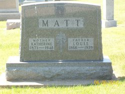
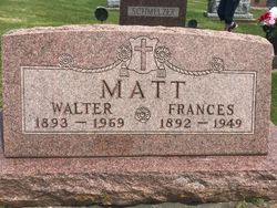
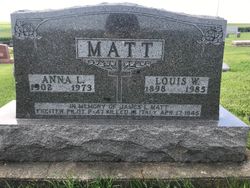
Louis William Matt
| Birth | : | 10 Aug 1866 Farmersburg, Clayton County, Iowa, USA |
| Death | : | 27 Nov 1939 Guttenberg, Clayton County, Iowa, USA |
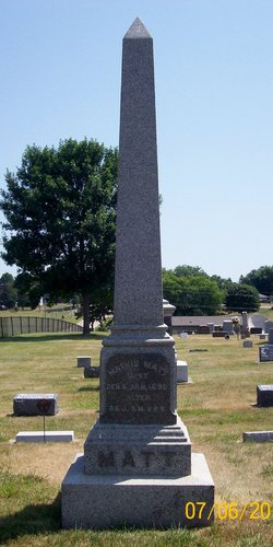
| Burial | : | Saint Joseph Cemetery, Garnavillo, Clayton County, USA |
| Coordinate | : | 42.8628006, -91.2502975 |
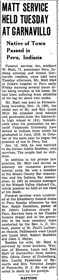
| Description | : | Guttenberg Press, Thursday, November 30, 1939, p1 LOUIS MATT, 73, DIES ON MONDAY Louis Matt, retired Farmersburg township farmer who had lived here for the past eighteen years, died in his home Monday afternoon following a lingering illness. Funeral services are to be held at 9 o'clock Thursday morning in St. Mary's Catholic Church here, with burial in Garnavillo. Mr. [Louis] Matt had been in ailing health for about four years, and became critically ill twelve days before his death. He was 73 years old. He was born Aug. 10, 1866, on a farm in Farmbersburg township. He was married at the... Read More |
frequently asked questions (FAQ):
-
Where is Louis William Matt's memorial?
Louis William Matt's memorial is located at: Saint Joseph Cemetery, Garnavillo, Clayton County, USA.
-
When did Louis William Matt death?
Louis William Matt death on 27 Nov 1939 in Guttenberg, Clayton County, Iowa, USA
-
Where are the coordinates of the Louis William Matt's memorial?
Latitude: 42.8628006
Longitude: -91.2502975
Family Members:
Parent

Spouse
Siblings
Children

Flowers:


Nearby Cemetories:
1. Saint Joseph Cemetery
Garnavillo, Clayton County, USA
Coordinate: 42.8628006, -91.2502975
2. Garnavillo Community Cemetery
Garnavillo, Clayton County, USA
Coordinate: 42.8656000, -91.2422100
3. Garnavillo Cemetery
Garnavillo, Clayton County, USA
Coordinate: 42.8660300, -91.2390100
4. McClelland Cemetery
Garnavillo, Clayton County, USA
Coordinate: 42.8249879, -91.2084641
5. Clayton Center Cemetery
Clayton Center, Clayton County, USA
Coordinate: 42.8841705, -91.3225021
6. Zion Lutheran Cemetery
Clayton Center, Clayton County, USA
Coordinate: 42.8841705, -91.3249969
7. Pioneer Rock Cemetery
Ceres, Clayton County, USA
Coordinate: 42.8230591, -91.1863937
8. Clayton Cemetery
Clayton, Clayton County, USA
Coordinate: 42.9043999, -91.1641998
9. Saint Michael Cemetery
Clayton County, USA
Coordinate: 42.8055992, -91.1802979
10. County Home Cemetery
Clayton Center, Clayton County, USA
Coordinate: 42.8916702, -91.3499985
11. Tangeman Family Cemetery
Garnavillo, Clayton County, USA
Coordinate: 42.8580000, -91.1420000
12. Krumm Cemetery
Garber, Clayton County, USA
Coordinate: 42.7913760, -91.3023559
13. Colony Catholic Cemetery (Defunct)
Read Township, Clayton County, USA
Coordinate: 42.8830000, -91.3580000
14. Borcherding Cemetery
Jefferson Township, Clayton County, USA
Coordinate: 42.8182983, -91.1414032
15. National Cemetery
National, Clayton County, USA
Coordinate: 42.9536018, -91.2902985
16. Meenan Cemetery
Communia, Clayton County, USA
Coordinate: 42.7999862, -91.3584693
17. Storck Cemetery
Guttenberg, Clayton County, USA
Coordinate: 42.7694335, -91.1834638
18. Saint Paula Cemetery
Osterdock, Clayton County, USA
Coordinate: 42.7635994, -91.1992035
19. Old Garber Cemetery
Garber, Clayton County, USA
Coordinate: 42.7560005, -91.2580032
20. Elkader Cemetery
Elkader, Clayton County, USA
Coordinate: 42.8541718, -91.4000015
21. Hartman Cemetery
Cox Creek Township, Clayton County, USA
Coordinate: 42.8155360, -91.3880840
22. Harford Cemetery
Wyalusing, Grant County, USA
Coordinate: 42.9401000, -91.1401800
23. Saint Josephs Cemetery
Elkader, Clayton County, USA
Coordinate: 42.8488998, -91.4021988
24. Communia Cemetery
Volga Township, Clayton County, USA
Coordinate: 42.7868996, -91.3630981