


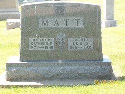
Mathias Matt
| Birth | : | 11 Jul 1823 Mauren, Liechtenstein |
| Death | : | 9 Jan 1890 Garnavillo, Clayton County, Iowa, USA |
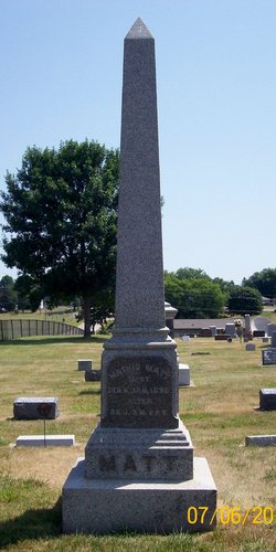
| Burial | : | Garnavillo Community Cemetery, Garnavillo, Clayton County, USA |
| Coordinate | : | 42.8656000, -91.2422100 |
| Inscription | : | MATHIS MATT GEST DEN.9 JAN 1890 ALTER 66 J. 5 M. 28 T. |
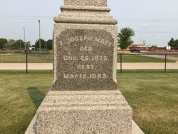
| Description | : | When Mathias Matt and his wife Elizabeth immigrated to America in 1852, his younger brother, Franz Josef "Joseph" Matt, who was about twenty years old, also came with him. Eventually Joseph was married and he settled in the Volga Twp near Elkport, thus becoming known as "the water Matt" to distinguish him from his older brother, Mathias, who was called, "the prairie Matt." About twelve years later in 1864/65, a first cousin of Mathias and Joseph immigrated to America; Andreas Matt and his second wife, Josephine (Lampert) Matt, settled on a farm in Jefferson... Read More |
frequently asked questions (FAQ):
-
Where is Mathias Matt's memorial?
Mathias Matt's memorial is located at: Garnavillo Community Cemetery, Garnavillo, Clayton County, USA.
-
When did Mathias Matt death?
Mathias Matt death on 9 Jan 1890 in Garnavillo, Clayton County, Iowa, USA
-
Where are the coordinates of the Mathias Matt's memorial?
Latitude: 42.8656000
Longitude: -91.2422100
Family Members:
Parent
Spouse

Siblings
Children
Flowers:


Nearby Cemetories:
1. Garnavillo Community Cemetery
Garnavillo, Clayton County, USA
Coordinate: 42.8656000, -91.2422100
2. Garnavillo Cemetery
Garnavillo, Clayton County, USA
Coordinate: 42.8660300, -91.2390100
3. Saint Joseph Cemetery
Garnavillo, Clayton County, USA
Coordinate: 42.8628006, -91.2502975
4. McClelland Cemetery
Garnavillo, Clayton County, USA
Coordinate: 42.8249879, -91.2084641
5. Pioneer Rock Cemetery
Ceres, Clayton County, USA
Coordinate: 42.8230591, -91.1863937
6. Clayton Center Cemetery
Clayton Center, Clayton County, USA
Coordinate: 42.8841705, -91.3225021
7. Zion Lutheran Cemetery
Clayton Center, Clayton County, USA
Coordinate: 42.8841705, -91.3249969
8. Clayton Cemetery
Clayton, Clayton County, USA
Coordinate: 42.9043999, -91.1641998
9. Tangeman Family Cemetery
Garnavillo, Clayton County, USA
Coordinate: 42.8580000, -91.1420000
10. Saint Michael Cemetery
Clayton County, USA
Coordinate: 42.8055992, -91.1802979
11. County Home Cemetery
Clayton Center, Clayton County, USA
Coordinate: 42.8916702, -91.3499985
12. Krumm Cemetery
Garber, Clayton County, USA
Coordinate: 42.7913760, -91.3023559
13. Colony Catholic Cemetery (Defunct)
Read Township, Clayton County, USA
Coordinate: 42.8830000, -91.3580000
14. Borcherding Cemetery
Jefferson Township, Clayton County, USA
Coordinate: 42.8182983, -91.1414032
15. National Cemetery
National, Clayton County, USA
Coordinate: 42.9536018, -91.2902985
16. Storck Cemetery
Guttenberg, Clayton County, USA
Coordinate: 42.7694335, -91.1834638
17. Harford Cemetery
Wyalusing, Grant County, USA
Coordinate: 42.9401000, -91.1401800
18. Saint Paula Cemetery
Osterdock, Clayton County, USA
Coordinate: 42.7635994, -91.1992035
19. Meenan Cemetery
Communia, Clayton County, USA
Coordinate: 42.7999862, -91.3584693
20. Norwegian Church Cemetery
McGregor, Clayton County, USA
Coordinate: 42.9644400, -91.1764100
21. Old Garber Cemetery
Garber, Clayton County, USA
Coordinate: 42.7560005, -91.2580032
22. Elkader Cemetery
Elkader, Clayton County, USA
Coordinate: 42.8541718, -91.4000015
23. Bagley Cemetery
Bagley, Grant County, USA
Coordinate: 42.9019012, -91.0907974
24. First Evangelical Lutheran Church Cemetery
McGregor, Clayton County, USA
Coordinate: 42.9718000, -91.1760000