
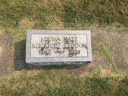

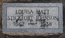
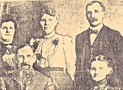
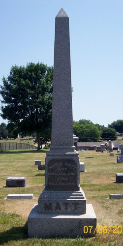
Louisa Elizabeth “Eliza” Matt Johnson
| Birth | : | 9 Oct 1862 Farmersburg, Clayton County, Iowa, USA |
| Death | : | 12 Sep 1938 Garnavillo, Clayton County, Iowa, USA |
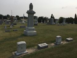
| Burial | : | Garnavillo Community Cemetery, Garnavillo, Clayton County, USA |
| Coordinate | : | 42.8656000, -91.2422100 |
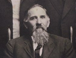
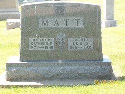
| Description | : | Louisa Elizabeth "Eliza" Matt was born in Farmersburg Twp, Clayton Co., Iowa, on 9 Oct 1862, the third of five children that would bless the home of Mathias and Elizabeth Louisa (Potes) Matt. Her father had emigrated when he was twenty-seven and single from Mauren, Liechtenstein, and settled in the area north of Garnavillo, Iowa. Eliza's mother was a native of Mecklenburg-Schwerein, Germany, and had emigrated from Germany with her parents in the early 1850s as well. Her parents were married in about 1854, and began having a family the following year. Eliza's two older... Read More |
frequently asked questions (FAQ):
-
Where is Louisa Elizabeth “Eliza” Matt Johnson's memorial?
Louisa Elizabeth “Eliza” Matt Johnson's memorial is located at: Garnavillo Community Cemetery, Garnavillo, Clayton County, USA.
-
When did Louisa Elizabeth “Eliza” Matt Johnson death?
Louisa Elizabeth “Eliza” Matt Johnson death on 12 Sep 1938 in Garnavillo, Clayton County, Iowa, USA
-
Where are the coordinates of the Louisa Elizabeth “Eliza” Matt Johnson's memorial?
Latitude: 42.8656000
Longitude: -91.2422100
Family Members:
Parent

Spouse
Siblings
Children
Flowers:


Nearby Cemetories:
1. Garnavillo Community Cemetery
Garnavillo, Clayton County, USA
Coordinate: 42.8656000, -91.2422100
2. Garnavillo Cemetery
Garnavillo, Clayton County, USA
Coordinate: 42.8660300, -91.2390100
3. Saint Joseph Cemetery
Garnavillo, Clayton County, USA
Coordinate: 42.8628006, -91.2502975
4. McClelland Cemetery
Garnavillo, Clayton County, USA
Coordinate: 42.8249879, -91.2084641
5. Pioneer Rock Cemetery
Ceres, Clayton County, USA
Coordinate: 42.8230591, -91.1863937
6. Clayton Center Cemetery
Clayton Center, Clayton County, USA
Coordinate: 42.8841705, -91.3225021
7. Zion Lutheran Cemetery
Clayton Center, Clayton County, USA
Coordinate: 42.8841705, -91.3249969
8. Clayton Cemetery
Clayton, Clayton County, USA
Coordinate: 42.9043999, -91.1641998
9. Tangeman Family Cemetery
Garnavillo, Clayton County, USA
Coordinate: 42.8580000, -91.1420000
10. Saint Michael Cemetery
Clayton County, USA
Coordinate: 42.8055992, -91.1802979
11. County Home Cemetery
Clayton Center, Clayton County, USA
Coordinate: 42.8916702, -91.3499985
12. Krumm Cemetery
Garber, Clayton County, USA
Coordinate: 42.7913760, -91.3023559
13. Colony Catholic Cemetery (Defunct)
Read Township, Clayton County, USA
Coordinate: 42.8830000, -91.3580000
14. Borcherding Cemetery
Jefferson Township, Clayton County, USA
Coordinate: 42.8182983, -91.1414032
15. National Cemetery
National, Clayton County, USA
Coordinate: 42.9536018, -91.2902985
16. Storck Cemetery
Guttenberg, Clayton County, USA
Coordinate: 42.7694335, -91.1834638
17. Harford Cemetery
Wyalusing, Grant County, USA
Coordinate: 42.9401000, -91.1401800
18. Saint Paula Cemetery
Osterdock, Clayton County, USA
Coordinate: 42.7635994, -91.1992035
19. Meenan Cemetery
Communia, Clayton County, USA
Coordinate: 42.7999862, -91.3584693
20. Norwegian Church Cemetery
McGregor, Clayton County, USA
Coordinate: 42.9644400, -91.1764100
21. Old Garber Cemetery
Garber, Clayton County, USA
Coordinate: 42.7560005, -91.2580032
22. Elkader Cemetery
Elkader, Clayton County, USA
Coordinate: 42.8541718, -91.4000015
23. Bagley Cemetery
Bagley, Grant County, USA
Coordinate: 42.9019012, -91.0907974
24. First Evangelical Lutheran Church Cemetery
McGregor, Clayton County, USA
Coordinate: 42.9718000, -91.1760000