
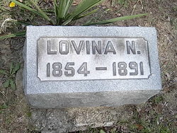
Lovina A Brown Hodge
| Birth | : | 7 May 1854 Gustavus, Trumbull County, Ohio, USA |
| Death | : | 1891 |
| Burial | : | Randolph Memory Gardens, Rock Mills, Randolph County, USA |
| Coordinate | : | 33.1535988, -85.3107986 |
| Description | : | >daughter of Nelson Clark Brown (1825-1905 OH) and Sarah Ann Walling (b 1828 NY) >granddaughter of Arial D Brown (b 1794 CT) and Elizabeth Ward (b VT) >granddaughter of Charles Walling (1798 NY--1888 OH) and Clarissa Northway (b 1801) >great-granddaughter of Simeon Walling (b 1766) and Sarah Whitmarsh, dau of Samuel Whitmarsh |
frequently asked questions (FAQ):
-
Where is Lovina A Brown Hodge's memorial?
Lovina A Brown Hodge's memorial is located at: Randolph Memory Gardens, Rock Mills, Randolph County, USA.
-
When did Lovina A Brown Hodge death?
Lovina A Brown Hodge death on 1891 in
-
Where are the coordinates of the Lovina A Brown Hodge's memorial?
Latitude: 33.1535988
Longitude: -85.3107986
Family Members:
Parent
Spouse
Siblings
Children

Flowers:


Nearby Cemetories:
1. Randolph Memory Gardens
Rock Mills, Randolph County, USA
Coordinate: 33.1535988, -85.3107986
2. Rock Mills Missionary Baptist Church Cemetery
Randolph County, USA
Coordinate: 33.1570530, -85.3077420
3. Old Salem Primitive Baptist Cemetery
Bacon Level, Randolph County, USA
Coordinate: 33.1375200, -85.3103400
4. Rock Mills Cemetery
Rock Mills, Randolph County, USA
Coordinate: 33.1644300, -85.2848000
5. Center Chapel Baptist Church Cemetery
Randolph County, USA
Coordinate: 33.1735460, -85.3333320
6. Wehadkee Primitive Baptist Church Cemetery
Rock Mills, Randolph County, USA
Coordinate: 33.1694120, -85.2806240
7. Fellowship Baptist Church Cemetery
Bacon Level, Randolph County, USA
Coordinate: 33.1270650, -85.2868900
8. Forest Home Christian Church Cemetery
Springfield, Randolph County, USA
Coordinate: 33.1927400, -85.3155500
9. Booger Hill Cemetery
Roanoke, Randolph County, USA
Coordinate: 33.1481018, -85.3610992
10. Macedonia Cemetery
Roanoke, Randolph County, USA
Coordinate: 33.1802040, -85.3505050
11. Bethany Lime Cemetery
Randolph County, USA
Coordinate: 33.1579680, -85.2596960
12. Pike Family Cemetery
Randolph County, USA
Coordinate: 33.1960270, -85.3199710
13. East Roanoke Cemetery
Roanoke, Randolph County, USA
Coordinate: 33.1432991, -85.3644028
14. Cedarwood Cemetery
Roanoke, Randolph County, USA
Coordinate: 33.1519012, -85.3681030
15. Lebanon Christian Church Cemetery
Springfield, Randolph County, USA
Coordinate: 33.1897400, -85.3500700
16. Roanoke Baptist Church Cemetery
Roanoke, Randolph County, USA
Coordinate: 33.1506600, -85.3730260
17. Springfield Methodist Church Cemetery
Randolph County, USA
Coordinate: 33.2120830, -85.3185290
18. Springfield Baptist Church Cemetery
Springfield, Randolph County, USA
Coordinate: 33.2129900, -85.3164140
19. Lanes Chapel Methodist Church Cemetery
Roanoke, Randolph County, USA
Coordinate: 33.1129210, -85.3645760
20. Lee Family Cemetery
Rock Mills, Randolph County, USA
Coordinate: 33.2107200, -85.2834300
21. Mount Pisgah Baptist Church Cemetery
Roanoke, Randolph County, USA
Coordinate: 33.1592510, -85.3901760
22. Pittman Family Cemetery
Randolph County, USA
Coordinate: 33.2203000, -85.3095300
23. Pleasant Grove Cemetery
Heard County, USA
Coordinate: 33.1528015, -85.2294006
24. Pittman Cemetery
Heard County, USA
Coordinate: 33.1866989, -85.2394028