
| Birth | : | 31 Jan 1932 Carroll, Carroll County, Iowa, USA |
| Death | : | 9 Jul 2017 Council Bluffs, Pottawattamie County, Iowa, USA |
| Burial | : | Ridgewood Cemetery, Council Bluffs, Pottawattamie County, USA |
| Coordinate | : | 41.2694016, -95.8272018 |
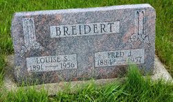
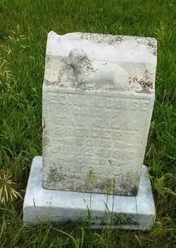
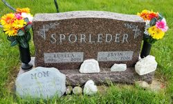
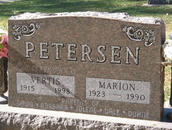
| Description | : | Lucretia M. “Pat” Lindhorst, age 85, passed away July 9, 2017, at CHI-Mercy. Pat was born January 31, 1932, in Carroll, Iowa, to the late Fred and Louisa (Topp) Breidert. She was united in marriage to Antone Lindhorst, who passed away in 2000. Pat was an active member of Timothy Lutheran Church. In addition to her parents, she was preceded in death by her daughter, Nancy Maher; granddaughter, Corrine Ritterbush; sisters, Josephine Johnson, Marian Petersen, Luella Sporleder; brother, Fred Breidert. She is survived by her family: daughters, Betty (John) Davis, of Bennington, Neb., Patsy Flieth; sons, Steve (Sandy) Lindhorst, Dale (Susan) Lindhorst,... Read More |
frequently asked questions (FAQ):
-
Where is Lucretia Martina “Pat” Breidert Lindhorst's memorial?
Lucretia Martina “Pat” Breidert Lindhorst's memorial is located at: Ridgewood Cemetery, Council Bluffs, Pottawattamie County, USA.
-
When did Lucretia Martina “Pat” Breidert Lindhorst death?
Lucretia Martina “Pat” Breidert Lindhorst death on 9 Jul 2017 in Council Bluffs, Pottawattamie County, Iowa, USA
-
Where are the coordinates of the Lucretia Martina “Pat” Breidert Lindhorst's memorial?
Latitude: 41.2694016
Longitude: -95.8272018
Family Members:
Parent

Spouse
Siblings
Children
Flowers:


Nearby Cemetories:
1. Ridgewood Cemetery
Council Bluffs, Pottawattamie County, USA
Coordinate: 41.2694016, -95.8272018
2. Walnut Hill Cemetery
Council Bluffs, Pottawattamie County, USA
Coordinate: 41.2719002, -95.8255997
3. Bikhor Cholim Cemetery
Council Bluffs, Pottawattamie County, USA
Coordinate: 41.2703670, -95.8229350
4. Oak Hill Cemetery
Council Bluffs, Pottawattamie County, USA
Coordinate: 41.2700900, -95.8226400
5. Memorial Park Cemetery
Council Bluffs, Pottawattamie County, USA
Coordinate: 41.2644005, -95.8261032
6. Saint Joseph Cemetery
Council Bluffs, Pottawattamie County, USA
Coordinate: 41.2722015, -95.8208008
7. Green Valley Cemetery
Council Bluffs, Pottawattamie County, USA
Coordinate: 41.2743988, -95.8225021
8. Cedar Lawn Cemetery
Council Bluffs, Pottawattamie County, USA
Coordinate: 41.2694016, -95.8182983
9. Clark Cemetery
Pottawattamie County, USA
Coordinate: 41.2551610, -95.8223390
10. Fairview Cemetery
Council Bluffs, Pottawattamie County, USA
Coordinate: 41.2703018, -95.8480988
11. Garner Cemetery
Council Bluffs, Pottawattamie County, USA
Coordinate: 41.2956161, -95.8001709
12. Stoker-Graybill Cemetery
Council Bluffs, Pottawattamie County, USA
Coordinate: 41.2532620, -95.7751770
13. Maple Grove Cemetery
Council Bluffs, Pottawattamie County, USA
Coordinate: 41.2265560, -95.8187100
14. Evans Cemetery
Crescent, Pottawattamie County, USA
Coordinate: 41.3255997, -95.8368988
15. Lewis Township Cemetery
Council Bluffs, Pottawattamie County, USA
Coordinate: 41.2117004, -95.7938995
16. Gregg Cemetery
Weston, Pottawattamie County, USA
Coordinate: 41.3330000, -95.7931000
17. Council Point Cemetery
Council Bluffs, Pottawattamie County, USA
Coordinate: 41.2110830, -95.8788610
18. Hazel Dell Cemetery
Council Bluffs, Pottawattamie County, USA
Coordinate: 41.3489723, -95.7939911
19. Trinity Cathedral Columbarium
Omaha, Douglas County, USA
Coordinate: 41.2603900, -95.9393660
20. Saint Columbanus Cemetery
Weston, Pottawattamie County, USA
Coordinate: 41.3429440, -95.7435260
21. Crescent Cemetery
Crescent, Pottawattamie County, USA
Coordinate: 41.3664894, -95.8566208
22. Prospect Hill Cemetery
Omaha, Douglas County, USA
Coordinate: 41.2780991, -95.9593964
23. First Central Congregational Columbarium
Omaha, Douglas County, USA
Coordinate: 41.2563456, -95.9658365
24. Nash Chapel Crypt
Omaha, Douglas County, USA
Coordinate: 41.2665090, -95.9721790