
| Birth | : | 25 Sep 1922 Axtell, Marshall County, Kansas, USA |
| Death | : | 23 Mar 2012 Humboldt, Richardson County, Nebraska, USA |
| Burial | : | Humboldt Cemetery, Humboldt, Richardson County, USA |
| Coordinate | : | 40.1610985, -95.9578018 |
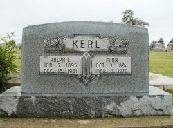
| Description | : | Luella Mina (Kerl) Fankhauser, 89, of Humboldt, Nebraska, was born on September 25, 1922, in Axtell, Kansas to Ralph Lemarr and Mina (Cook) Kerl. She attended Began Country School District # 5 near Dubois, Nebraska and graduated from Pawnee City High School with the class of 1940. Luella taught at country schools until training and becoming a skilled welder at the Martin Bomber plant in Omaha in 1943 as her part of the war effort. She was quoted "I went because I wanted to win the war. We were a very patriotic generation." On February 19, 1944, Luella was united... Read More |
frequently asked questions (FAQ):
-
Where is Luella Mina Kerl Fankhauser's memorial?
Luella Mina Kerl Fankhauser's memorial is located at: Humboldt Cemetery, Humboldt, Richardson County, USA.
-
When did Luella Mina Kerl Fankhauser death?
Luella Mina Kerl Fankhauser death on 23 Mar 2012 in Humboldt, Richardson County, Nebraska, USA
-
Where are the coordinates of the Luella Mina Kerl Fankhauser's memorial?
Latitude: 40.1610985
Longitude: -95.9578018
Family Members:
Parent

Spouse

Siblings
Flowers:


Nearby Cemetories:
1. Humboldt Cemetery
Humboldt, Richardson County, USA
Coordinate: 40.1610985, -95.9578018
2. Longbranch Cemetery
Humboldt, Richardson County, USA
Coordinate: 40.1996000, -95.9740000
3. Lynchburg Cemetery
Humboldt, Richardson County, USA
Coordinate: 40.1306000, -95.9068985
4. Standerford Cemetery
Humboldt, Richardson County, USA
Coordinate: 40.2110000, -95.9656000
5. Dry Branch Pioneer Cemetery
Richardson County, USA
Coordinate: 40.1292000, -96.0100021
6. Bohemian Cemetery
Richardson County, USA
Coordinate: 40.1175003, -95.9955978
7. Bohemian Cemetery
Table Rock, Pawnee County, USA
Coordinate: 40.1786003, -96.0374985
8. Starr Cemetery
Dawson, Richardson County, USA
Coordinate: 40.1464005, -95.8692017
9. Mound Cemetery
Humboldt, Richardson County, USA
Coordinate: 40.1960983, -95.8602982
10. Saint Marys Cemetery
Dawson, Richardson County, USA
Coordinate: 40.1307983, -95.8414001
11. Heim Cemetery
Dawson, Richardson County, USA
Coordinate: 40.1380997, -95.8328018
12. Saint Johns Cemetery
Table Rock, Pawnee County, USA
Coordinate: 40.2148000, -96.0657000
13. East Amish Cemetery
Table Rock, Pawnee County, USA
Coordinate: 40.1310000, -96.0854000
14. Four Mile Cemetery
Humboldt, Richardson County, USA
Coordinate: 40.0589000, -95.9455000
15. Pleasant View Cemetery
Auburn, Nemaha County, USA
Coordinate: 40.2681007, -95.9163971
16. Table Rock Cemetery
Table Rock, Pawnee County, USA
Coordinate: 40.1791400, -96.1037400
17. Iliff Cemetery
Dawson, Richardson County, USA
Coordinate: 40.1241989, -95.8127975
18. Athens Cemetery
Richardson County, USA
Coordinate: 40.0449982, -95.9852982
19. Pleasant Hill Cemetery
Richardson County, USA
Coordinate: 40.0471992, -95.9075012
20. Mount Zion Cemetery
Nemaha County, USA
Coordinate: 40.2761002, -96.0113983
21. Saint James Lutheran Cemetery
Nemaha County, USA
Coordinate: 40.2757500, -96.0161500
22. Liberty Township Cemetery
Verdon, Richardson County, USA
Coordinate: 40.1597200, -95.7664100
23. Trinity Lutheran Cemetery
Nemaha County, USA
Coordinate: 40.3058014, -96.0093994
24. Clear Creek Cemetery
Table Rock, Pawnee County, USA
Coordinate: 40.2193985, -96.1391983