
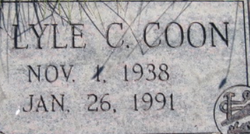
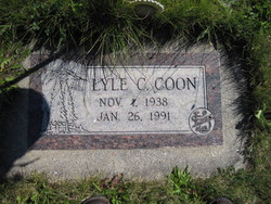
Lyle Clifton Coon
| Birth | : | 1 Nov 1938 Linton, Emmons County, North Dakota, USA |
| Death | : | 26 Jan 1991 Libby, Lincoln County, Montana, USA |
| Burial | : | St Matthias Churchyard, Panmure, Auckland Council, New Zealand |
| Coordinate | : | -36.9053300, 174.8577200 |
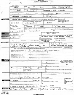
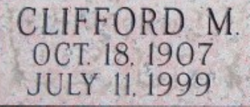
| Description | : | Montana, County Births and Deaths Name: Lyle C. Coon Gender: Male Death Age: 52 Birth Date: 1 Nov 1938 Birth Place: Linton, North Dakota Death Date: 26 Jan 1991 Death Place: Libby, Lincoln, Montana Father: Clifford Coon Mother: Lily Coon Spouse: Myrna Montana, Death Index Name: Lyle C Coon Birth Year: abt 1939 Death Date: 26 Jan 1991 Death County: Lincoln Age at Death: 52 U.S., Social Security Death Index Name: Lyle C. Coon BORN: 1 Nov 1938 Died: ... Read More |
frequently asked questions (FAQ):
-
Where is Lyle Clifton Coon's memorial?
Lyle Clifton Coon's memorial is located at: St Matthias Churchyard, Panmure, Auckland Council, New Zealand.
-
When did Lyle Clifton Coon death?
Lyle Clifton Coon death on 26 Jan 1991 in Libby, Lincoln County, Montana, USA
-
Where are the coordinates of the Lyle Clifton Coon's memorial?
Latitude: -36.9053300
Longitude: 174.8577200
Family Members:
Parent
Siblings

Flowers:


Nearby Cemetories:
1. St Matthias Churchyard
Panmure, Auckland Council, New Zealand
Coordinate: -36.9053300, 174.8577200
2. St. Patrick's Roman Catholic Church Cemetery
Panmure, Auckland Council, New Zealand
Coordinate: -36.9029680, 174.8564960
3. Point England Presbyterian Cemetery
Point England, Auckland Council, New Zealand
Coordinate: -36.8823420, 174.8601550
4. Pakuranga Methodist Cemetery
Pakuranga, Auckland Council, New Zealand
Coordinate: -36.9054000, 174.8914900
5. Holy Trinity Memorial Park
Ōtāhūhū, Auckland Council, New Zealand
Coordinate: -36.9374510, 174.8448580
6. St. John’s College Graveyard
Saint Johns, Auckland Council, New Zealand
Coordinate: -36.8738169, 174.8416826
7. Otahuhu Public Cemetery
Ōtāhūhū, Auckland Council, New Zealand
Coordinate: -36.9377500, 174.8432390
8. Howick Historical Village
Pakuranga, Auckland Council, New Zealand
Coordinate: -36.9067680, 174.9027080
9. St. Thomas Churchyard
Tamaki, Auckland Council, New Zealand
Coordinate: -36.8675590, 174.8460560
10. St. Joseph and St. Joachim Catholic Cemetery
Ōtāhūhū, Auckland Council, New Zealand
Coordinate: -36.9436100, 174.8490100
11. Purewa Cemetery
Meadowbank, Auckland Council, New Zealand
Coordinate: -36.8674300, 174.8297900
12. Nixon Memorial
Ōtāhūhū, Auckland Council, New Zealand
Coordinate: -36.9499366, 174.8449909
13. St. Andrew Presbyterian Cemetery
Howick, Auckland Council, New Zealand
Coordinate: -36.8989900, 174.9201600
14. Ōrākei (Rautara St) Urupā
Orakei, Auckland Council, New Zealand
Coordinate: -36.8610770, 174.8188960
15. Waikaraka Cemetery
Ōnehunga, Auckland Council, New Zealand
Coordinate: -36.9297140, 174.7967170
16. St. John's Church Cemetery
East Tamaki, Auckland Council, New Zealand
Coordinate: -36.9522250, 174.8964540
17. Our Lady of the Assumption Catholic Church
Ōnehunga, Auckland Council, New Zealand
Coordinate: -36.9223690, 174.7884530
18. Onehunga Catholic Cemetery
Ōnehunga, Auckland Council, New Zealand
Coordinate: -36.9224360, 174.7884560
19. Our Lady Star of the Sea Parish Cemetery
Howick, Auckland Council, New Zealand
Coordinate: -36.8932940, 174.9307940
20. St. Peter's Anglican Cemetery
Ōnehunga, Auckland Council, New Zealand
Coordinate: -36.9227113, 174.7847550
21. All Saints Cemetery
Howick, Auckland Council, New Zealand
Coordinate: -36.8954260, 174.9337600
22. St. John's Presbyterian Church Cemetery
Papatoetoe, Auckland Council, New Zealand
Coordinate: -36.9674185, 174.8598178
23. Howick Cemetery
Howick, Auckland Council, New Zealand
Coordinate: -36.9040400, 174.9380500
24. Savage Memorial
Auckland, Auckland Council, New Zealand
Coordinate: -36.8462500, 174.8259300