
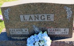
Mabel Lucinda Seeland Lange
| Birth | : | 9 Jun 1910 Saint Olaf, Clayton County, Iowa, USA |
| Death | : | 16 Apr 1995 Elkader, Clayton County, Iowa, USA |
| Burial | : | Clayton Center Cemetery, Clayton Center, Clayton County, USA |
| Coordinate | : | 42.8841705, -91.3225021 |
| Description | : | Daughter of William Seeland and Sophia Gottchalk. She m1. Ralph Wolfe in 1929 and had daughter Betty. She m2. Leland Lange in 1936 and had son Valdean. Mabel worked several years at Muters Speaker Plant in Guttenberg, and later at Pedretti's Bakery in Elkader. Mabel and Leland spent their married life together farming the family farm. |
frequently asked questions (FAQ):
-
Where is Mabel Lucinda Seeland Lange's memorial?
Mabel Lucinda Seeland Lange's memorial is located at: Clayton Center Cemetery, Clayton Center, Clayton County, USA.
-
When did Mabel Lucinda Seeland Lange death?
Mabel Lucinda Seeland Lange death on 16 Apr 1995 in Elkader, Clayton County, Iowa, USA
-
Where are the coordinates of the Mabel Lucinda Seeland Lange's memorial?
Latitude: 42.8841705
Longitude: -91.3225021
Family Members:
Parent

Spouse

Siblings

Children

Flowers:


Nearby Cemetories:
1. Clayton Center Cemetery
Clayton Center, Clayton County, USA
Coordinate: 42.8841705, -91.3225021
2. Zion Lutheran Cemetery
Clayton Center, Clayton County, USA
Coordinate: 42.8841705, -91.3249969
3. County Home Cemetery
Clayton Center, Clayton County, USA
Coordinate: 42.8916702, -91.3499985
4. Colony Catholic Cemetery (Defunct)
Read Township, Clayton County, USA
Coordinate: 42.8830000, -91.3580000
5. Saint Joseph Cemetery
Garnavillo, Clayton County, USA
Coordinate: 42.8628006, -91.2502975
6. Garnavillo Community Cemetery
Garnavillo, Clayton County, USA
Coordinate: 42.8656000, -91.2422100
7. Garnavillo Cemetery
Garnavillo, Clayton County, USA
Coordinate: 42.8660300, -91.2390100
8. Elkader Cemetery
Elkader, Clayton County, USA
Coordinate: 42.8541718, -91.4000015
9. Saint Josephs Cemetery
Elkader, Clayton County, USA
Coordinate: 42.8488998, -91.4021988
10. Farmersburg-Wagner Cemetery
Farmersburg, Clayton County, USA
Coordinate: 42.9481010, -91.3700027
11. National Cemetery
National, Clayton County, USA
Coordinate: 42.9536018, -91.2902985
12. Hartman Cemetery
Cox Creek Township, Clayton County, USA
Coordinate: 42.8155360, -91.3880840
13. Meenan Cemetery
Communia, Clayton County, USA
Coordinate: 42.7999862, -91.3584693
14. Krumm Cemetery
Garber, Clayton County, USA
Coordinate: 42.7913760, -91.3023559
15. Norway Lutheran Church Cemetery
Saint Olaf, Clayton County, USA
Coordinate: 42.9352798, -91.4302826
16. Bismark Cemetery
Farmersburg, Clayton County, USA
Coordinate: 42.9790000, -91.3500000
17. Patterson Pioneer Cemetery
Saint Olaf, Clayton County, USA
Coordinate: 42.9216000, -91.4489000
18. Communia Cemetery
Volga Township, Clayton County, USA
Coordinate: 42.7868996, -91.3630981
19. McClelland Cemetery
Garnavillo, Clayton County, USA
Coordinate: 42.8249879, -91.2084641
20. Weymouth Cemetery
Saint Olaf, Clayton County, USA
Coordinate: 42.9278799, -91.4583559
21. Giard Cemetery
Farmersburg, Clayton County, USA
Coordinate: 42.9933014, -91.3080978
22. Wagner Township Cemetery
Saint Olaf, Clayton County, USA
Coordinate: 42.9519386, -91.4513931
23. Clark Family Cemetery
Beulah, Clayton County, USA
Coordinate: 42.9166505, -91.4751415
24. Pioneer Rock Cemetery
Ceres, Clayton County, USA
Coordinate: 42.8230591, -91.1863937