

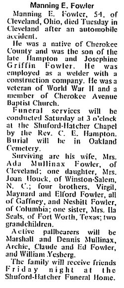
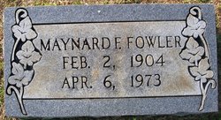
Manning E “El” Fowler
| Birth | : | 2 Oct 1915 Cherokee County, South Carolina, USA |
| Death | : | 17 Feb 1970 Cleveland, Cuyahoga County, Ohio, USA |
| Burial | : | New Hope Cemetery, Peace Valley, Howell County, USA |
| Coordinate | : | 36.8303337, -91.7540359 |
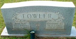
| Description | : | Husband of Ada Mae Mullinax Fowler. |
frequently asked questions (FAQ):
-
Where is Manning E “El” Fowler's memorial?
Manning E “El” Fowler's memorial is located at: New Hope Cemetery, Peace Valley, Howell County, USA.
-
When did Manning E “El” Fowler death?
Manning E “El” Fowler death on 17 Feb 1970 in Cleveland, Cuyahoga County, Ohio, USA
-
Where are the coordinates of the Manning E “El” Fowler's memorial?
Latitude: 36.8303337
Longitude: -91.7540359
Family Members:
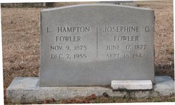
Parent

Spouse
Siblings

Flowers:


Nearby Cemetories:
1. Bennett Chapel Cemetery
Fanchon, Howell County, USA
Coordinate: 36.8025589, -91.7312546
2. Saint Joseph Cemetery
White Church, Howell County, USA
Coordinate: 36.8517100, -91.7876100
3. Barnett Cemetery
Peace Valley, Howell County, USA
Coordinate: 36.7874500, -91.7595020
4. Barnett Cemetery
West Plains, Howell County, USA
Coordinate: 36.7871476, -91.7582962
5. Pleasant View Cemetery
West Plains, Howell County, USA
Coordinate: 36.7900009, -91.8257980
6. Antioch Cemetery
Pomona, Howell County, USA
Coordinate: 36.8725200, -91.8307400
7. Dripping Springs Cemetery
West Plains, Howell County, USA
Coordinate: 36.8175583, -91.8487625
8. Mackey Cemetery
Pomona, Howell County, USA
Coordinate: 36.8659554, -91.8659134
9. Elk Creek Cemetery
Cull, Howell County, USA
Coordinate: 36.7450600, -91.6929245
10. Forest Dell Ebenezer Cemetery
Mountain View, Howell County, USA
Coordinate: 36.9328003, -91.7403030
11. Cantrell Cemetery
Hutton Valley, Howell County, USA
Coordinate: 36.9270300, -91.8112900
12. Center Hill Cemetery
Chapel, Howell County, USA
Coordinate: 36.9415016, -91.7610016
13. Lost Camp Cemetery
Pomona, Howell County, USA
Coordinate: 36.9105988, -91.8566971
14. Francis Cemetery
Cull, Howell County, USA
Coordinate: 36.7299995, -91.6789017
15. Sadie Brown Cemetery
West Plains, Howell County, USA
Coordinate: 36.7967186, -91.8965530
16. Galloway Cemetery
West Plains, Howell County, USA
Coordinate: 36.7529106, -91.8682175
17. Chapel Hill Cemetery
Chapel, Howell County, USA
Coordinate: 36.9358290, -91.6826140
18. Campbell Cemetery
West Plains, Howell County, USA
Coordinate: 36.7563600, -91.8721200
19. Howell Valley Cemetery
West Plains, Howell County, USA
Coordinate: 36.7144012, -91.7953033
20. Oak Lawn Cemetery
West Plains, Howell County, USA
Coordinate: 36.7235985, -91.8419037
21. Jim Willard Farm
Rover, Oregon County, USA
Coordinate: 36.7311100, -91.6496200
22. Lone Pine Cemetery
West Plains, Howell County, USA
Coordinate: 36.7813988, -91.9057999
23. Howell Memorial Park Cemetery
Pomona, Howell County, USA
Coordinate: 36.8460007, -91.9181976
24. Aikens Family Cemetery
Rover, Oregon County, USA
Coordinate: 36.7437200, -91.6285500