
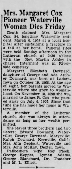
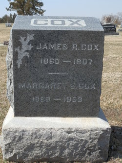
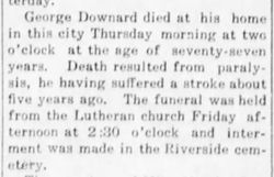
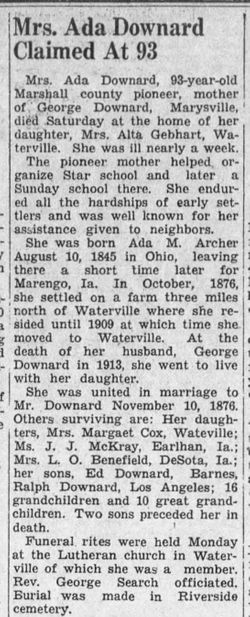
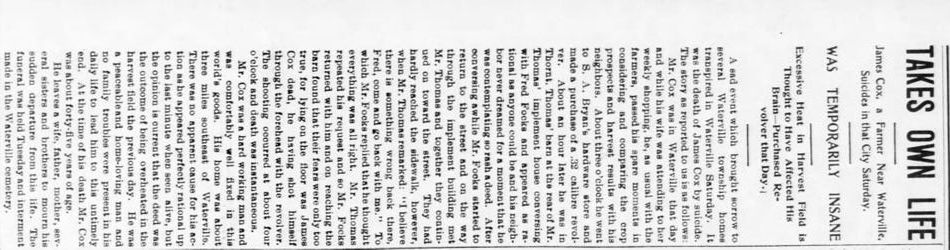
Margaret Elizabeth Downard Cox
| Birth | : | 19 Oct 1868 Ladora, Iowa County, Iowa, USA |
| Death | : | 6 Mar 1953 Marysville, Marshall County, Kansas, USA |
| Burial | : | Ruddick Cemetery, Garfield, Benton County, USA |
| Coordinate | : | 36.4295000, -93.9512400 |
frequently asked questions (FAQ):
-
Where is Margaret Elizabeth Downard Cox's memorial?
Margaret Elizabeth Downard Cox's memorial is located at: Ruddick Cemetery, Garfield, Benton County, USA.
-
When did Margaret Elizabeth Downard Cox death?
Margaret Elizabeth Downard Cox death on 6 Mar 1953 in Marysville, Marshall County, Kansas, USA
-
Where are the coordinates of the Margaret Elizabeth Downard Cox's memorial?
Latitude: 36.4295000
Longitude: -93.9512400
Family Members:
Parent
Spouse
Siblings

Flowers:


Nearby Cemetories:
1. Ruddick Cemetery
Garfield, Benton County, USA
Coordinate: 36.4295000, -93.9512400
2. Union Chapel Cemetery
Garfield, Benton County, USA
Coordinate: 36.4304180, -93.9525340
3. Walnut Hill Cemetery
Brightwater, Benton County, USA
Coordinate: 36.4082985, -93.9907990
4. Williams Cemetery
Benton County, USA
Coordinate: 36.4164009, -94.0002975
5. Snoderly Cemetery
Brightwater, Benton County, USA
Coordinate: 36.4171982, -94.0010986
6. Blaylock Cemetery
Avoca, Benton County, USA
Coordinate: 36.3938700, -93.9799100
7. Liberty Cemetery
Garfield, Benton County, USA
Coordinate: 36.4389000, -94.0105972
8. Bayless Cemetery
Gateway, Benton County, USA
Coordinate: 36.4831009, -93.9539032
9. Dean Cemetery
Benton County, USA
Coordinate: 36.4188995, -94.0211029
10. Reed-Trent Cemetery
Gateway, Benton County, USA
Coordinate: 36.4882800, -93.9574800
11. Clantonville Cemetery
Benton County, USA
Coordinate: 36.4813995, -93.9057999
12. Ford Cemetery
Benton County, USA
Coordinate: 36.4557991, -94.0261002
13. Roller Ridge Cemetery
Gateway, Benton County, USA
Coordinate: 36.4932700, -93.9267500
14. Pratt Cemetery
Garfield, Benton County, USA
Coordinate: 36.4375000, -94.0335999
15. Henson Jennings Cemetery
Garfield, Benton County, USA
Coordinate: 36.4373300, -94.0347000
16. Paces Chapel Cemetery
Benton County, USA
Coordinate: 36.4372940, -94.0350770
17. Webb Cemetery (Defunct)
Benton County, USA
Coordinate: 36.3544006, -93.9356003
18. Alpine Cemetery (Defunct)
Benton County, USA
Coordinate: 36.3558006, -93.9944000
19. Potts Cemetery
Garfield, Benton County, USA
Coordinate: 36.4873620, -94.0228990
20. Martin Cemetery
Larue, Benton County, USA
Coordinate: 36.3465500, -93.9484700
21. Scott Cemetery
Garfield, Benton County, USA
Coordinate: 36.4822006, -94.0314026
22. Beaver Cemetery
Seligman, Barry County, USA
Coordinate: 36.5078011, -93.9143982
23. Seligman Cemetery
Seligman, Barry County, USA
Coordinate: 36.5261002, -93.9336014
24. Twelve Corners Cemetery
Pea Ridge, Benton County, USA
Coordinate: 36.4700012, -94.0622025