
| Birth | : | 23 Oct 1879 Missouri Valley, Harrison County, Iowa, USA |
| Death | : | 23 Jan 1934 Council Bluffs, Pottawattamie County, Iowa, USA |
| Burial | : | Walnut Hill Cemetery, Council Bluffs, Pottawattamie County, USA |
| Coordinate | : | 41.2719002, -95.8255997 |
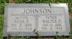
| Description | : | First marriage to Alfred Williams - daughter Elma or Alma Second marriage 25 May 1904 Harrison county, Iowa to Louis Walter Deakins - daughter Iva, sons Earl and Emil Mrs. Marie Deakins, 53, Carson, died at a local hospital of pneumonia Tuesday after a brief illness. She is survived by two daughters, Mrs. Iva Ford of Omaha and Mrs. Elma Achenbaugh of Carson and one son, Earl Deakins of Carson. Funeral services will be held Thursday at 2:30 p.m. at Jackson’s mortuary. Burial will be in Walnut Hill cemetery. Council Bluffs Nonpareil: Wed., 24 Jan 1934 |
frequently asked questions (FAQ):
-
Where is Marie A “Mattie” Mandelko Deakins's memorial?
Marie A “Mattie” Mandelko Deakins's memorial is located at: Walnut Hill Cemetery, Council Bluffs, Pottawattamie County, USA.
-
When did Marie A “Mattie” Mandelko Deakins death?
Marie A “Mattie” Mandelko Deakins death on 23 Jan 1934 in Council Bluffs, Pottawattamie County, Iowa, USA
-
Where are the coordinates of the Marie A “Mattie” Mandelko Deakins's memorial?
Latitude: 41.2719002
Longitude: -95.8255997
Family Members:
Parent

Spouse
Siblings
Children
Flowers:


Nearby Cemetories:
1. Walnut Hill Cemetery
Council Bluffs, Pottawattamie County, USA
Coordinate: 41.2719002, -95.8255997
2. Bikhor Cholim Cemetery
Council Bluffs, Pottawattamie County, USA
Coordinate: 41.2703670, -95.8229350
3. Ridgewood Cemetery
Council Bluffs, Pottawattamie County, USA
Coordinate: 41.2694016, -95.8272018
4. Oak Hill Cemetery
Council Bluffs, Pottawattamie County, USA
Coordinate: 41.2700900, -95.8226400
5. Green Valley Cemetery
Council Bluffs, Pottawattamie County, USA
Coordinate: 41.2743988, -95.8225021
6. Saint Joseph Cemetery
Council Bluffs, Pottawattamie County, USA
Coordinate: 41.2722015, -95.8208008
7. Cedar Lawn Cemetery
Council Bluffs, Pottawattamie County, USA
Coordinate: 41.2694016, -95.8182983
8. Memorial Park Cemetery
Council Bluffs, Pottawattamie County, USA
Coordinate: 41.2644005, -95.8261032
9. Clark Cemetery
Pottawattamie County, USA
Coordinate: 41.2551610, -95.8223390
10. Fairview Cemetery
Council Bluffs, Pottawattamie County, USA
Coordinate: 41.2703018, -95.8480988
11. Garner Cemetery
Council Bluffs, Pottawattamie County, USA
Coordinate: 41.2956161, -95.8001709
12. Stoker-Graybill Cemetery
Council Bluffs, Pottawattamie County, USA
Coordinate: 41.2532620, -95.7751770
13. Maple Grove Cemetery
Council Bluffs, Pottawattamie County, USA
Coordinate: 41.2265560, -95.8187100
14. Evans Cemetery
Crescent, Pottawattamie County, USA
Coordinate: 41.3255997, -95.8368988
15. Lewis Township Cemetery
Council Bluffs, Pottawattamie County, USA
Coordinate: 41.2117004, -95.7938995
16. Gregg Cemetery
Weston, Pottawattamie County, USA
Coordinate: 41.3330000, -95.7931000
17. Council Point Cemetery
Council Bluffs, Pottawattamie County, USA
Coordinate: 41.2110830, -95.8788610
18. Hazel Dell Cemetery
Council Bluffs, Pottawattamie County, USA
Coordinate: 41.3489723, -95.7939911
19. Trinity Cathedral Columbarium
Omaha, Douglas County, USA
Coordinate: 41.2603900, -95.9393660
20. Saint Columbanus Cemetery
Weston, Pottawattamie County, USA
Coordinate: 41.3429440, -95.7435260
21. Crescent Cemetery
Crescent, Pottawattamie County, USA
Coordinate: 41.3664894, -95.8566208
22. Prospect Hill Cemetery
Omaha, Douglas County, USA
Coordinate: 41.2780991, -95.9593964
23. First Central Congregational Columbarium
Omaha, Douglas County, USA
Coordinate: 41.2563456, -95.9658365
24. Nash Chapel Crypt
Omaha, Douglas County, USA
Coordinate: 41.2665090, -95.9721790