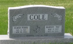
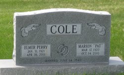
Marion “Pat” Gratz Cole
| Birth | : | 17 Mar 1920 Saint Louis, St. Louis County, Missouri, USA |
| Death | : | 14 Oct 2010 Ogallala, Keith County, Nebraska, USA |
| Burial | : | Saint Luke Evangelical Lutheran Church Cemetery, Knowles, Dodge County, USA |
| Coordinate | : | 43.5718720, -88.5016540 |
| Description | : | Dau.of Archibald C. Gratz and Elizabeth Calais Gratz Wife of Elmer Perry Cole Marion " Pat" Cole, longtime Brule resident, passed away Thursday, October 14, 2010 in the Ogallala Community Hospital after a long life and influence to many friends and family. She was born March 17, 1920 at St. Louis, MO., the daughter of Archibald C. and Elizabeth Calais Gratz. She received her early education at Great Neck, NY. After high school graduation she graduated from Pomona College in Claremont, CA. On June 14, 1942 Pat was united in marriage to Elmer Perry Cole at Claremont. The couple resided in Keith... Read More |
frequently asked questions (FAQ):
-
Where is Marion “Pat” Gratz Cole's memorial?
Marion “Pat” Gratz Cole's memorial is located at: Saint Luke Evangelical Lutheran Church Cemetery, Knowles, Dodge County, USA.
-
When did Marion “Pat” Gratz Cole death?
Marion “Pat” Gratz Cole death on 14 Oct 2010 in Ogallala, Keith County, Nebraska, USA
-
Where are the coordinates of the Marion “Pat” Gratz Cole's memorial?
Latitude: 43.5718720
Longitude: -88.5016540
Family Members:
Spouse
Flowers:
Nearby Cemetories:
1. Saint Luke Evangelical Lutheran Church Cemetery
Knowles, Dodge County, USA
Coordinate: 43.5718720, -88.5016540
2. Emanuel Cemetery
Knowles, Dodge County, USA
Coordinate: 43.5877991, -88.4997025
3. Brownsville Community Cemetery
Brownsville, Dodge County, USA
Coordinate: 43.5995380, -88.5053440
4. Saint Andrews Church Cemetery
LeRoy, Dodge County, USA
Coordinate: 43.5732994, -88.5500336
5. Saint Peters Cemetery
Theresa, Dodge County, USA
Coordinate: 43.5367012, -88.4794006
6. Saint Marys Cemetery
Lomira, Dodge County, USA
Coordinate: 43.5903015, -88.4518967
7. Saint Johns Lutheran Cemetery
Lomira, Dodge County, USA
Coordinate: 43.5877266, -88.4469833
8. Salem Cemetery
Lomira, Dodge County, USA
Coordinate: 43.5872530, -88.4463790
9. Saint Pauls Evangelical Lutheran Cemetery
Brownsville, Dodge County, USA
Coordinate: 43.6167200, -88.4889100
10. Saint Pauls Evangelical Lutheran Cemetery
Lomira, Dodge County, USA
Coordinate: 43.5510050, -88.4430740
11. Mount Pleasant Cemetery
LeRoy, Dodge County, USA
Coordinate: 43.6167800, -88.5263000
12. Old Community Cemetery
Lomira, Dodge County, USA
Coordinate: 43.6086590, -88.4499060
13. Union Cemetery
Theresa, Dodge County, USA
Coordinate: 43.5261002, -88.4514008
14. Saint Gobki Cemetery
Theresa, Dodge County, USA
Coordinate: 43.5144005, -88.4803009
15. Tidyman Cemetery
LeRoy, Dodge County, USA
Coordinate: 43.5482370, -88.5810470
16. Kekoskee Cemetery
Kekoskee, Dodge County, USA
Coordinate: 43.5263390, -88.5612850
17. Saint Paul Cemetery
Kekoskee, Dodge County, USA
Coordinate: 43.5455310, -88.5809180
18. Saint Theresa Memorial Gardens Cemetery
Theresa, Dodge County, USA
Coordinate: 43.5182800, -88.4468500
19. Ebenezer Cemetery
Lomira, Dodge County, USA
Coordinate: 43.6156006, -88.4210968
20. Mount Pleasant Cemetery
Oakfield, Fond du Lac County, USA
Coordinate: 43.6391983, -88.5460968
21. Saint Pauls Cemetery
Theresa, Dodge County, USA
Coordinate: 43.4935989, -88.5141983
22. Old Saint Marys Catholic Cemetery
Mayville, Dodge County, USA
Coordinate: 43.4935200, -88.5394100
23. Miles Farm Cemetery
LeRoy, Dodge County, USA
Coordinate: 43.6251880, -88.5917650
24. Immanuel Evangelical Lutheran Cemetery
Theresa, Dodge County, USA
Coordinate: 43.4860260, -88.4956780


