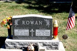
| Birth | : | 16 Nov 1930 |
| Death | : | 22 Mar 2007 Bellevue, Jackson County, Iowa, USA |
| Burial | : | St. Peter & St. Paul's Churchyard, North Curry, Taunton Deane Borough, England |
| Coordinate | : | 51.0258710, -2.9716440 |
| Description | : | OBITUARY COURTESY OF HACHMAN FUNERAL HOME: Marjorie C. Daugherty, 76, of Bellevue, passed away Thursday, March 22nd, 2007 at Mill Valley Care Center in Bellevue. Marjorie was born November 16th, 1930 in Dubuque, daughter of the late Edward and Myrtle (Grant) Rowan Sr. She married James J. Daugherty February 16th, 1949 in Bellevue. He preceded her in death in 1990. ... Read More |
frequently asked questions (FAQ):
-
Where is Marjorie C. Rowan Daugherty's memorial?
Marjorie C. Rowan Daugherty's memorial is located at: St. Peter & St. Paul's Churchyard, North Curry, Taunton Deane Borough, England.
-
When did Marjorie C. Rowan Daugherty death?
Marjorie C. Rowan Daugherty death on 22 Mar 2007 in Bellevue, Jackson County, Iowa, USA
-
Where are the coordinates of the Marjorie C. Rowan Daugherty's memorial?
Latitude: 51.0258710
Longitude: -2.9716440
Family Members:
Parent
Spouse
Siblings
Flowers:
Nearby Cemetories:
1. St. Peter & St. Paul's Churchyard
North Curry, Taunton Deane Borough, England
Coordinate: 51.0258710, -2.9716440
2. Methodist Churchyard
North Curry, Taunton Deane Borough, England
Coordinate: 51.0213358, -2.9731175
3. Independent Baptist Churchyard
North Curry, Taunton Deane Borough, England
Coordinate: 51.0189703, -2.9779346
4. The Baptist Chapel
Stoke St Gregory, Taunton Deane Borough, England
Coordinate: 51.0430441, -2.9375476
5. Buckland Priory
Durston, Taunton Deane Borough, England
Coordinate: 51.0476530, -2.9988180
6. Stoke St Gregory
Stoke St Gregory, Taunton Deane Borough, England
Coordinate: 51.0398130, -2.9310570
7. East Lyng St Bartholomew
Lyng, Sedgemoor District, England
Coordinate: 51.0553000, -2.9534000
8. St John the Baptist Churchyard
Durston, Taunton Deane Borough, England
Coordinate: 51.0478800, -3.0128490
9. Holy Cross at Thornfalcon
Taunton, Taunton Deane Borough, England
Coordinate: 51.0100970, -3.0229420
10. St. Martin's Churchyard
Fivehead, South Somerset District, England
Coordinate: 51.0017010, -2.9239810
11. St. Michael's Churchyard
Creech St Michael, Taunton Deane Borough, England
Coordinate: 51.0223660, -3.0355780
12. Athelney Abbey (Defunct)
Athelney, Sedgemoor District, England
Coordinate: 51.0593000, -2.9345800
13. Fivehead Cemetery
Fivehead, South Somerset District, England
Coordinate: 50.9969923, -2.9231360
14. St. John the Baptist Churchyard
Hatch Beauchamp, Taunton Deane Borough, England
Coordinate: 50.9852830, -2.9900880
15. St. Michael's Churchyard
North Newton, Sedgemoor District, England
Coordinate: 51.0650279, -2.9974435
16. All Saints Churchyard
Curry Mallet, South Somerset District, England
Coordinate: 50.9836110, -2.9497220
17. St. James' Churchyard
Beercrocombe, South Somerset District, England
Coordinate: 50.9791730, -2.9619190
18. St. Catherine's Churchyard
Fivehead, South Somerset District, England
Coordinate: 51.0083009, -2.9000973
19. St. George Churchyard
Ruishton, Taunton Deane Borough, England
Coordinate: 51.0206300, -3.0511400
20. Ruishton Church Cemetery
Ruishton, Taunton Deane Borough, England
Coordinate: 51.0204630, -3.0520420
21. St Mary the Virgin Churchyard
Isle Abbotts, South Somerset District, England
Coordinate: 50.9842010, -2.9240160
22. Saint Andrew's Churchyard
West Hatch, Taunton Deane Borough, England
Coordinate: 50.9840980, -3.0195000
23. Baptist Chapel
Isle Abbotts, South Somerset District, England
Coordinate: 50.9820340, -2.9282940
24. Hatch Beauchamp Baptist Churchyard
Hatch Beauchamp, Taunton Deane Borough, England
Coordinate: 50.9765290, -2.9975820


