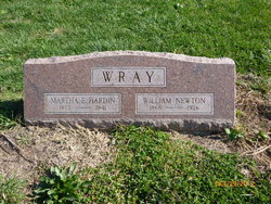
Martha Ellen Hardin Wray
| Birth | : | 31 Aug 1873 Buchanan County, Missouri, USA |
| Death | : | 16 Nov 1941 Guilford, Nodaway County, Missouri, USA |
| Burial | : | St. Thomas' Churchyard, Craven Arms, Shropshire Unitary Authority, England |
| Coordinate | : | 52.4450630, -2.8306870 |
| Description | : | DC 38971 Husband: William Wray Father: David Hardin, b: Missouri Mother: Sally Hall, b: Missouri MRS. ELLEN WRAY DIES AT HOME IN GUILFORD Funeral services will be held at 1:30 o'clock tomorrow afternoon at the Methodist church in Guilford for Mrs. Ellen Wray, 68 years of age, who died at 6:30 o'clock last night at her home in Guilford. She had been in failing health for several years. Burial will be in the Myrtle Tree cemetery, 6 miles northeast of Maryville. She was born August 31, 1873, in Buchanan county and was a daughter of the late Mr. and Mrs.... Read More |
frequently asked questions (FAQ):
-
Where is Martha Ellen Hardin Wray's memorial?
Martha Ellen Hardin Wray's memorial is located at: St. Thomas' Churchyard, Craven Arms, Shropshire Unitary Authority, England.
-
When did Martha Ellen Hardin Wray death?
Martha Ellen Hardin Wray death on 16 Nov 1941 in Guilford, Nodaway County, Missouri, USA
-
Where are the coordinates of the Martha Ellen Hardin Wray's memorial?
Latitude: 52.4450630
Longitude: -2.8306870
Family Members:
Spouse
Children
Flowers:
Nearby Cemetories:
1. Westhope Chapel Burial Ground
Diddlebury, Shropshire Unitary Authority, England
Coordinate: 52.4714690, -2.7818850
2. St Marys Churchyard
Hopesay, Shropshire Unitary Authority, England
Coordinate: 52.4440470, -2.8999020
3. St Michael Churchyard
Edgton, Shropshire Unitary Authority, England
Coordinate: 52.4660500, -2.9044570
4. All Saints Churchyard
Culmington, Shropshire Unitary Authority, England
Coordinate: 52.4334800, -2.7463500
5. St Cuthbert Churchyard
Clungunford, Shropshire Unitary Authority, England
Coordinate: 52.4032350, -2.8909360
6. St Margaret's Churchyard
Acton Scott, Shropshire Unitary Authority, England
Coordinate: 52.5001670, -2.8060920
7. St. Swithin Churchyard
Clunbury, Shropshire Unitary Authority, England
Coordinate: 52.4201670, -2.9261080
8. St. Peter's Churchyard
Diddlebury, Shropshire Unitary Authority, England
Coordinate: 52.4640570, -2.7249740
9. St. Mary the Virgin Churchyard
Bromfield, Shropshire Unitary Authority, England
Coordinate: 52.3873900, -2.7636700
10. St. Edward Churchyard
Hopton Castle, Shropshire Unitary Authority, England
Coordinate: 52.3985700, -2.9369700
11. St Mary's Churchyard
Hopton Castle, Shropshire Unitary Authority, England
Coordinate: 52.3985640, -2.9369870
12. Eaton- under- Heywood St Edith
Eaton-under-Heywood, Shropshire Unitary Authority, England
Coordinate: 52.5056520, -2.7382880
13. Greenhills Cemetery
Church Stretton, Shropshire Unitary Authority, England
Coordinate: 52.5310170, -2.8142480
14. St. Andrew's Churchyard
Hope Bowdler, Shropshire Unitary Authority, England
Coordinate: 52.5271160, -2.7739830
15. St Mary Churchyard
Bedstone, Shropshire Unitary Authority, England
Coordinate: 52.3759660, -2.9284570
16. Church Stretton Cemetery
Church Stretton, Shropshire Unitary Authority, England
Coordinate: 52.5365590, -2.8097950
17. St Laurence Churchyard
Church Stretton, Shropshire Unitary Authority, England
Coordinate: 52.5381750, -2.8087400
18. St. George's Churchyard
Burrington, Herefordshire Unitary Authority, England
Coordinate: 52.3440700, -2.8200100
19. St. John the Baptist Churchyard
Bishop's Castle, Shropshire Unitary Authority, England
Coordinate: 52.4898300, -2.9984000
20. St Mary Churchyard
Bucknell, Shropshire Unitary Authority, England
Coordinate: 52.3592220, -2.9490030
21. St. Mary the Virgin Churchyard
Elton, Shropshire Unitary Authority, England
Coordinate: 52.3345972, -2.7969324
22. St. Barnabas Churchyard
Brampton Bryan, Herefordshire Unitary Authority, England
Coordinate: 52.3470760, -2.9255360
23. Clee St. Margaret Churchyard
Clee St Margaret, Shropshire Unitary Authority, England
Coordinate: 52.4554270, -2.6423086
24. Clun Cemetery
Clun, Shropshire Unitary Authority, England
Coordinate: 52.4215490, -3.0224990


