Martha Ellen Reed Weeks
| Birth | : | 9 Oct 1874 Floyd County, Virginia, USA |
| Death | : | 15 Feb 1945 Christiansburg, Montgomery County, Virginia, USA |
| Burial | : | St. John the Baptist Churchyard, Hellidon, Daventry District, England |
| Coordinate | : | 52.2195780, -1.2464920 |
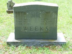
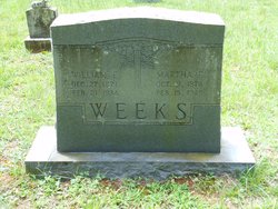
| Inscription | : | William E. / Dec. 27, 1871 / Feb. 21, 1934 // Martha E. / Oct. 9, 1874 / Feb. 15, 1945 // WEEKS |
| Description | : | Daughter of Aaron & Letitia Reed |
frequently asked questions (FAQ):
-
Where is Martha Ellen Reed Weeks's memorial?
Martha Ellen Reed Weeks's memorial is located at: St. John the Baptist Churchyard, Hellidon, Daventry District, England.
-
When did Martha Ellen Reed Weeks death?
Martha Ellen Reed Weeks death on 15 Feb 1945 in Christiansburg, Montgomery County, Virginia, USA
-
Where are the coordinates of the Martha Ellen Reed Weeks's memorial?
Latitude: 52.2195780
Longitude: -1.2464920
Family Members:
Spouse
Children
Flowers:
Nearby Cemetories:
1. St. John the Baptist Churchyard
Hellidon, Daventry District, England
Coordinate: 52.2195780, -1.2464920
2. St. Leonard's Churchyard
Priors Marston, Stratford-on-Avon District, England
Coordinate: 52.2144950, -1.2852860
3. St. Mary the Virgin Churchyard
Staverton, Daventry District, England
Coordinate: 52.2457070, -1.2090230
4. Holy Trinity Churchyard
Charwelton, Daventry District, England
Coordinate: 52.1952913, -1.2044410
5. St John the Baptist Church
Upper Shuckburgh, Stratford-on-Avon District, England
Coordinate: 52.2517680, -1.2732630
6. St. Mary the Virgin
Badby, Daventry District, England
Coordinate: 52.2240200, -1.1820100
7. St Mary's Churchyard
Priors Hardwick, Stratford-on-Avon District, England
Coordinate: 52.2019860, -1.3110330
8. Saint John the Baptist Churchyard
Lower Shuckburgh, Stratford-on-Avon District, England
Coordinate: 52.2598580, -1.2845210
9. St Lawrence Churchyard
Napton-on-the-Hill, Stratford-on-Avon District, England
Coordinate: 52.2477560, -1.3230470
10. St. Peter and St. Paul Churchyard
Preston Capes, Daventry District, England
Coordinate: 52.1893410, -1.1614570
11. Welton Road Daventry
Daventry, Daventry District, England
Coordinate: 52.2643510, -1.1590460
12. Everdon Parish CHurchyard
Everdon, Daventry District, England
Coordinate: 52.2123168, -1.1310740
13. St. Peter's Churchyard
Wormleighton, Stratford-on-Avon District, England
Coordinate: 52.1816070, -1.3469510
14. All Saints Churchyard
Braunston, Daventry District, England
Coordinate: 52.2908200, -1.2140100
15. St Peter's Churchyard
Grandborough, Rugby Borough, England
Coordinate: 52.2988800, -1.2791400
16. St. Nicholas Parish Churchyard
Willoughby, Rugby Borough, England
Coordinate: 52.3027580, -1.2446380
17. St Michael's Church
Stockton, Stratford-on-Avon District, England
Coordinate: 52.2688770, -1.3600030
18. Eydon Burial Ground
Eydon, South Northamptonshire Borough, England
Coordinate: 52.1347200, -1.2724300
19. Canons Ashby
Daventry District, England
Coordinate: 52.1504600, -1.1566400
20. St. Mary’s Churchyard
Canons Ashby, Daventry District, England
Coordinate: 52.1502747, -1.1568058
21. St Mary the Virgin Churchyard
Dodford, Daventry District, England
Coordinate: 52.2396800, -1.1044500
22. St. James Churchyard
Claydon, Cherwell District, England
Coordinate: 52.1467460, -1.3334590
23. St. Martin's Churchyard
Welton, Daventry District, England
Coordinate: 52.2893100, -1.1494100
24. Welton Cemetery
Welton, Daventry District, England
Coordinate: 52.2932126, -1.1567336


