
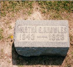
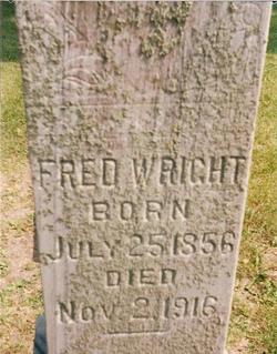
Martha Ellen Wright Knowles
| Birth | : | 22 May 1843 Ohio, USA |
| Death | : | 29 Nov 1923 Liberty Township, Marshall County, Iowa, USA |
| Burial | : | Oak Grove United Methodist Church, Randolph County, USA |
| Coordinate | : | 35.5850000, -79.9944830 |
frequently asked questions (FAQ):
-
Where is Martha Ellen Wright Knowles's memorial?
Martha Ellen Wright Knowles's memorial is located at: Oak Grove United Methodist Church, Randolph County, USA.
-
When did Martha Ellen Wright Knowles death?
Martha Ellen Wright Knowles death on 29 Nov 1923 in Liberty Township, Marshall County, Iowa, USA
-
Where are the coordinates of the Martha Ellen Wright Knowles's memorial?
Latitude: 35.5850000
Longitude: -79.9944830
Family Members:
Parent
Spouse
Siblings

Children
Flowers:


Nearby Cemetories:
1. Calvary Gospel Church Cemetery
Denton, Davidson County, USA
Coordinate: 35.5666000, -80.0096000
2. Calvary Gospel Church Cemetery
Randolph County, USA
Coordinate: 35.5661590, -80.0100350
3. Old Union Cemetery
New Hope, Randolph County, USA
Coordinate: 35.5826800, -79.9581700
4. Salem United Church of Christ Cemetery
Randolph County, USA
Coordinate: 35.6130480, -80.0161770
5. New Hope United Methodist Church Cemetery
Randolph County, USA
Coordinate: 35.5554830, -80.0143500
6. Gravel Hill Baptist Church Cemetery
Denton, Davidson County, USA
Coordinate: 35.5819270, -80.0376700
7. Uwharrie Friends Burial Ground
Asheboro, Randolph County, USA
Coordinate: 35.6024450, -79.9557920
8. Cooper Mountain Cemetery
Randolph County, USA
Coordinate: 35.5790298, -79.9351180
9. Salem United Methodist Church Cemetery
Martha, Randolph County, USA
Coordinate: 35.6255170, -80.0315170
10. Salem Fellowship Church Cemetery
Denton, Davidson County, USA
Coordinate: 35.6268190, -80.0306790
11. Liberty Fellowship Church
Denton, Davidson County, USA
Coordinate: 35.5337785, -80.0094312
12. Bingham Graveyard
Randolph County, USA
Coordinate: 35.5814261, -79.9267622
13. Strieby Congregational United Church of Christ Cem
Asheboro, Randolph County, USA
Coordinate: 35.5598130, -79.9326330
14. Griffon Family Cemetery
New Hope, Randolph County, USA
Coordinate: 35.5285100, -79.9969500
15. Old Fashion Baptist Church Cemetery
Randolph County, USA
Coordinate: 35.6408790, -80.0238300
16. Mathew Skeen Cemetery
Handy, Davidson County, USA
Coordinate: 35.5900200, -80.0694800
17. Siloam United Methodist Church Cemetery
Denton, Davidson County, USA
Coordinate: 35.6105830, -80.0636830
18. Farmer United Methodist Church Cemetery
Farmer, Randolph County, USA
Coordinate: 35.6500330, -79.9767170
19. Old Hillsborough Methodist Church Cemetery
New Hope, Randolph County, USA
Coordinate: 35.5251420, -80.0378970
20. Farmer Baptist Church Cemetery
Farmer, Randolph County, USA
Coordinate: 35.6527300, -79.9716300
21. Eleazer United Methodist Church Cemetery
Eleazer, Randolph County, USA
Coordinate: 35.5179930, -79.9658560
22. Saint Mark's United Methodist Church
Cedar Grove, Randolph County, USA
Coordinate: 35.6454300, -79.9484300
23. Callicutt Memorial Church Cemetery
Asheboro, Randolph County, USA
Coordinate: 35.5607390, -79.9118070
24. Mount Ebal United Methodist Church Cemetery
Denton, Davidson County, USA
Coordinate: 35.6261120, -80.0673550