
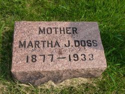

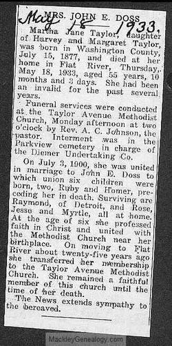
Martha Jane Taylor Doss
| Birth | : | 15 Jul 1877 Washington County, Missouri, USA |
| Death | : | 18 May 1933 Flat River, St. Francois County, Missouri, USA |
| Burial | : | Mountain View Baptist Church Cemetery, Lowgap, Surry County, USA |
| Coordinate | : | 36.5197420, -80.8645570 |
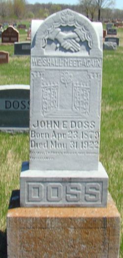
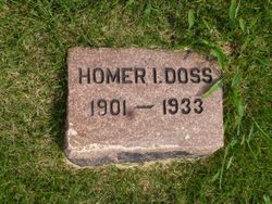
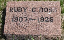
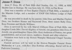
| Description | : | Martha was presided in death by her husband John E. Doss, and her daughter Rubie Cleon Doss. Serviving are her sons Homer I., Raymond L., and Jesse F. Doss and her daughter Rosia (Mrs. Sam Freeman)and Myrtle (Mrs Fred Williams). Martha was buried at Parkview Cemetery, in Farmington Mo. |
frequently asked questions (FAQ):
-
Where is Martha Jane Taylor Doss's memorial?
Martha Jane Taylor Doss's memorial is located at: Mountain View Baptist Church Cemetery, Lowgap, Surry County, USA.
-
When did Martha Jane Taylor Doss death?
Martha Jane Taylor Doss death on 18 May 1933 in Flat River, St. Francois County, Missouri, USA
-
Where are the coordinates of the Martha Jane Taylor Doss's memorial?
Latitude: 36.5197420
Longitude: -80.8645570
Family Members:
Parent
Spouse
Siblings
Children


Nearby Cemetories:
1. Mountain View Baptist Church Cemetery
Lowgap, Surry County, USA
Coordinate: 36.5197420, -80.8645570
2. Liberty Union Baptist Cemetery
Lowgap, Surry County, USA
Coordinate: 36.5273056, -80.8688583
3. Fishers Gap Church Cemetery
Lowgap, Surry County, USA
Coordinate: 36.5231400, -80.8833923
4. Galyean Family Cemetery
Lowgap, Surry County, USA
Coordinate: 36.5346140, -80.8703660
5. Shinault Family Cemetery
Lowgap, Surry County, USA
Coordinate: 36.5333640, -80.8758540
6. Cockerham Family Cemetery
Lowgap, Surry County, USA
Coordinate: 36.5284720, -80.8465830
7. Roaring Gap Baptist Church Cemetery
Lowgap, Surry County, USA
Coordinate: 36.5101929, -80.8920288
8. Barker Graveyard
Lowgap, Surry County, USA
Coordinate: 36.5295540, -80.8340600
9. Mount Vernon Baptist Church Cemetery
Beulah, Surry County, USA
Coordinate: 36.5003624, -80.8213882
10. Montgomery Cemetery
Surry County, USA
Coordinate: 36.5439722, -80.8204722
11. Ladonia Baptist Church Cemetery
Ladonia, Surry County, USA
Coordinate: 36.4780280, -80.8386670
12. Cumberland Knob Cemetery
Surry County, USA
Coordinate: 36.5535100, -80.9073400
13. Goodson Cemetery
Grayson County, USA
Coordinate: 36.5688900, -80.8611200
14. Jarrell Family Cemetery
Lowgap, Surry County, USA
Coordinate: 36.5427860, -80.8103660
15. Smith Family Cemetery
Grayson County, USA
Coordinate: 36.5701930, -80.8726180
16. Low Family Cemetery
Lowgap, Surry County, USA
Coordinate: 36.5461430, -80.7985910
17. Dillard Family Cemetery
Lowgap, Surry County, USA
Coordinate: 36.5500298, -80.8002243
18. Saddle Mountain Baptist Church Cemetery
Ennice, Alleghany County, USA
Coordinate: 36.5082300, -80.9386300
19. Payne Cemetery
Lowgap, Surry County, USA
Coordinate: 36.4947220, -80.7928060
20. Round Peak Primitive Baptist Church Cemetery
Round Peak, Surry County, USA
Coordinate: 36.5145264, -80.7861633
21. Holder Cemetery
Lowgap, Surry County, USA
Coordinate: 36.5364670, -80.7875720
22. Isaacks Family Cemetery
Mount Airy, Surry County, USA
Coordinate: 36.4621670, -80.8236670
23. Sarah Isaacs Cemetery
Franklin, Surry County, USA
Coordinate: 36.4636110, -80.8205830
24. Fairview Memorial Gardens
Low Gap, Grayson County, USA
Coordinate: 36.5784080, -80.9056970