
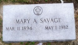
Mary Anna Kaipust Savage
| Birth | : | 11 Mar 1894 Platte Center, Platte County, Nebraska, USA |
| Death | : | 1 May 1982 Columbus, Platte County, Nebraska, USA |
| Burial | : | St Mary's Churchyard, Yate, South Gloucestershire Unitary Authority, England |
| Coordinate | : | 51.5431600, -2.4139020 |
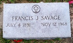
| Description | : | Daughter of John & Agatha (Kiolbasa) Kaipust. Married to Francis J. Savage on 5-19-1915. From the web site: http://www.rootsweb.com/~neplatte/vitals/vitals1915.html The Columbus Journal, May 20, 1915 MARRIED SAVAGE-KIAPAST--A beautiful marriage ceremony celebrated with all its religious solemnity and religious dignity was that which united Mr. Frank Savage of Tarnov and Miss Mary Kiapast of this place on Wednesday morning, May 18th. The marriage rite was performed and the Nuptial High Mass celebrated by the pastor, Rev. Father Laborius. The attendants were the Misses Julia Kiapast and Katie Savage, Messrs. Joe Kiapast and Joe Savage. After the ceremony the happy couple proceeded to the home of the bride... Read More |
frequently asked questions (FAQ):
-
Where is Mary Anna Kaipust Savage's memorial?
Mary Anna Kaipust Savage's memorial is located at: St Mary's Churchyard, Yate, South Gloucestershire Unitary Authority, England.
-
When did Mary Anna Kaipust Savage death?
Mary Anna Kaipust Savage death on 1 May 1982 in Columbus, Platte County, Nebraska, USA
-
Where are the coordinates of the Mary Anna Kaipust Savage's memorial?
Latitude: 51.5431600
Longitude: -2.4139020
Family Members:
Parent
Spouse
Siblings

Children
Flowers:


Nearby Cemetories:
1. St Mary's Churchyard
Yate, South Gloucestershire Unitary Authority, England
Coordinate: 51.5431600, -2.4139020
2. St. John the Baptist Churchyard
Chipping Sodbury, South Gloucestershire Unitary Authority, England
Coordinate: 51.5389590, -2.3944150
3. St Peter's Churchyard & Wapley Burial Ground
Dodington, South Gloucestershire Unitary Authority, England
Coordinate: 51.5157603, -2.4138814
4. St Peter's Churchyard
Wapley, South Gloucestershire Unitary Authority, England
Coordinate: 51.5157000, -2.4137400
5. St James the Less Churchyard
Iron Acton, South Gloucestershire Unitary Authority, England
Coordinate: 51.5490390, -2.4619310
6. Mayshill Cemetery
South Gloucestershire Unitary Authority, England
Coordinate: 51.5562160, -2.4691663
7. Saint John the Baptist Churchyard
Old Sodbury, South Gloucestershire Unitary Authority, England
Coordinate: 51.5336010, -2.3561470
8. Church of the Holy Trinity
Rangeworthy, South Gloucestershire Unitary Authority, England
Coordinate: 51.5742000, -2.4536000
9. Westerleigh Crematorium
Westerleigh, South Gloucestershire Unitary Authority, England
Coordinate: 51.5044380, -2.4291520
10. St Peter's Churchyard
Frampton Cotterell, South Gloucestershire Unitary Authority, England
Coordinate: 51.5359115, -2.4801320
11. St Mary's Churchyard ( Private )
Dodington, South Gloucestershire Unitary Authority, England
Coordinate: 51.5172820, -2.3588590
12. St James the Elder Churchyard
Horton, South Gloucestershire Unitary Authority, England
Coordinate: 51.5637860, -2.3390110
13. Horton Church Cemetery
Horton, South Gloucestershire Unitary Authority, England
Coordinate: 51.5647100, -2.3388100
14. Holy Trinity Churchyard
Wickwar, South Gloucestershire Unitary Authority, England
Coordinate: 51.5985120, -2.4006930
15. Bristol Memorial Woodlands
Alveston, South Gloucestershire Unitary Authority, England
Coordinate: 51.5725340, -2.4983540
16. St Mary Magdelene Churchyard
Tormarton, South Gloucestershire Unitary Authority, England
Coordinate: 51.5082250, -2.3334930
17. St Mary Churchyard
Hawkesbury, South Gloucestershire Unitary Authority, England
Coordinate: 51.5807290, -2.3359910
18. Memorial Woodland Cemetery
Bristol Unitary Authority, England
Coordinate: 51.5754490, -2.5013060
19. St James Parish Churchyard
Tytherington, South Gloucestershire Unitary Authority, England
Coordinate: 51.5932110, -2.4799250
20. St. Michael the Archangel Churchyard
Winterbourne, South Gloucestershire Unitary Authority, England
Coordinate: 51.5269000, -2.5183600
21. St Peter's Churchyard
Dyrham, South Gloucestershire Unitary Authority, England
Coordinate: 51.4804500, -2.3735900
22. St Anne's Churchyard
Siston, South Gloucestershire Unitary Authority, England
Coordinate: 51.4752200, -2.4499900
23. St Andrew Churchyard
Cromhall, South Gloucestershire Unitary Authority, England
Coordinate: 51.6121930, -2.4456930
24. St James The Great Churchyard Cemetery
Abson, South Gloucestershire Unitary Authority, England
Coordinate: 51.4716858, -2.4257848