
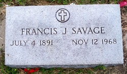
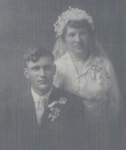
Francis Joseph “Frank” Savage
| Birth | : | 7 Jul 1891 Tarnov, Platte County, Nebraska, USA |
| Death | : | 12 Nov 1968 Columbus, Platte County, Nebraska, USA |
| Burial | : | St Mary's Churchyard, Yate, South Gloucestershire Unitary Authority, England |
| Coordinate | : | 51.5431600, -2.4139020 |
| Plot | : | Section 2, Row 2 |
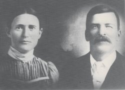
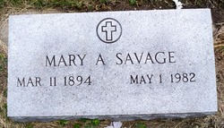
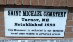
| Description | : | Listed in the records of St. Michael's church at Tarnov, Nebraska as: Franciscum Szawica, born July 7, 1891 and baptized July 19, 1891. Godparents were John Jaworski and Marianna Szawica. Note: Family says they celebrated his birthday on July 4th not July 7th which was his actual birth day. Married to Mary A. Kaipust on 5-19-1915 at St. Joseph's Catholic Church located at Platte Center, NE. ----------------------------------- From the web site: http://www.usgennet.org/usa/ne/county/platte/vitals/vitals1915.html The Columbus Journal, May 20, 1915 SAVAGE-KIAPAST--A beautiful marriage ceremony celebrated with all its religious solemnity and religious dignity was that which united Mr. Frank Savage of Tarnov and Miss Mary Kiapast of this place... Read More |
frequently asked questions (FAQ):
-
Where is Francis Joseph “Frank” Savage's memorial?
Francis Joseph “Frank” Savage's memorial is located at: St Mary's Churchyard, Yate, South Gloucestershire Unitary Authority, England.
-
When did Francis Joseph “Frank” Savage death?
Francis Joseph “Frank” Savage death on 12 Nov 1968 in Columbus, Platte County, Nebraska, USA
-
Where are the coordinates of the Francis Joseph “Frank” Savage's memorial?
Latitude: 51.5431600
Longitude: -2.4139020
Family Members:
Parent

Spouse
Siblings

Children
Flowers:


Nearby Cemetories:
1. St Mary's Churchyard
Yate, South Gloucestershire Unitary Authority, England
Coordinate: 51.5431600, -2.4139020
2. St. John the Baptist Churchyard
Chipping Sodbury, South Gloucestershire Unitary Authority, England
Coordinate: 51.5389590, -2.3944150
3. St Peter's Churchyard & Wapley Burial Ground
Dodington, South Gloucestershire Unitary Authority, England
Coordinate: 51.5157603, -2.4138814
4. St Peter's Churchyard
Wapley, South Gloucestershire Unitary Authority, England
Coordinate: 51.5157000, -2.4137400
5. St James the Less Churchyard
Iron Acton, South Gloucestershire Unitary Authority, England
Coordinate: 51.5490390, -2.4619310
6. Mayshill Cemetery
South Gloucestershire Unitary Authority, England
Coordinate: 51.5562160, -2.4691663
7. Saint John the Baptist Churchyard
Old Sodbury, South Gloucestershire Unitary Authority, England
Coordinate: 51.5336010, -2.3561470
8. Church of the Holy Trinity
Rangeworthy, South Gloucestershire Unitary Authority, England
Coordinate: 51.5742000, -2.4536000
9. Westerleigh Crematorium
Westerleigh, South Gloucestershire Unitary Authority, England
Coordinate: 51.5044380, -2.4291520
10. St Peter's Churchyard
Frampton Cotterell, South Gloucestershire Unitary Authority, England
Coordinate: 51.5359115, -2.4801320
11. St Mary's Churchyard ( Private )
Dodington, South Gloucestershire Unitary Authority, England
Coordinate: 51.5172820, -2.3588590
12. St James the Elder Churchyard
Horton, South Gloucestershire Unitary Authority, England
Coordinate: 51.5637860, -2.3390110
13. Horton Church Cemetery
Horton, South Gloucestershire Unitary Authority, England
Coordinate: 51.5647100, -2.3388100
14. Holy Trinity Churchyard
Wickwar, South Gloucestershire Unitary Authority, England
Coordinate: 51.5985120, -2.4006930
15. Bristol Memorial Woodlands
Alveston, South Gloucestershire Unitary Authority, England
Coordinate: 51.5725340, -2.4983540
16. St Mary Magdelene Churchyard
Tormarton, South Gloucestershire Unitary Authority, England
Coordinate: 51.5082250, -2.3334930
17. St Mary Churchyard
Hawkesbury, South Gloucestershire Unitary Authority, England
Coordinate: 51.5807290, -2.3359910
18. Memorial Woodland Cemetery
Bristol Unitary Authority, England
Coordinate: 51.5754490, -2.5013060
19. St James Parish Churchyard
Tytherington, South Gloucestershire Unitary Authority, England
Coordinate: 51.5932110, -2.4799250
20. St. Michael the Archangel Churchyard
Winterbourne, South Gloucestershire Unitary Authority, England
Coordinate: 51.5269000, -2.5183600
21. St Peter's Churchyard
Dyrham, South Gloucestershire Unitary Authority, England
Coordinate: 51.4804500, -2.3735900
22. St Anne's Churchyard
Siston, South Gloucestershire Unitary Authority, England
Coordinate: 51.4752200, -2.4499900
23. St Andrew Churchyard
Cromhall, South Gloucestershire Unitary Authority, England
Coordinate: 51.6121930, -2.4456930
24. St James The Great Churchyard Cemetery
Abson, South Gloucestershire Unitary Authority, England
Coordinate: 51.4716858, -2.4257848