
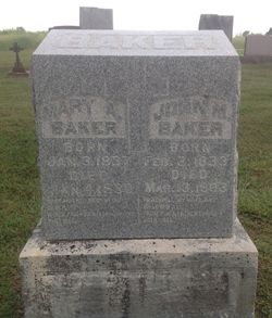

Mary Anna Zey Baker
| Birth | : | 3 Jan 1837 |
| Death | : | 4 Jan 1930 |
| Burial | : | Newton Road Cemetery, Rushden, East Northamptonshire Borough, England |
| Coordinate | : | 52.2882140, -0.5859750 |
frequently asked questions (FAQ):
-
Where is Mary Anna Zey Baker's memorial?
Mary Anna Zey Baker's memorial is located at: Newton Road Cemetery, Rushden, East Northamptonshire Borough, England.
-
When did Mary Anna Zey Baker death?
Mary Anna Zey Baker death on 4 Jan 1930 in
-
Where are the coordinates of the Mary Anna Zey Baker's memorial?
Latitude: 52.2882140
Longitude: -0.5859750
Family Members:
Spouse

Children
Flowers:

Rest in Peace, Mary...(Mary was the daughter of John and Catherine (Weingartner) Zey. Her husband was John Martin Baker.)
Left by Anonymous on 19 May 2012

Left by Anonymous on 23 Apr 2013
Rest in Peace, Mary...(Mary was the daughter of John and Catherine (Weingartner) Zey. Her husband was John Martin Baker.)
Left by Anonymous on 19 May 2012
Left by Anonymous on 23 Apr 2013


Nearby Cemetories:
1. Newton Road Cemetery
Rushden, East Northamptonshire Borough, England
Coordinate: 52.2882140, -0.5859750
2. St Mary Churchyard
Rushden, East Northamptonshire Borough, England
Coordinate: 52.2885570, -0.5973860
3. St. Mary the Virgin Churchyard
Higham Ferrers, East Northamptonshire Borough, England
Coordinate: 52.3065500, -0.5915240
4. Higham Ferrers Cemetery
Higham Ferrers, East Northamptonshire Borough, England
Coordinate: 52.3084850, -0.5945270
5. St Lawrence Churchyard
Wymington, Bedford Borough, England
Coordinate: 52.2694310, -0.6017230
6. St. Peter Churchyard
Newton Bromswold, East Northamptonshire Borough, England
Coordinate: 52.2815200, -0.5376600
7. St. John the Baptist Churchyard
Chelveston, East Northamptonshire Borough, England
Coordinate: 52.3112800, -0.5501200
8. Irchester Saint Katherine Churchyard
Irchester, Wellingborough Borough, England
Coordinate: 52.2843900, -0.6446900
9. Irchester Cemetery
Irchester, Wellingborough Borough, England
Coordinate: 52.2848000, -0.6456000
10. New Irthlingborough Cemetery
Irthlingborough, East Northamptonshire Borough, England
Coordinate: 52.3178531, -0.6294229
11. St Peter's Churchyard
Irthlingborough, East Northamptonshire Borough, England
Coordinate: 52.3251642, -0.6101925
12. St Mary the Virgin Churchyard
Podington, Bedford Borough, England
Coordinate: 52.2539100, -0.6220900
13. St. Mary the Virgin Churchyard
Yelden, Bedford Borough, England
Coordinate: 52.2930600, -0.5182700
14. St. Michael's Church
Farndish, Bedford Borough, England
Coordinate: 52.2638108, -0.6416839
15. St. Margaret of Antioch Churchyard
Knotting, Bedford Borough, England
Coordinate: 52.2599172, -0.5323686
16. Stanwick Cemetery
Stanwick, East Northamptonshire Borough, England
Coordinate: 52.3298800, -0.5531500
17. St. Laurence Churchyard Stanwick
Stanwick, East Northamptonshire Borough, England
Coordinate: 52.3324970, -0.5628585
18. All Saints Churchyard
Souldrop, Bedford Borough, England
Coordinate: 52.2433000, -0.5584000
19. St. Mary Magdalene Churchyard
Melchbourne, Bedford Borough, England
Coordinate: 52.2770600, -0.4935690
20. Wollaston
Wollaston, Wellingborough Borough, England
Coordinate: 52.2581088, -0.6726313
21. London Road Cemetery
Wellingborough, Wellingborough Borough, England
Coordinate: 52.2986000, -0.6878000
22. All Saints Churchyard
Wellingborough, Wellingborough Borough, England
Coordinate: 52.3010890, -0.6879730
23. St Mary the Virgin Churchyard
Shelton, Bedford Borough, England
Coordinate: 52.3076000, -0.4852000
24. Raunds Cemetery
Raunds, East Northamptonshire Borough, England
Coordinate: 52.3494100, -0.5467400