
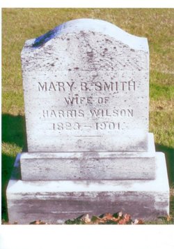
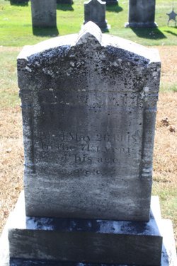
Mary Brown Smith Wilson
| Birth | : | Dec 1823 Glocester, Providence County, Rhode Island, USA |
| Death | : | 5 Apr 1901 Glocester, Providence County, Rhode Island, USA |
| Burial | : | St Bertoline's Churchyard, Barthomley, Cheshire East Unitary Authority, England |
| Coordinate | : | 53.0681360, -2.3483600 |
frequently asked questions (FAQ):
-
Where is Mary Brown Smith Wilson's memorial?
Mary Brown Smith Wilson's memorial is located at: St Bertoline's Churchyard, Barthomley, Cheshire East Unitary Authority, England.
-
When did Mary Brown Smith Wilson death?
Mary Brown Smith Wilson death on 5 Apr 1901 in Glocester, Providence County, Rhode Island, USA
-
Where are the coordinates of the Mary Brown Smith Wilson's memorial?
Latitude: 53.0681360
Longitude: -2.3483600
Family Members:
Parent
Spouse
Siblings
Children
Flowers:


Nearby Cemetories:
1. St Bertoline's Churchyard
Barthomley, Cheshire East Unitary Authority, England
Coordinate: 53.0681360, -2.3483600
2. Audley Cemetery
Audley, Newcastle-Under-Lyme Borough, England
Coordinate: 53.0550140, -2.3103040
3. St James the Great Churchyard
Audley, Newcastle-Under-Lyme Borough, England
Coordinate: 53.0548480, -2.3014800
4. Audley Methodist Church Cemetery
Bignall End, Newcastle-Under-Lyme Borough, England
Coordinate: 53.0574320, -2.2944720
5. Christ Church Churchyard
Alsager, Cheshire East Unitary Authority, England
Coordinate: 53.0977630, -2.3166660
6. Weston Cemetery
Weston, Cheshire East Unitary Authority, England
Coordinate: 53.0680861, -2.4095799
7. St Margaret Churchyard
Betley, Newcastle-Under-Lyme Borough, England
Coordinate: 53.0328100, -2.3658530
8. St Mary Magdalene Churchyard
Alsager, Cheshire East Unitary Authority, England
Coordinate: 53.0960640, -2.3071370
9. St. Matthew's Churchyard
Haslington, Cheshire East Unitary Authority, England
Coordinate: 53.1011010, -2.3933740
10. St Michael's
Haslington, Cheshire East Unitary Authority, England
Coordinate: 53.0946170, -2.4097820
11. St. John Churchyard
Alsagers Bank, Newcastle-Under-Lyme Borough, England
Coordinate: 53.0365350, -2.2939860
12. Wheelock Heath Baptist Chapelyard
Sandbach, Cheshire East Unitary Authority, England
Coordinate: 53.1132940, -2.3730320
13. St Martin Churchyard
Talke, Newcastle-Under-Lyme Borough, England
Coordinate: 53.0755440, -2.2618170
14. All Saints Churchyard
Church Lawton, Cheshire East Unitary Authority, England
Coordinate: 53.0987050, -2.2679300
15. Christ Church Churchyard
Wheelock, Cheshire East Unitary Authority, England
Coordinate: 53.1247500, -2.3768200
16. Holy Trinity Churchyard
Chesterton, Stratford-on-Avon District, England
Coordinate: 53.0418320, -2.2523770
17. St. Chad Churchyard
Wybunbury, Cheshire East Unitary Authority, England
Coordinate: 53.0452760, -2.4488530
18. Crewe Cemetery & Crematorium
Crewe, Cheshire East Unitary Authority, England
Coordinate: 53.1030540, -2.4415159
19. Chesterton Cemetery
Newcastle-under-Lyme, Newcastle-Under-Lyme Borough, England
Coordinate: 53.0352240, -2.2500500
20. St Luke the Evangelist Churchyard
Silverdale, Newcastle-Under-Lyme Borough, England
Coordinate: 53.0170300, -2.2736770
21. All Saints Churchyard
Odd Rode, Cheshire East Unitary Authority, England
Coordinate: 53.1142100, -2.2644690
22. St. Michael Churchyard
Crewe, Cheshire East Unitary Authority, England
Coordinate: 53.1058200, -2.4475200
23. Attwood Cemetery
Kidsgrove, Newcastle-Under-Lyme Borough, England
Coordinate: 53.0889200, -2.2350700
24. Keele Cemetery
Keele, Newcastle-Under-Lyme Borough, England
Coordinate: 53.0087192, -2.2813113