
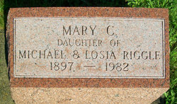
Mary C. Riggle
| Birth | : | 1897 |
| Death | : | 1982 |
| Burial | : | St Peter in the Forest, Allendale, Northumberland Unitary Authority, England |
| Coordinate | : | 54.8313100, -2.2350600 |
frequently asked questions (FAQ):
-
Where is Mary C. Riggle's memorial?
Mary C. Riggle's memorial is located at: St Peter in the Forest, Allendale, Northumberland Unitary Authority, England.
-
When did Mary C. Riggle death?
Mary C. Riggle death on 1982 in
-
Where are the coordinates of the Mary C. Riggle's memorial?
Latitude: 54.8313100
Longitude: -2.2350600
Family Members:
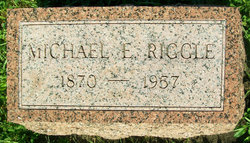
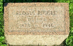
Parent
Siblings
Flowers:


Nearby Cemetories:
1. St Peter in the Forest
Allendale, Northumberland Unitary Authority, England
Coordinate: 54.8313100, -2.2350600
2. Carrshield Anglican Churchyard
Allendale, Northumberland Unitary Authority, England
Coordinate: 54.8229010, -2.3083050
3. Limestone Brae, Wesleyan Methodist Chapel
Allendale, Northumberland Unitary Authority, England
Coordinate: 54.8425890, -2.3207386
4. Limestone Brae Burial Ground
Allendale, Northumberland Unitary Authority, England
Coordinate: 54.8441180, -2.3233520
5. Allendale Woodland Cemetery
Allendale, Northumberland Unitary Authority, England
Coordinate: 54.8932624, -2.2618136
6. Allendale Old Cemetery
Allendale, Northumberland Unitary Authority, England
Coordinate: 54.8941650, -2.2612690
7. Friends Meeting House
Allendale, Northumberland Unitary Authority, England
Coordinate: 54.8957750, -2.2598490
8. St. Cuthbert's Churchyard
Allendale, Northumberland Unitary Authority, England
Coordinate: 54.8978260, -2.2545020
9. Copt Hill Churchyard
Cowshill, Durham Unitary Authority, England
Coordinate: 54.7626700, -2.2320470
10. Saint Thomas Heatherycleugh
Cowshill, Durham Unitary Authority, England
Coordinate: 54.7601700, -2.2264200
11. Burtree Ford Cemetery
Cowshill, Durham Unitary Authority, England
Coordinate: 54.7587910, -2.2286680
12. St John's Churchyard
Nenthead, Eden District, England
Coordinate: 54.7903000, -2.3434180
13. High House Methodist Chapel Graveyard
Allendale, Northumberland Unitary Authority, England
Coordinate: 54.8844090, -2.3285218
14. Nenthead Cemetery
Nenthead, Eden District, England
Coordinate: 54.7947260, -2.3536210
15. Keenley Methodist Chapel Graveyard
Allendale, Northumberland Unitary Authority, England
Coordinate: 54.9053170, -2.3075580
16. St James Churchyard
Hunstanworth, Durham Unitary Authority, England
Coordinate: 54.8358650, -2.0807750
17. Old Churchyard
Eastgate, Durham Unitary Authority, England
Coordinate: 54.7751710, -2.0933400
18. Rookhope Cemetery
Eastgate, Durham Unitary Authority, England
Coordinate: 54.7744000, -2.0916800
19. Church of Saint Mary
Blanchland, Northumberland Unitary Authority, England
Coordinate: 54.8484000, -2.0541000
20. St John the Evangelist Churchyard
Garrigill, Eden District, England
Coordinate: 54.7677610, -2.3977800
21. Redwing Chapel Churchyard
Garrigill, Eden District, England
Coordinate: 54.7702390, -2.4071080
22. St Augustine Churchyard
Alston, Eden District, England
Coordinate: 54.8128980, -2.4397250
23. Alston Cemetery
Alston, Eden District, England
Coordinate: 54.8083540, -2.4416430
24. All Saints Churchyard
Eastgate, Durham Unitary Authority, England
Coordinate: 54.7445590, -2.0745270